You never know what’s lurking in the fine print. Usually that’s taken to be a bad thing, but yesterday I took a look at a map I’ve owned for years and discovered a fine thing in the fine print.
First, the map. It’s laminated, and so in excellent shape. I got it when we went up to northern Wisconsin in 2003. At 16¾ inches x 10⅝ inches, it’s beyond the capacity of my simple scanner, so here’s a large detail from the midsection of the map: instantly recognizable as the ice-water mansion Lake Superior.
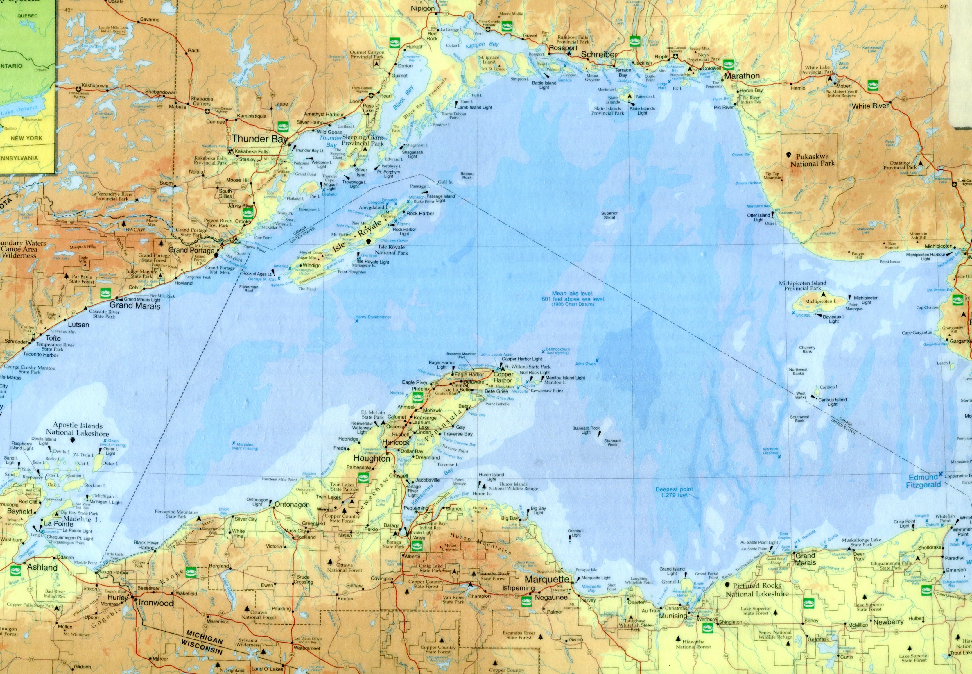 Lake Superior Port Cities Inc., publisher of Lake Superior Magazine, published the map in 2001. It’s a quietly gorgeous map whose shadings not only indicate elevation above and below the surface of the lake, but are pleasing to the eye. Besides towns and roads, it notes all of the various state forests and parks along the shores of Lake Superior, plus the national lakeshores and the single national monument, Grand Portage in Minnesota.
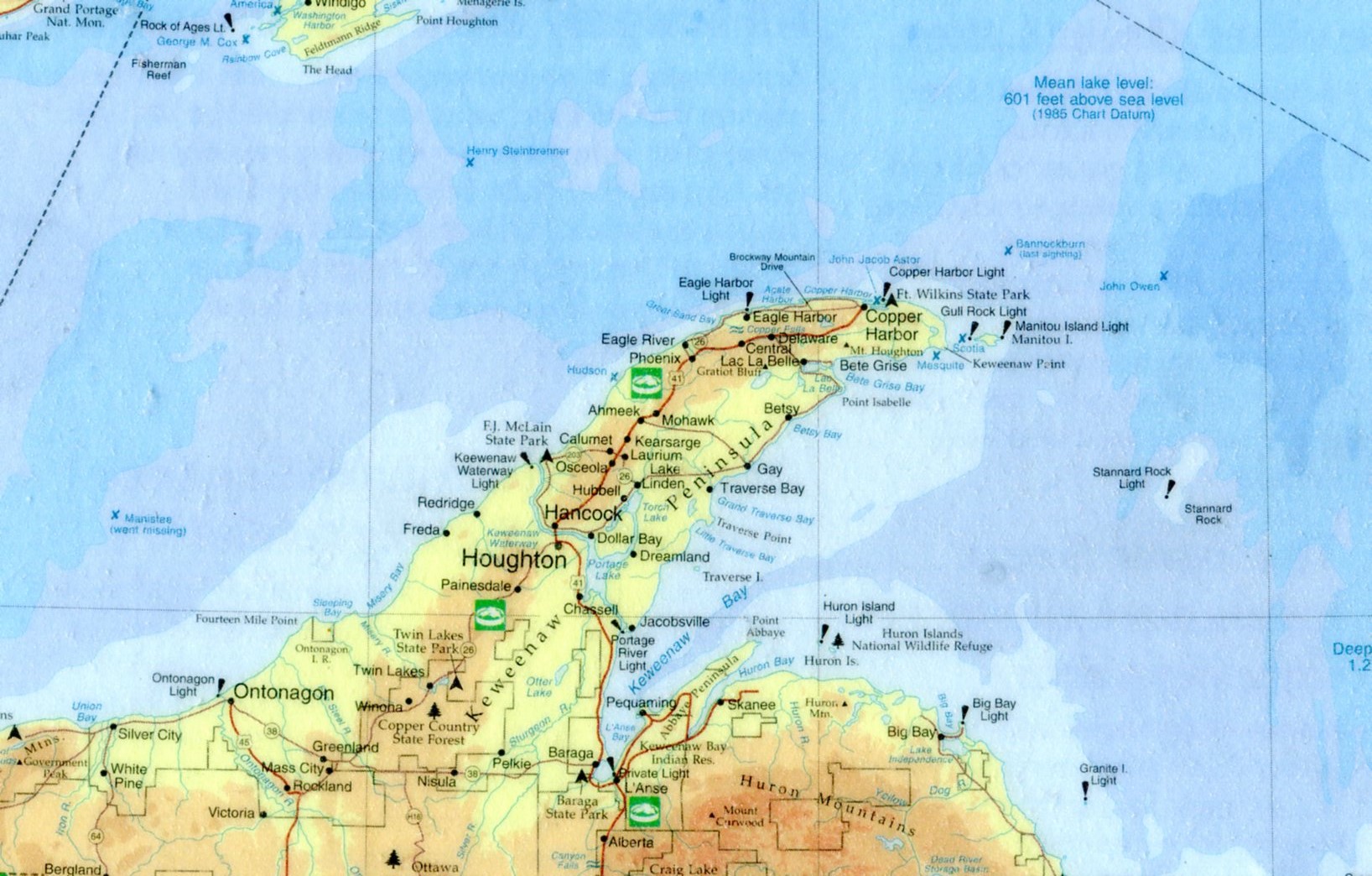
Here’s a closeup of Keweenaw Peninsula, the UP’s UP, and a place I surely must see.
 Very small versions of the Lake Superior Circle Tour sign mark a network of roads that circumscribe the lake. If I had the time, that’s a drive I wouldn’t hesitate to do. I remember the first time I visited Lake Superior — Labor Day weekend 1989 — I was driving between Munising and Marquette and I saw one of the signs. I hadn’t realized there was a Lake Superior version of the drive; the Lake Michigan Circle Tour signs can be seen even in the Chicago area and, in fact, I’ve done my own version of circum-driving that lake twice (once was that ’89 weekend).
Instantly I was taken with the notion of driving around Lake Superior. I was by myself and could have done it. I didn’t have my passport, but you didn’t need a passport to visit Canada in those days. I hadn’t planned to take any time off after Labor Day, but I could have called in sick for a few days, something I very rarely did. But no. I was entirely too responsible.
On the lake itself, the map also features lighthouses and the sites of notable shipwrecks. Some of the lighthouses are probably easy enough to see, but others are impossibly remote, such as the Stannard Rock Light, more than 20 nautical miles southeast of Keweenaw Point, slap in the middle of the lake.
As the for the wrecks, few will ever see them in the chilly Superior waters (average temp, 40 degrees F.). The most famed of them, naturally, is the Edmund Fitzgerald, but it has a lot of company, such as the Onoko, Henry Steinbrenner, John Owen, Western Reserve, Gale Staples, Niagara, Superior City and others.
A handful wrecks are marked but also noted “went missing,” such as the Owen and Manistee. To quote Wiki on that ship: “The Manistee was a packet steamship that went missing on Lake Superior on November 10, 1883. It was presumed to have sunk, with no surviving crew or passengers. The cause remains a mystery, and the wreckage was never discovered.” Sometimes Gitche Gumee just eats ships, it seems.
As for the fine print, way at the bottom right corner of the map, in about 3-point print, it says, “Design/Cartography by Matt Kania.” He’s easy enough to find: Map Hero, maker of custom maps. Looks like he’s done a lot of wonderful maps besides Superior. If I had any talent for it, I’d do the same.