Pea Ridge National Military Park

I’ve been told that I visited Pea Ridge National Military Park when I was small, four or five years old, during my family’s short vacation in the Ozarks in the mid-60s. Went to Branson, Mo., on that trip as well, when it was merely a minor lake resort and not Las Vegas designed by Ned Flanders.

I don’t remember any of that. I have wisps of other memories, which would be my very first travel memories, but I’m not sure how reliable they are. Maybe that was the trip when billboards for a place called Villa Capri Motel gave my brother Jim giggle fits, because he insisted that it was pronounced “Villa Crap-Eye,” or when he was similarly amused by Skelly gas stations, which became “Skeleton” gas stations, but I’m not sure.

I do remember visiting the future Crater of Diamonds State Park in Arkansas, which would have been a private tourist attraction in those days. The allure of diamonds got through even to a small child (good work, De Beers), but of course we didn’t find any, and the only impression I have now is that it was a hot, dusty, boring field.

When we arrived at Pea Ridge on April 7 around lunchtime, I was essentially seeing it with new eyes. So was Yuriko, who’d never heard it. No surprise, since it isn’t one of the more famed Civil War battles. I expect many Americans, maybe most, haven’t heard of it either. Not necessarily a big deal. Go through a list like this and be impressed by just how many battles there were.Pea Ridge National Military Park

A one-way road circles the 4,300 acres of the battlefield, with signs to explain what happened where in March ’62. About 27,000 men on both sides clashed there, including some hundreds of Cherokee and other Indian cavalry fighting for the Confederacy, or rather, against the United States. They were fully acknowledged as part of the fighting force at the small museum at the visitors center, though perhaps not with as much detail as this article.

Unlike other, more famed battlefields – such as Vicksburg – the place isn’t chockablock with memorials or statues or the like. There are some cannons and restored fences, however.Pea Ridge National Military Park Pea Ridge National Military Park

The view from the East Overlook. The battlefield, I’ve read, is one of the better preserved ones, probably because growth has only come recently to this corner of Arkansas.Pea Ridge National Military Park

Elkhorn Tavern, which was once on the Telegraph Road, a thoroughfare name I find particularly evocative.Pea Ridge National Military Park Pea Ridge National Military Park

Much fighting took place nearby, and the building was pressed into service as a field hospital for a time. First it was captured by Union forces, then Confederates on the first day of the battle. Union forces took it back on the decisive second day, as the battle went their way.

“The Federals used the tavern as a military telegraph station until Confederate guerrillas burned it in 1863,” the NPS says. “The present building is a reconstruction.” Including, if you look closely, an animal skull on the roof — an elk, no doubt.

Thorncrown Chapel

My bourgeois householder impulses kicked in today and I mowed the lawn, which, happily, is sporting a nice crop of dandelions. I’m actually fond of dandelions, so I suppose my lawncare impulses aren’t entirely conventional. I gave up raking leaves years ago, too, and don’t regret it. I look at my lawn in the spring and think, where did all those leaves go? To nourish the soil, of course.

On April 7, we left Harrison, Arkansas, where we’d spent the night, and headed for Dallas by not quite the most direct route. Soon we passed through Eureka Springs. We wanted to amble around town a bit, but parking was hard to find and – this rankles on a Sunday – costs money. So on we went, west on U.S. 62. Moments out of town, I spotted the sign for Thorncrown Chapel.

The chapel rises gracefully on its Arkansas hillside, whose trees at that moment were budding, but not obscuring the view. Good timing for a visit.Thorncrown Chapel Thorncrown Chapel

Wood and glass and light and – air. So light you’d think it’s going to float away, despite however many pounds of wood it represents. Thorncrown Chapel

Thorncrown Chapel

“Thorncrown Chapel… is the most celebrated piece of architecture built in Arkansas,” says the Encyclopedia of Arkansas, which is a tall statement. But that opinion seems to have some weight, considering the structure’s honors and spots on architecture lists, besides the acclaim accorded architect E. Fay Jones.

“Eighteen wood columns line each of the long sides,” the article notes. “The columns are connected overhead by a latticelike diagonal web of light wood pieces, creating the building’s most important visual feature. This interior bracing is Jones’s inspired inversion of Gothic architecture’s transfer of the loads of a building to “flying buttresses” that brace the walls from the outside.”

The Mildred B. Cooper Memorial Chapel, also by Jones, has similar charms, but I’d say Thorncrown kicked things up a notch in design.

We happened to be in time for the Sunday nondenominational service, so we sat in for a while. No admission, but we were happy to make a donation.Thorncrown Chapel

Much better images are here. Seems that the muse was with E. Fay Jones when he designed the chapel for a couple who happened to own the land, Jim and Dell Reed, and who had this built instead of a retirement home, tapping Jones, a one-time student of Frank Lloyd Wright, for the job; and ultimately seeing it completed in 1980, after divine intervention was said to be a factor in the financing.

One of the speakers at the service – I can’t call it the sermon or homily, just a chat – who looked my age or a little more, was their son, Doug Reed, I think. Maybe he sees chapel every day, or often enough, but somehow a sense of awe came through as he described how the Thorncrown came to be. That didn’t make an impression on me in the moment, but the more I think about it, the more impressive it is, how familiarity hasn’t effaced awe for him.

Hot Springs NP, 2007

Even though it was a digital camera, and a fairly good one when I acquired it ca. 2001, my Nikon Coolpix 4300 had its limits. Mainly, memory. At least compared to the vast memories of current devices.

So that might account for the fact that I only have one image at Hot Springs National Park in March 2007. Or maybe I wasn’t much in the mood for using a camera there. It’s good to put the camera down for a while sometimes, no matter how photogenic the place you find yourself.

This is it, the Hernando de Soto statue at Fordyce Bathhouse. The image itself is only passable.

The sculpture is in the former men’s bath hall and was a centerpiece of a fountain.

The Fordyce Bathhouse is a building of exceptional beauty in its public spaces and state-of-the-art health and fitness equipment of the roaring ’20s in its bath spaces.

“The Fordyce is now the park’s visitor center, and offers tours of its elaborate facilities – self-guided, but at a good price, free,” I wrote at the time. “The building style, Spanish Renaissance Revival, is supposed to pay tribute to Hernando de Soto, who supposedly came this way. No fancy bath houses were necessary for passing Spaniards, Indians or other early visitors, however, who apparently soaked in pools fed by the springs wherever they found them.”

Fort Smith National Historic Site

As historic sites go, Fort Smith National Historic Site is definitely worth a look, with its main building (former barracks-courthouse-jail), reconstructed gallows, site of a first fort, outline of the second fort’s former walls, parkland and walking paths, and a nice view of the Arkansas River.Fort Smith National Historic Site

But what really caught my attention during my visit on April 17 was painted on one of the sidewalks.Fort Smith National Historic Site Fort Smith National Historic Site

“The line on the sidewalk behind you represents the 1834 boundary between Indian Territory and Arkansas,” the sign nearby simply says. “Indian Territory was defined as the unsettled land west of the Mississippi River not including states or previously organized territories.”

I should note that the line on the sidewalk isn’t the current border between Arkansas and Oklahoma. But it’s pretty close — at that point the line is on the eastern bank of the Arkansas River, at least according to Google Maps (not quite an infallible source).

The pink arrow points to about where the painted line is. As you can see, the modern border zags a bit to the west at that point, so that all of the land of the historic site — and the city of Fort Smith, for that matter — is in Arkansas.

At some point, that line must have been straight and a slice of land east of Arkansas-Poteau confluence was Indian Territory, if the sidewalk line is correct. This Encyclopedia of Arkansas article seems to deal with a border adjustment in the area, in the context of the Choctaw Nation-Arkansas border, which was the subject of decades of dispute.

But the article says the strip was “two miles wide and twelve miles long,” and the Fort Smith slice looks nowhere near that large, so I don’t know how the above border adjustment was made. Some Arkansas or Choctaw historian might, but I’m going to leave it at that.

The fort was originally established in 1817 to patrol the neighboring Indian Territory and named for the otherwise little-remembered Gen. Thomas Smith. The U.S. Army abandoned the first fort in 1824, but by that time a town had grown up near the fort. The Army built a second fort in 1838 that it occupied, except for a short Confederate period, until 1871.

The site of the first fort, entirely forgotten and not re-discovered until 1958.
Fort Smith National Historic Site

During the Army period, the handsome main building of the second fort served as a barracks. Late in the 19th century, it was a federal courthouse and jail. Now it’s a museum. Closed when I visited, unfortunately.

Also handsome: the Historic Commissary Building. It too was closed.Also handsome: the Historic Commissary Building. It too was closed.

Flat stones that mark where the second fort wall used to be. A sign pointed out that most later U.S. Army forts didn’t bother with walls.
Fort Smith National Historic Site

Another prime attraction — maybe the prime attraction — is the rebuilt gallows.
Fort Smith National Historic Site

“With the largest criminal jurisdiction of any federal court at the time, the Western District of Arkansas handled an extraordinary number of murder and rape cases,” a sign in front of the gallows says. “When a jury found defendants guilty in these capital cases, federal law mandated the death penalty. In Fort Smith, that meant an execution by hanging on a ‘crude and unsightly’ gallows.”

A separate sign lists everyone hanged at Fort Smith during the years (1873-96) that federal executions took place on the site, 87 men all together. The famed Judge Isaac C. Parker sentenced 160 people (156 men, four women) to death in that court, 79 of whom were eventually hanged. “George Maledon, known as the Prince of Hangmen, served as executioner at over half of the Fort Smith hangings,” the sign also noted.

Main Street, Van Buren, Arkansas

I spent the night of April 16 in Alma, Arkansas, a part of greater Fort Smith, and the next morning I decided to see Fort Smith National Historic Site, so I headed into town via U.S. 71 Business. My breakfast was in a sack in the seat next to me, so I was also looking for a place to stop and eat. Sometimes small parks are just the place, either to eat in the car away from traffic whizzing by, or to find an outdoor table.

I saw a small sign that said PARK –> , so I turned right off the main road. Soon I found myself at the intersection of 6th and Main Street, main artery of the picturesque Van Buren Historic District. I parked on Main and ate my breakfast, and naturally got out for a walk after that.Van Bureau Main Street

Van Bureau Main Street
Except for Fort Smith itself, Van Buren is the largest place in the Fort Smith MSA, with about 23,600 residents, founded on the Arkansas River well over a century and a half ago. Van Buren, Arkansas

Much more recently, the river got pretty angry.

Though a bit chilly that Saturday, the weather was comfortable enough for a walk on Main Street, mostly sporting buildings of a certain vintage.Van Buren Main Street Van Buren Main Street Van Buren Main Street

Older buildings, but with distinctly contemporary uses, including the likes of Rethreadz Boutique, The Vault 1905 Sports Grill, Sophisticuts, Corner Gifts, The Vault, and Red Hot Realty.Van Buren Main Street Van Buren Main Street Van Buren Main Street

At Main and 4th is the Crawford County Courthouse, dating from 1842 and as such, according to Wiki anyway, the oldest operating courthouse west of the Mississippi.

Crawford County Arkansas Courthouse
It wouldn’t be much of a Southern courthouse without its Confederate memorial, dating from 1899.Crawford County Arkansas Courthouse

A detail from the base. Something you don’t see too often.
Crawford County Arkansas Courthouse

Something you see even less at courthouses, North or South: a Greek goddess, namely Hebe, goddess of youth and youthful joy.Crawford County Arkansas Courthouse Hebe Crawford County Arkansas Courthouse Hebe

The original was a 1908 gold-painted iron statue, according to a sign on site. This 2003 bronze is a replacement for the original, which now resides in the Crawford County Museum.

Off to one side of the courthouse is the Albert Pike Schoolhouse, thought to be one of the oldest extant buildings in Arkansas, built ca. 1820 and later relocated to its current spot.
 Albert Pike Schoolhouse

Another memorial on the grounds. I’d never heard of Cyrus Alder before; now I have.

Cyrus Alder memorial
Finally, I spotted some interesting walls in the vicinity of the courthouse. Such as what looks to be a palimpsest ghost sign wall.
Van Buren ghost wall

In an alley across the street from the courthouse, this. It’s fairly new, as you’d think. Streetview of May 2018 has a blank wall there.Van Buren You Are Here mural Van Buren You Are Here mural

My knee-jerk reaction: izzat so? I never did find the park that I thought might be a good place for breakfast. I did much better, enjoying a bit of serendipity on the road, since I had no inkling of Van Buren, Arkansas before I found myself there.

Southern Loop ’21

Just returned today from a series of long drives totaling 2,610 miles that took me down the length of Illinois and through parts of Missouri, Tennessee, Mississippi, Arkansas, Louisiana and Texas. Dallas was the prime destination, where I visited Jay for the first time in well over a year.

I drove on crowded Interstates, nearly empty Interstates, U.S. highways, state and county roads, and urban streets, and logged a lot of miles on roads through farmland, forests and small towns. I crossed the Mississippi more than once, including on a bridge that felt so narrow that moving the slightest bit out of your lane would crash you into the side of the bridge or oncoming traffic. Rain poured sometimes, drizzle was common and there was plenty of evidence of a wet spring in the ubiquitous puddles and the lush greenery of the South.

On I-20 east of Shreveport, I spotted a small truck carrying mattresses that had stopped on the right shoulder ahead of me. Then I spotted the mattress he’d dropped in the middle of the road, a few seconds ahead of me. The truck was 50 feet or so further than the mattress; he’d probably stopped to pick it up, but fortunately hadn’t got out of his truck yet. To my left another car was just behind me, so I threaded the needle to the right of the mattress and left of the truck, missing both.

I left metro Chicago mid-morning on April 9, making my way to Carbondale in southern Illinois, and took a short afternoon hike to the Pomona Natural Bridge in Shawnee National Forest. Overnight an enormous thunderstorm passed over that part of the state, and intermittent rain continued the next day as I drove through the southernmost tip of Illinois, a slice of Missouri, the length of West Tennessee and into Mississippi, arriving in Clarksdale after dark.

En route I’d stopped for a couple of hours at Fort Pillow State Park and about half that long in downtown Memphis. Dinner that night was Chinese food from a Clarksdale takeout joint called Rice Bowl.

On the morning of April 11, I took a walk in downtown Clarksdale, then drove south — stopping to mail postcards in Alligator, Mississippi — and spent most of the afternoon at Vicksburg National Military Park.
Alligator, Mississippi

As the afternoon grew late, I walked around downtown Vicksburg and one of its historic cemeteries. The next day I headed west across the Mississippi River into Louisiana, where I stopped at Poverty Point World Heritage Site, locale of an ancient Indian settlement much older than Cahokia, or the pyramids outside Mexico City for that matter.

I stayed in Dallas from the evening of April 12 to the morning of the 16th, mostly at Jay’s house, though I did visit my nephew Sam and his family, meeting their delightful two-year-old daughter, my grandniece, for the first time.

On the 16th I drove north from Dallas, spending a little time in Paris, Texas. In Oklahoma I headed on small roads to the Talimena Scenic Drive through Winding Stair Mountain National Recreation Area, where I followed its winding (as the name says), up and down two-lane path through near-mountainous terrain. In a thick fog. That was excitement enough for one day, but that didn’t stop me from visiting Heavener Runestone Park toward the end of the afternoon. I spent the night just outside Fort Smith, Arkansas.

The next morning I headed toward Fort Smith and chanced across the picturesque Main Street of Van Buren, a large suburb of Fort Smith, or maybe its mate in a small twin cities. I also looked around the Crawford County Courthouse before crossing the Arkansas River to Fort Smith proper, spending an hour or so at Fort Smith National Historic Site. From there a long and tiring drive took me to Belleville, Illinois for the last night of the trip, stopping only for gas, food and a quick look at the Mildred B. Cooper Memorial Chapel.

The place I stayed in Belleville last night was an inexpensive motel at the end of the town’s downtown shopping and restaurant street. Up earlier than usual this morning, around 7, I took a walk in area’s handsome, near-empty streets and sidewalks. Before leaving town I stopped at the Cathedral of Saint Peter, and a few miles away, Our Lady of the Snows shrine.

That ought to be enough for any trip, I thought, till I saw that the world’s largest catsup bottle in nearby Collinsville as a point of interest on my paper map (I now use both paper and electronic, which complement each other). So I went to see that. Later heading north on I-55, I thought, that ought to be enough for any trip, till I saw the pink elephant. Pink Elephant

That is, the Pink Elephant Antique Mall northeast of St. Louis, which I’ve driven by many times over the years, but never stopped at. This time I did and it became the cherry on the sundae of the trip.

The Branson Scenic Railway

During my visit to Branson in November 2012, I took an excursion on the Branson Scenic Railway. Nothing like hopping aboard a pleasure train pulled by mid-century locomotives.
Branson Scenic RailwaySpecifically, according to the railroad’s web site, “BSRX 98, Locomotive, 1951 EMD F9PH, rebuilt 1981, has HEP (Formerly B&O, then MARC #83).” I looked up HEP, at least: head-end power. Nice to know that the locomotive has hep.

The web site further explains: “Traveling on a working commercial railroad line, the train’s direction of travel… is determined by the Missouri and Northern Arkansas Railroad just prior to departure. At that time, the train will go either north or south. The northern route goes as far as Galena, Missouri, to the James River Valley; and the southern route extends into Arkansas to the Barren Fork Trestle.”

We went south into Arkansas, which isn’t actually that far from Branson, across water and through hills and woods and tunnels, just as the leaves were turning nicely.Near Branson Mo

Near Branson MoNear Branson MoNear Branson Mo“The construction of the White River Railway in the early 1900s made the area accessible for tourists and is largely responsible for the development of Branson and the Ozarks as a tourism destination… The route crosses the White River in Branson, now Lake Taneycomo, and then runs along side of it after taking a fifty-mile short cut over the Ozark Mountains.

“This was part of the Missouri Pacific Railroad between Kansas City, Missouri, and Little Rock, Arkansas. It became a part of the Union Pacific after the UP bought the MOPAC. The Missouri and Northern Arkansas Railroad now operates the line.

“In 1993, the Branson Scenic Railway was formed, and through a lease arrangement with the MNA, runs excursions through this historic route March through December.”

A train through the Alps it isn’t, but it’s scenic all the same.

Electric Emblem, Grand Commandery of Colorado

Unusually warm and especially windy today. I would have spent more time on the deck, but the wind was distracting. That and dust was blowing in from the baseball field in the park.

I’ve seen people playing baseball there sometimes, even in recent weeks. But no peewee football in the park yet. That’s still going on as far as I know, despite concussion worries, and the occasional brawl among the parents.

I correspond by postcard with a handful of people. Sometimes I get delightful cards. This one from a correspondent in Tennessee is definitely that.

It depicts, according to the back of the card, the Electric Emblem, Grand Commandery  of Colorado (Knights Templar, who are still around). The card has a copyright date of 1913, which as far as I understand puts it in the public domain. Something so delightful should be.

My correspondent tells me the card was once owned by her grandmother in Arkansas, “a prolific card writer,” she says. Makes it even more special to get in the mail. Millennials have no idea what they’re missing by giving up on postcards.

GTT 2016 This & That

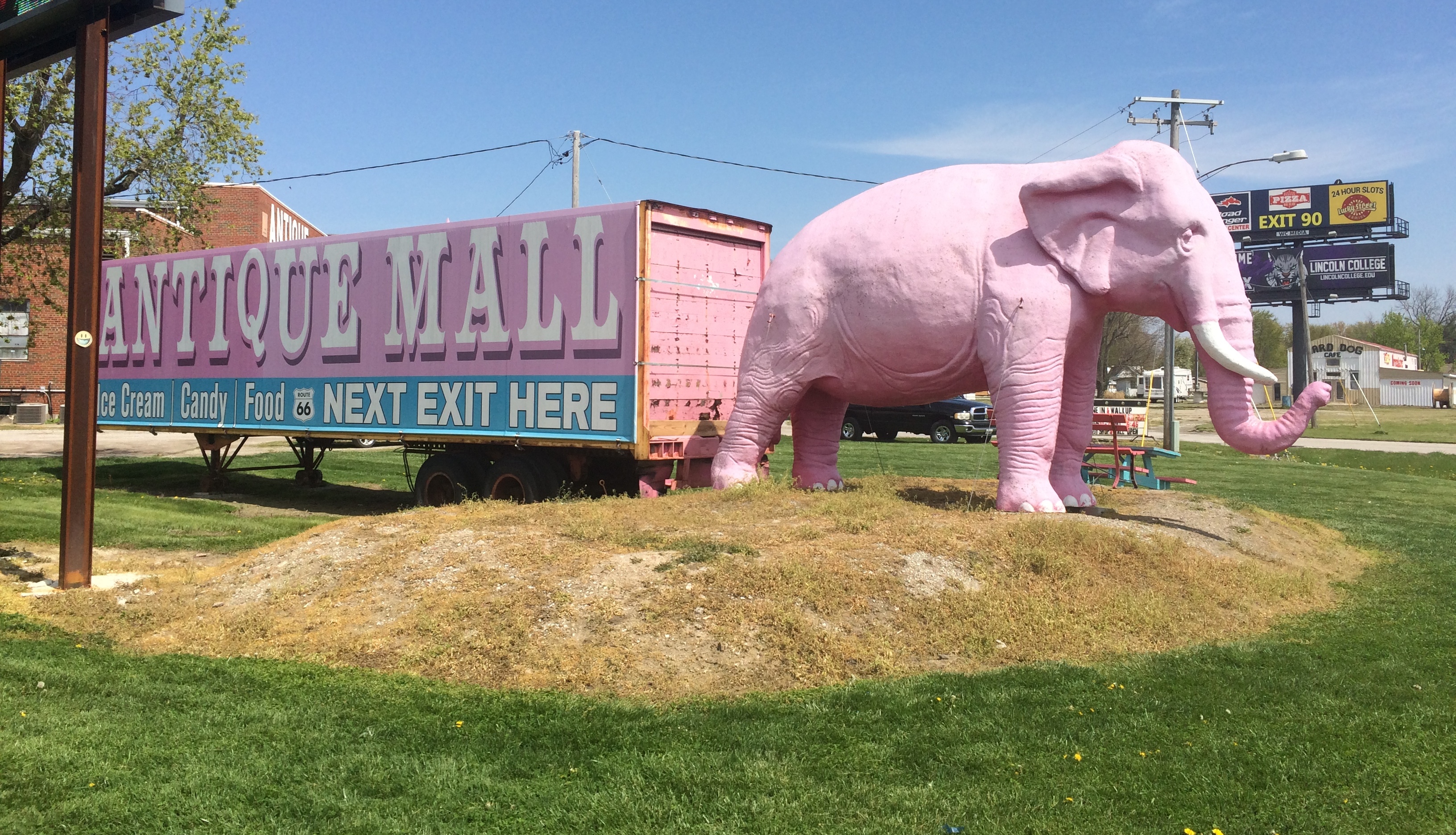
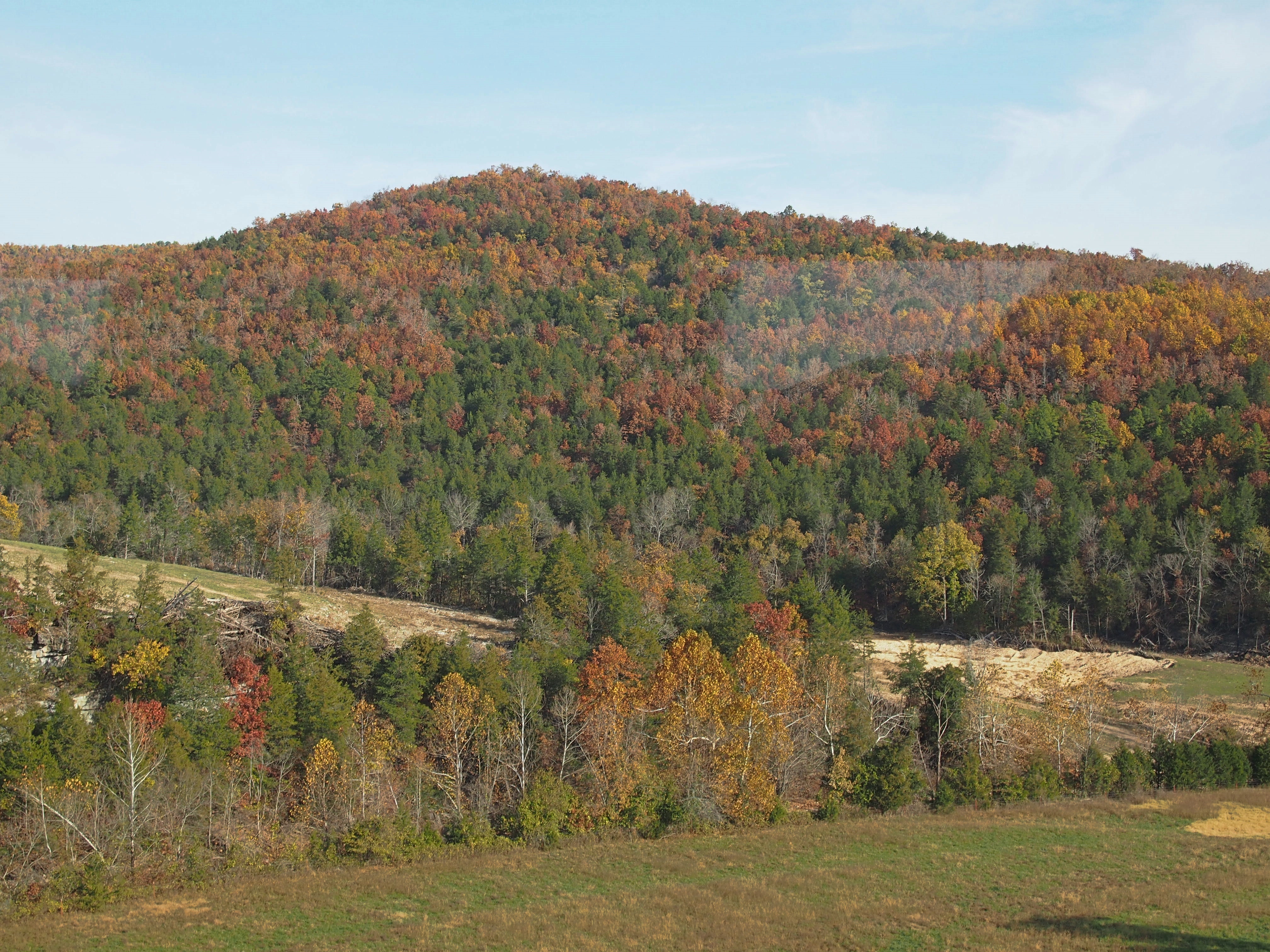
“We’re going to see some bears,” I told a groggy Ann as we drove through Nashville on the Saturday morning we were there.

“I don’t want to go to a zoo.”

“Not those kinds of bears.”

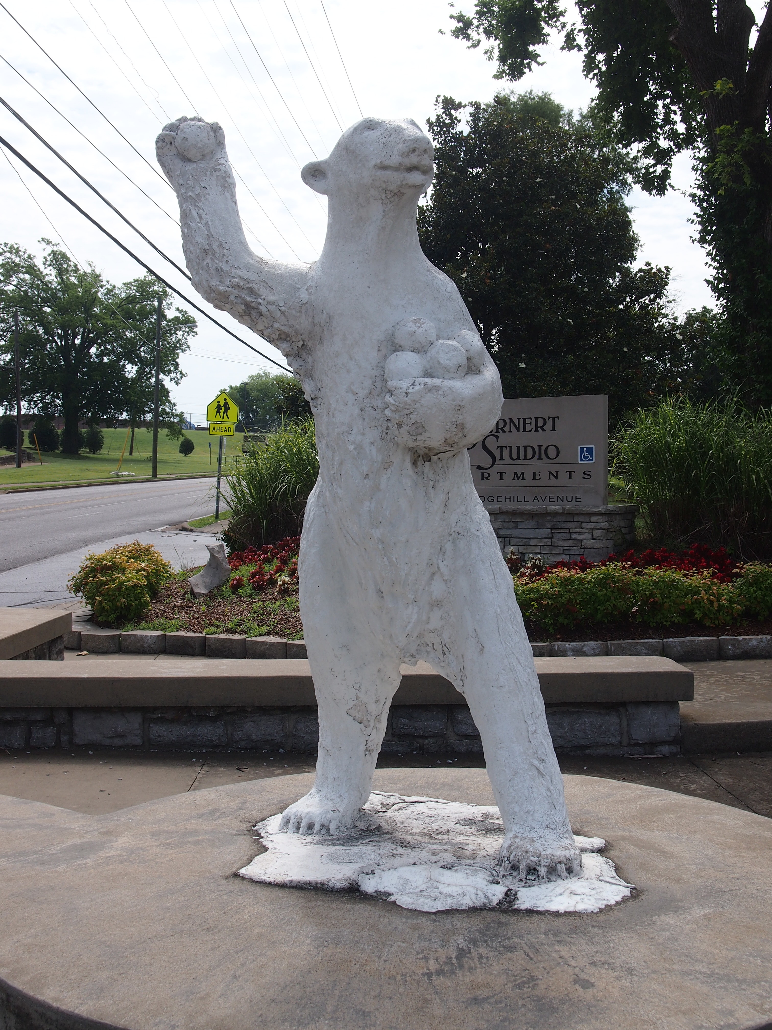
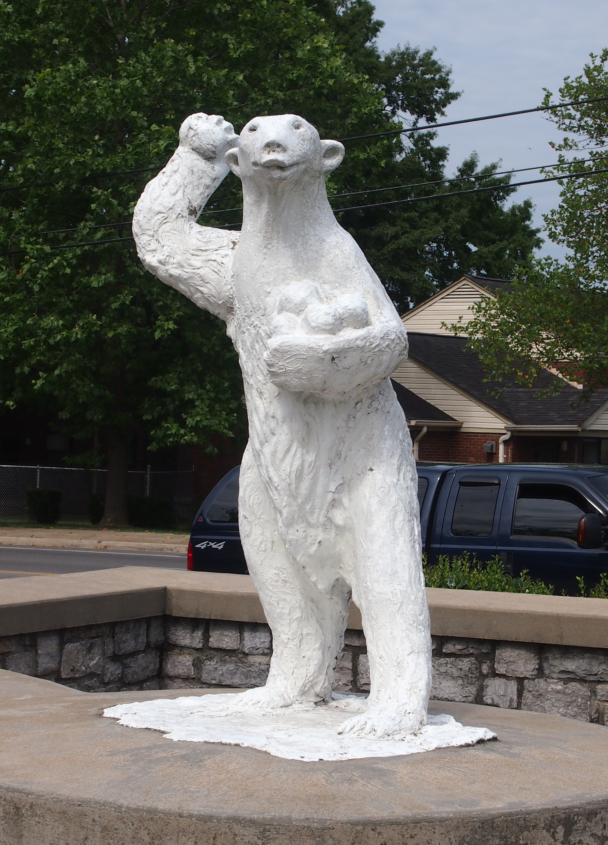
These kinds of bears.
12th and Edgehill bears, Nashville July 2016
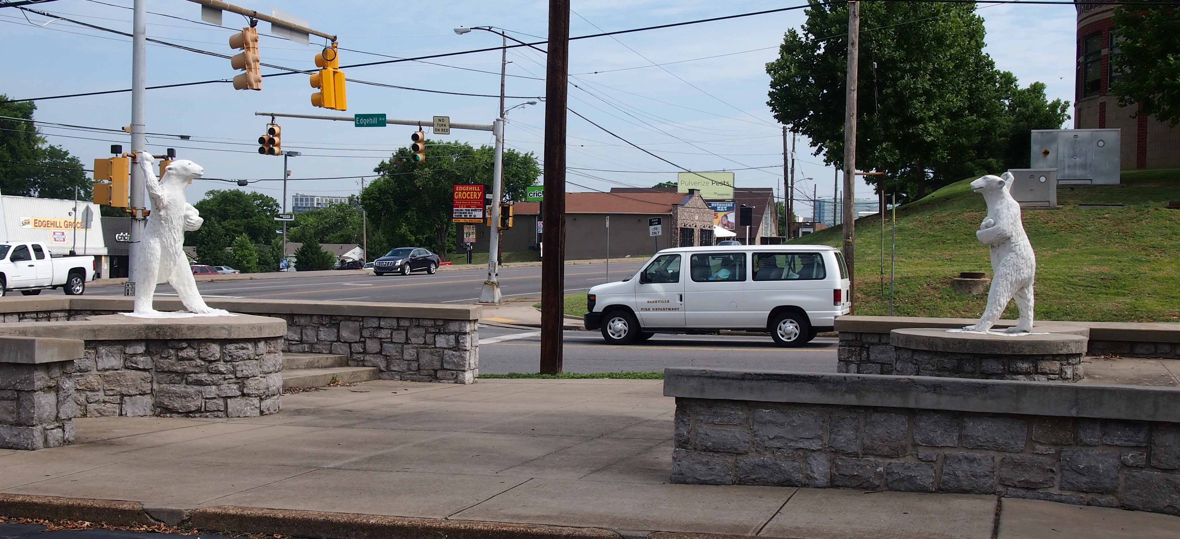
Standing concrete bears, snowballs in hand, ready to toss them. To cut ’n’ paste from the now-defunct Nashville City Paper (March 15, 2004): “The polar bear statues have long been a symbol of the community of Edgehill. They were the creation of the late Gio Vacchino, who owned the Mattei Plaster Relief Ornamental Company around 1930. They were constructed as advertisements for the Polar Bear Frozen Custard shops on Gallatin Road and West End Avenue, which closed after World War II.

“Edgehill resident Zema Hill bought the bears and placed them in the neighborhood in the early 1940s. He placed two in front of a funeral home and two in front of his house where they eventually became a symbol and part of the culture of Edgehill. They stood at 1408 Edgehill Ave. for more than 60 years. The two funeral home bears were sold to a North Nashville resident in 1952.”

12th and Edgehill bears, Nashville July 201612th and Edgehill bears, Nashville July 2016
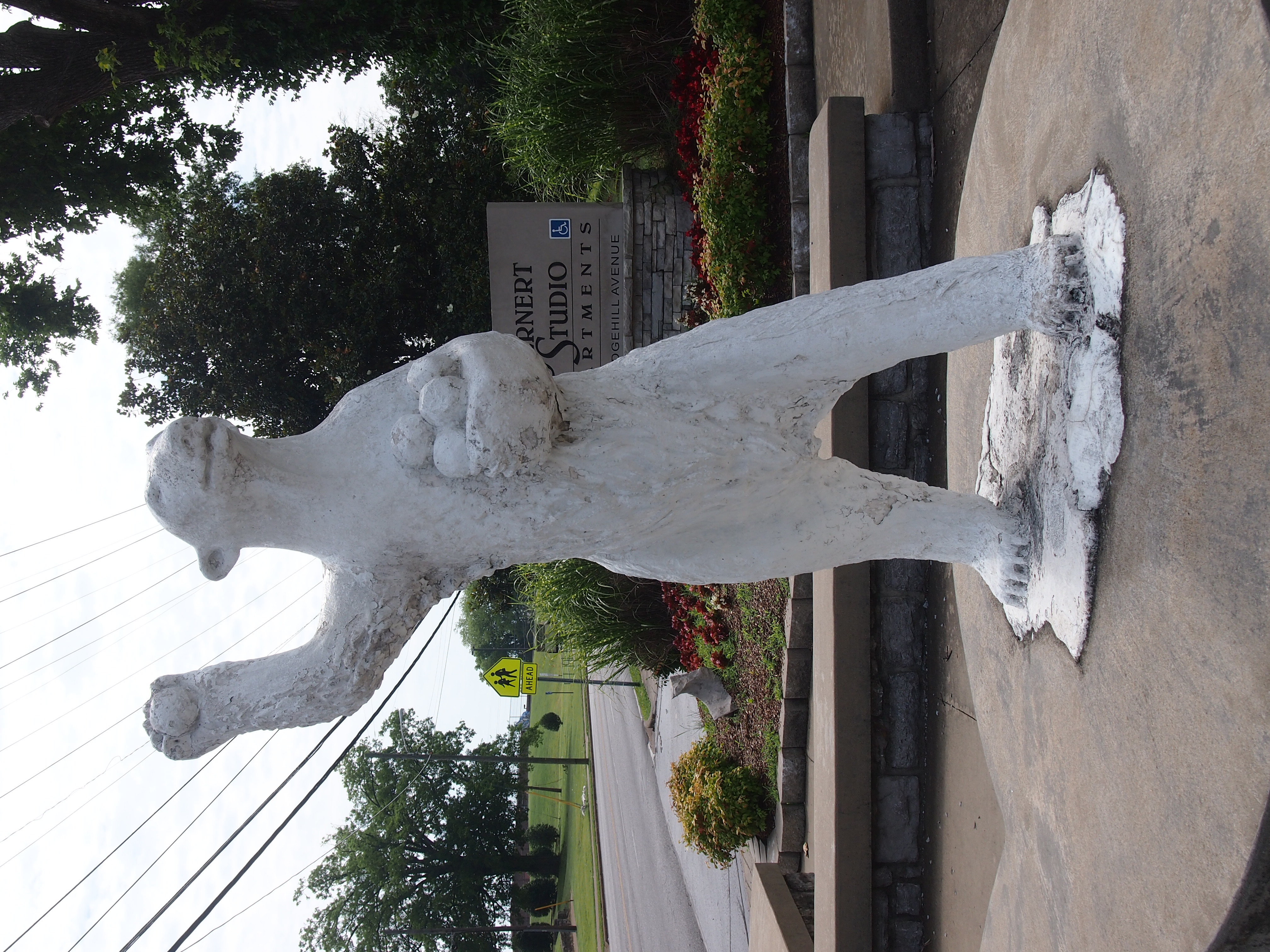
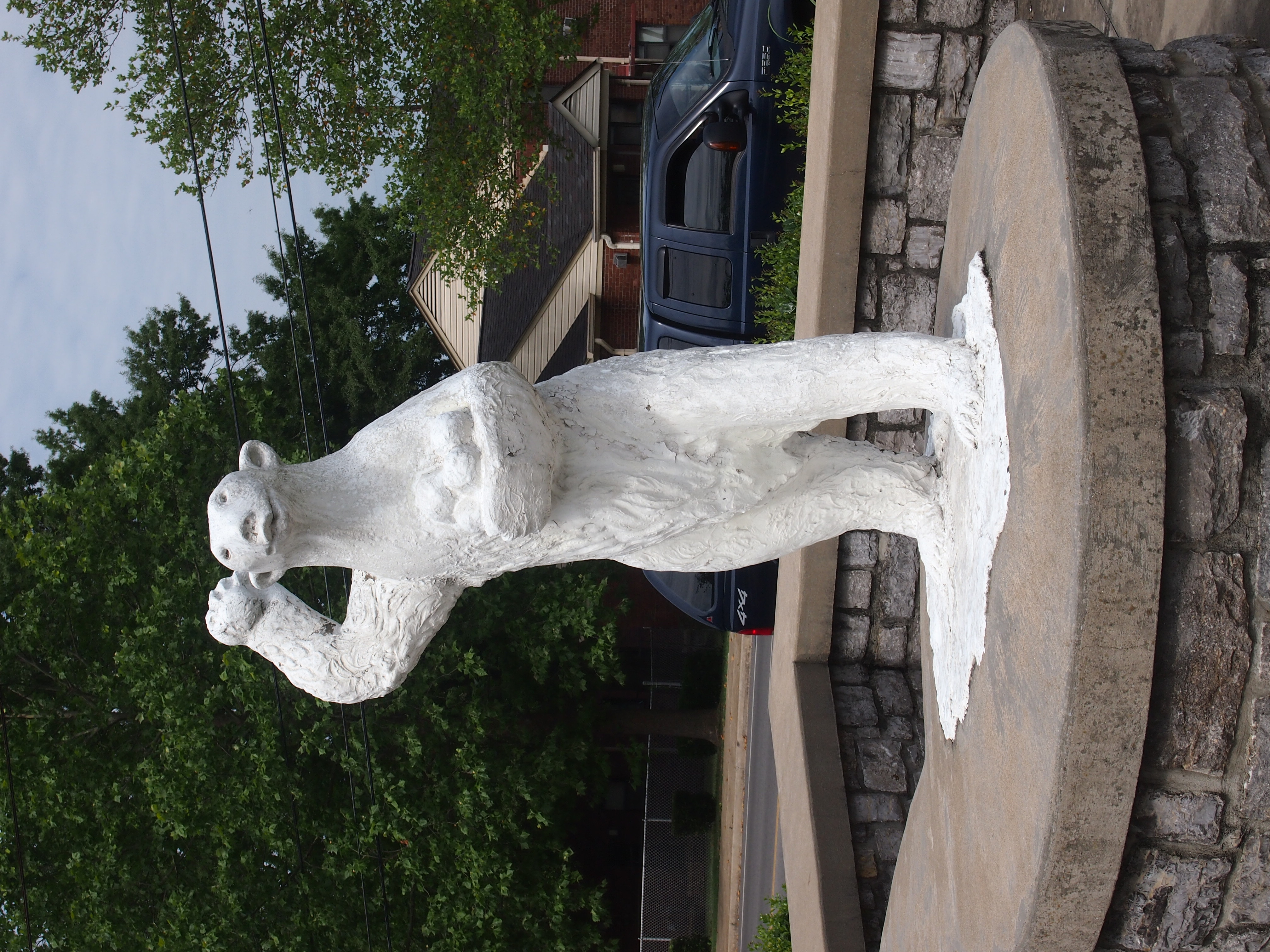
The fate of the funeral home bears remains unknown. The two formerly at 1408 Edgehill – which I used to see frequently, since I lived on Edgehill a few blocks away for a year – are now fixed at the corner of Edgehill and 12th on public property.

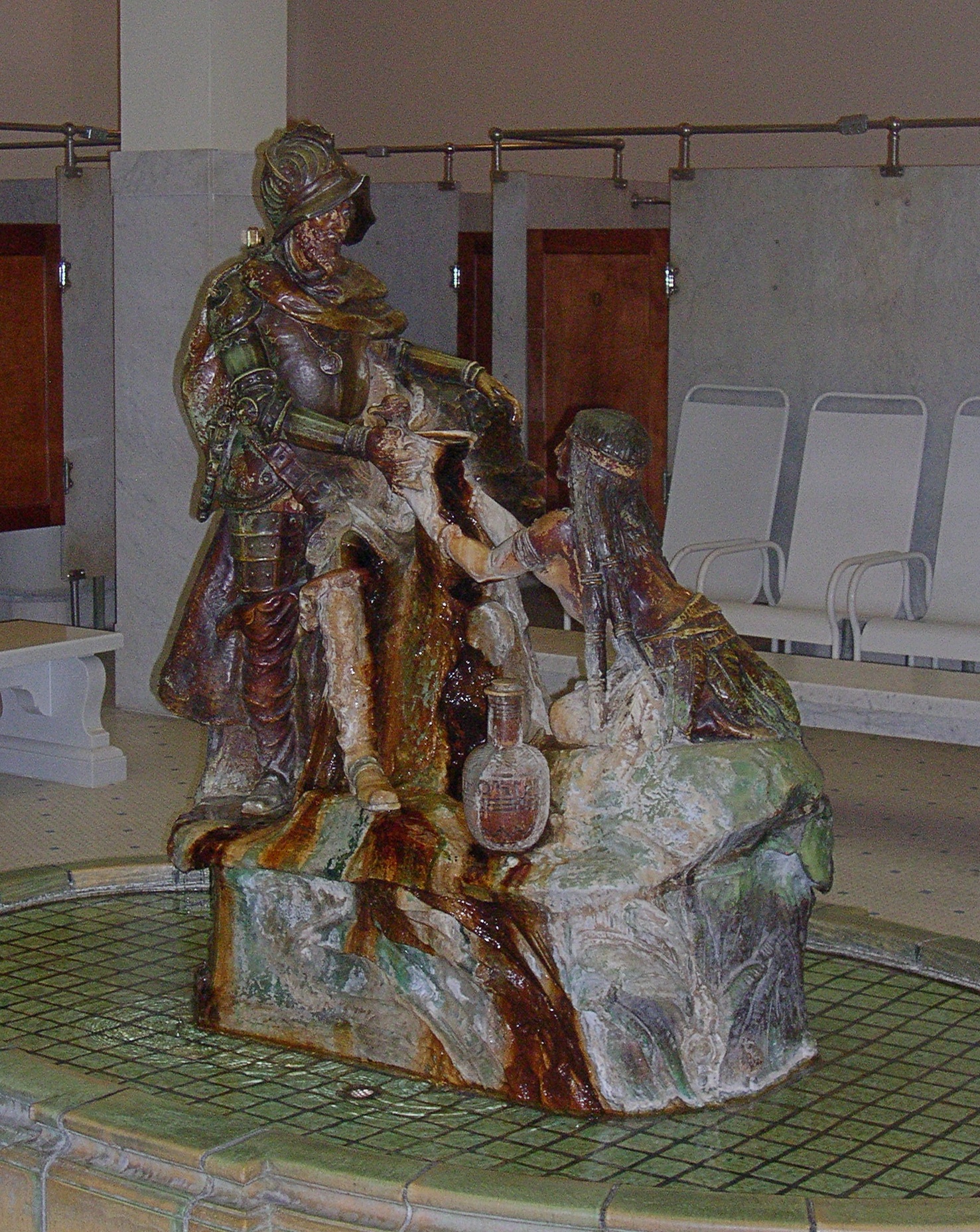
In Memphis, we made a brief stop to look at some other animals. Living creatures this time, the Peabody Hotel ducks. The two on the right are easy to see, but there were a few others on the left of the fountain in the lobby.
Peabody Hotel ducks 2016
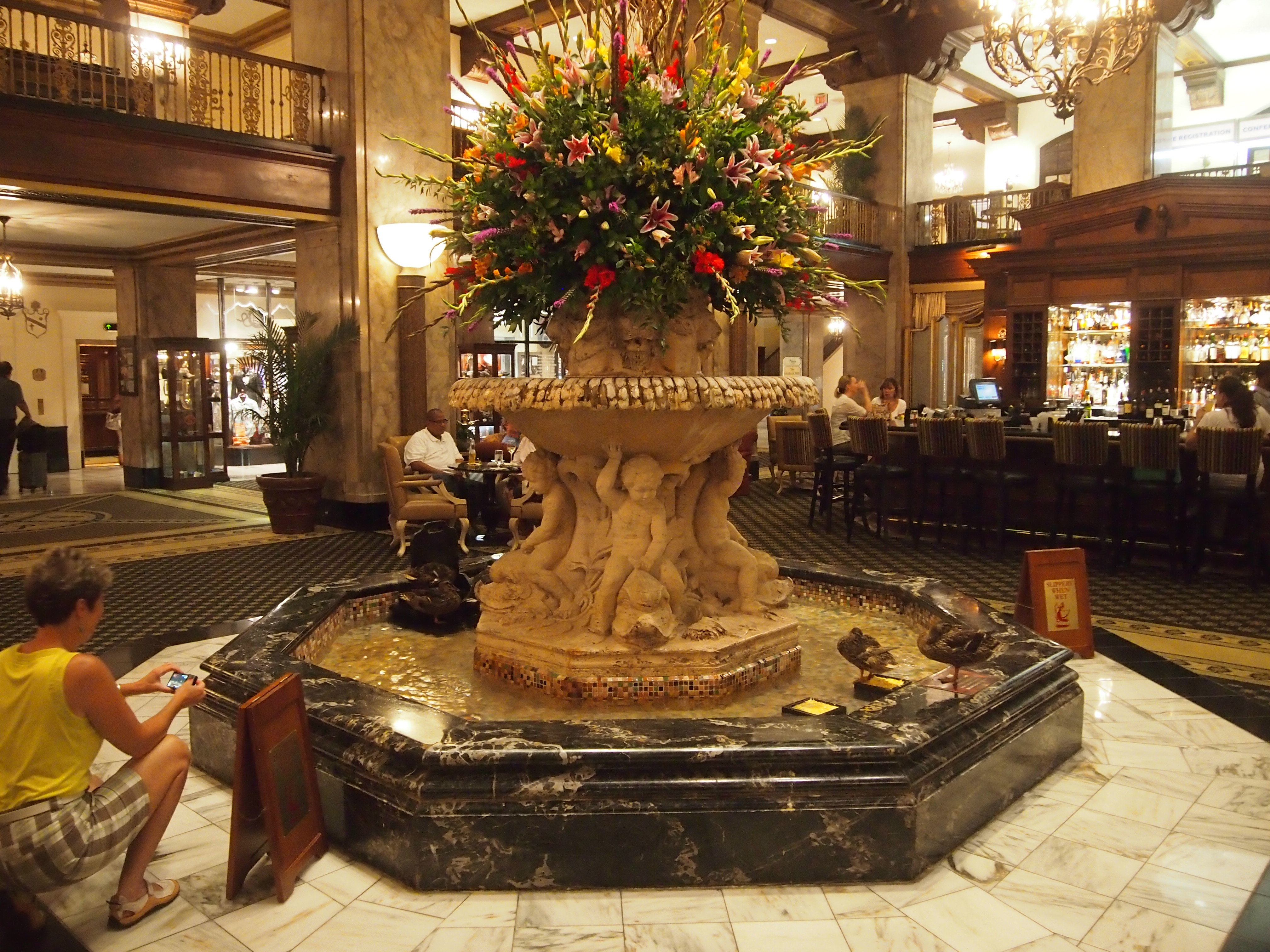
I can’t remember when I first heard about the ducks. Maybe as far back as college. When I knew we’d be passing through Memphis, I checked to make sure they still residing in the hotel lobby fountain. So they are. We didn’t see the ducks march, but we did see the ducks.

“How did the tradition of the ducks in The Peabody fountain begin?” the hotel web site asks, and proceeds to answer with a story that’s a little vague, but never mind: “Back in the 1930’s Frank Schutt, General Manager of The Peabody, and a friend Chip Barwick, returned from a weekend hunting trip to Arkansas. The men had a little too much Tennessee sippin’ whiskey, and thought it would be funny to place some of their live duck decoys (it was legal then for hunters to use live decoys) in the beautiful Peabody fountain. Three small English call ducks were selected as ‘guinea pigs,’ and the reaction was nothing short of enthusiastic. Thus began a Peabody tradition which was to become internationally famous.®

“In 1940, Bellman Edward Pembroke, a former circus animal trainer, offered to help with delivering the ducks to the fountain each day and taught them the now-famous Peabody Duck March. Mr. Pembroke became the Peabody Duckmaster, serving in that capacity for 50 years until his retirement in 1991.”

The hotel, true to modern form, is also quick to point out that “raised by a local farmer and a friend of the hotel, each team of Peabody Ducks lives at the hotel for only three months before retiring from their duty and returning to the farm, where they are free to live as wild ducks… the hotel recognizes its resident waterfowl as wild animals and does not domesticate them or treat them like pets.” Good to know.

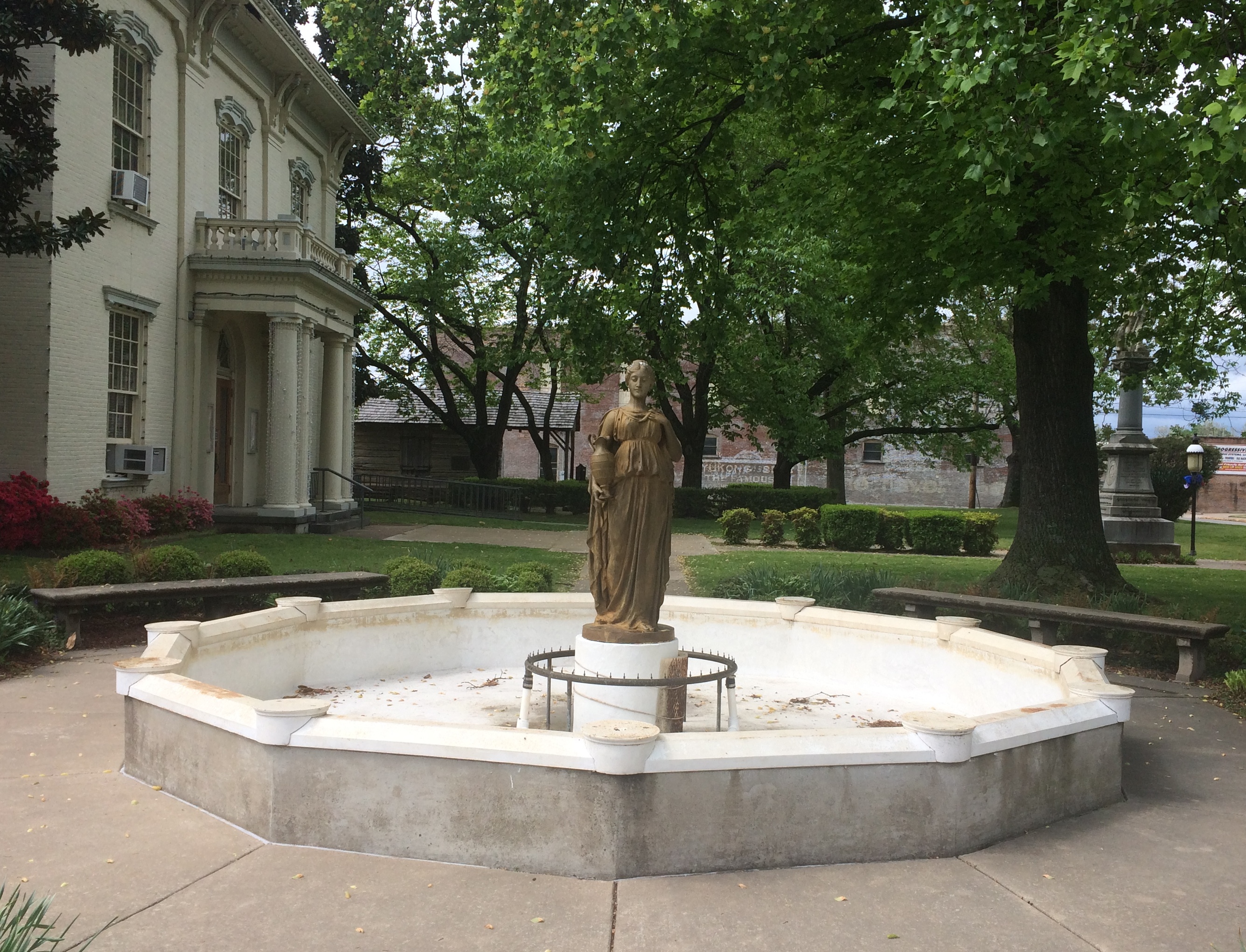
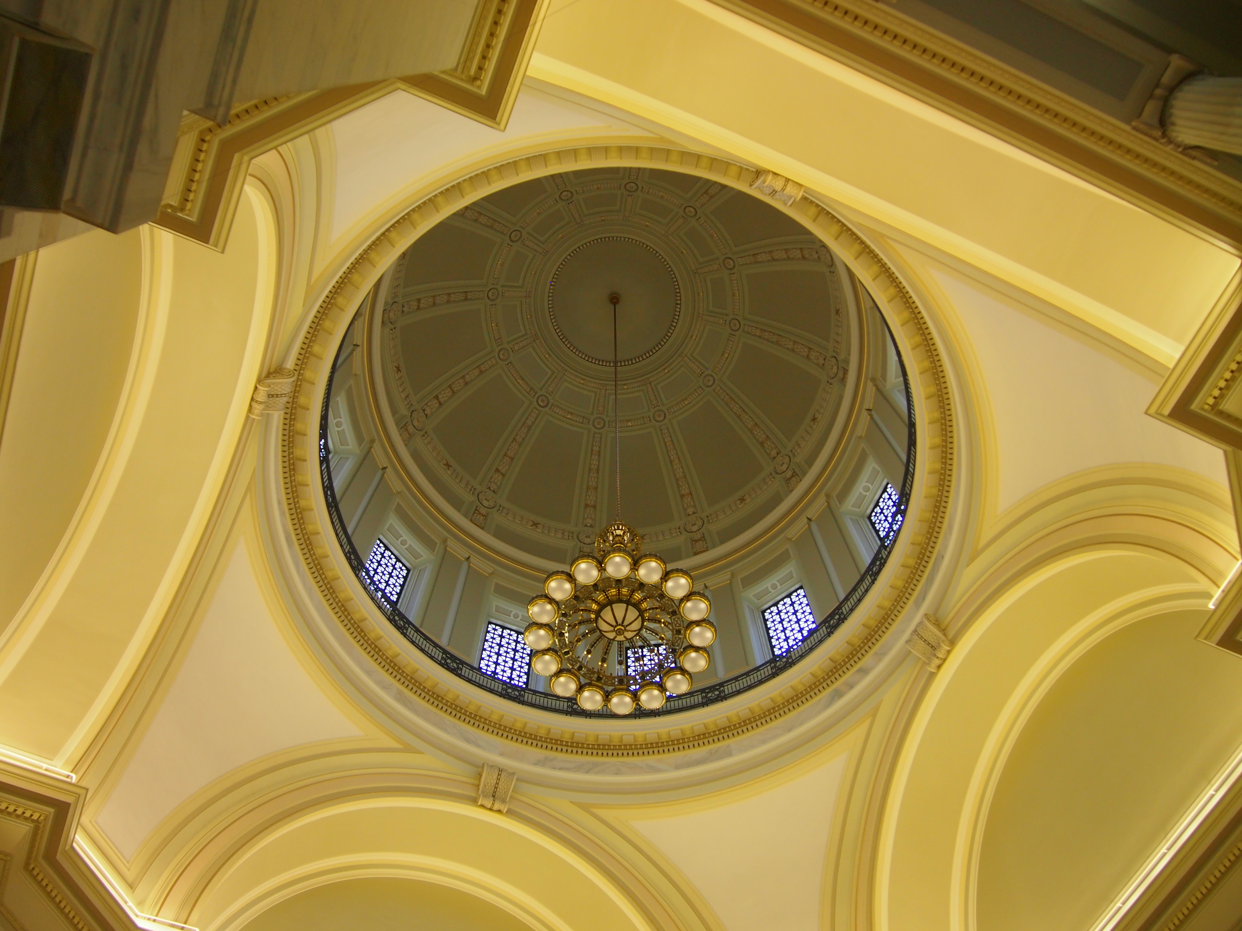
In Little Rock, we visited the state capitol just before we left town.

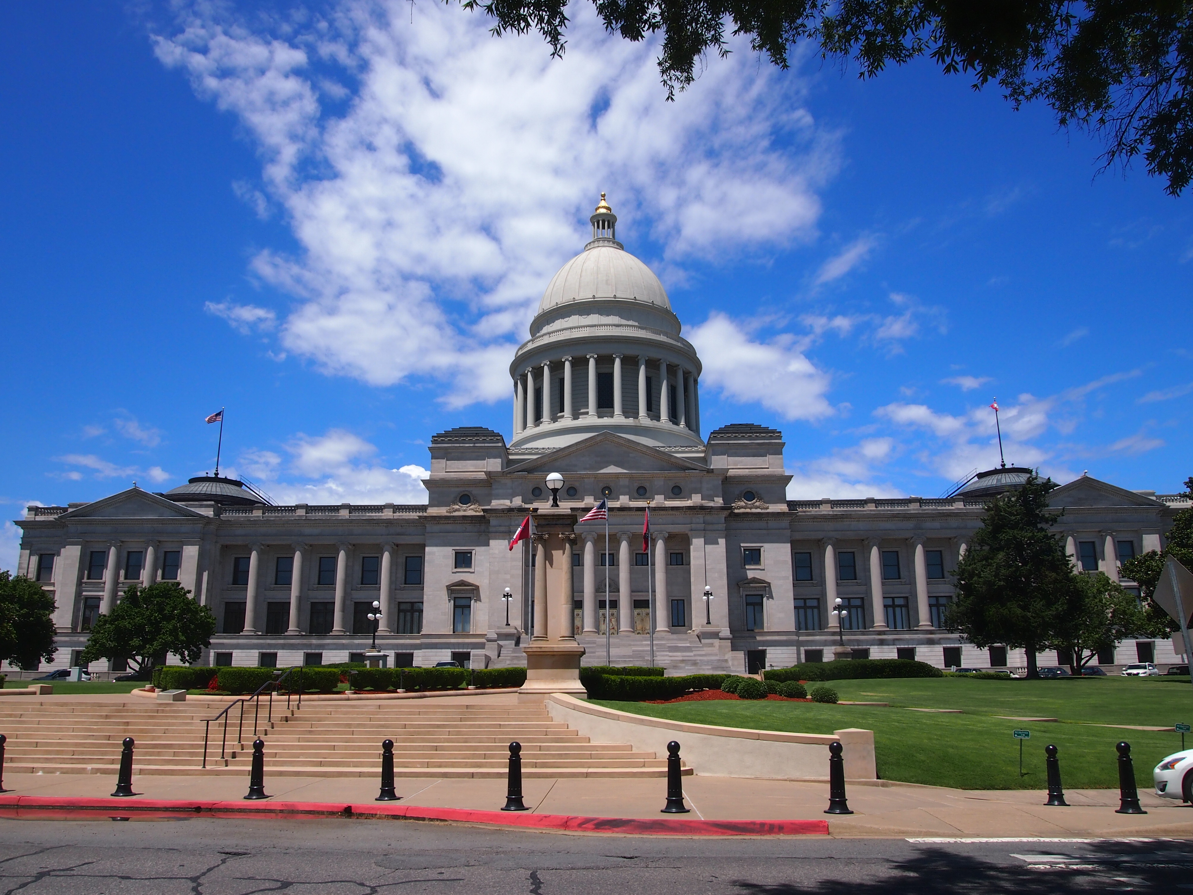
It’s somewhat austere, but I was really taken with the gold-leaf dome interior.
Arkansas State Capitol interior domeThe Cass Gilbert Society notes that “the Arkansas State Capitol, designed and constructed over the course of some eighteen years, was the product of one political investigation, two architects, and three governors…. As executed, the [capitol] is constructed of gray granite with a pedimented entrance section below the dome, flanked by colonnaded wings terminating in pedimented pavilions, each with a shallow dome over the legislative chamber within. The dome rises from a colonnaded drum and is surmounted by a lantern. The building has been characterized as having ‘the transverse stairhalls and the clear articulation in three blocks of Gilbert’s Capitol of Minnesota, but its simplicity is almost raw.’ ”

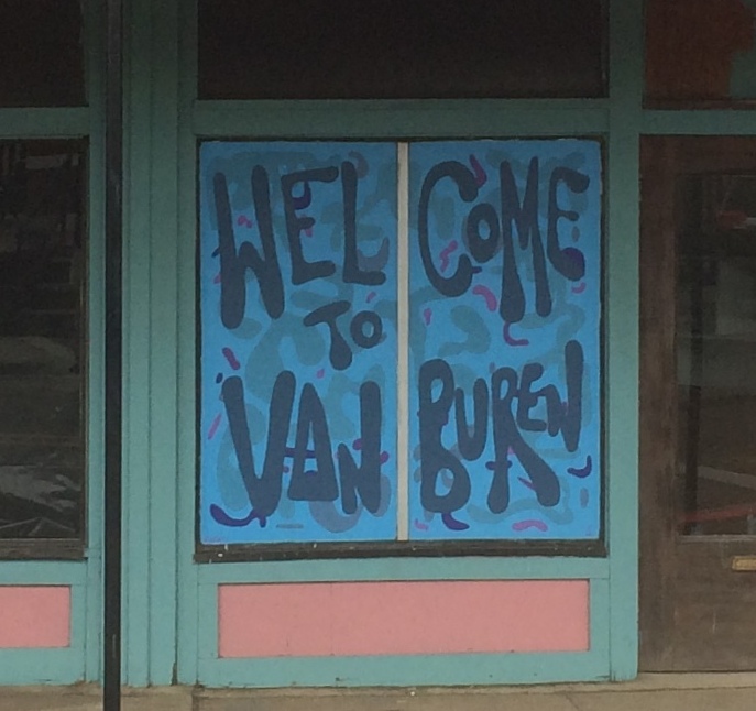
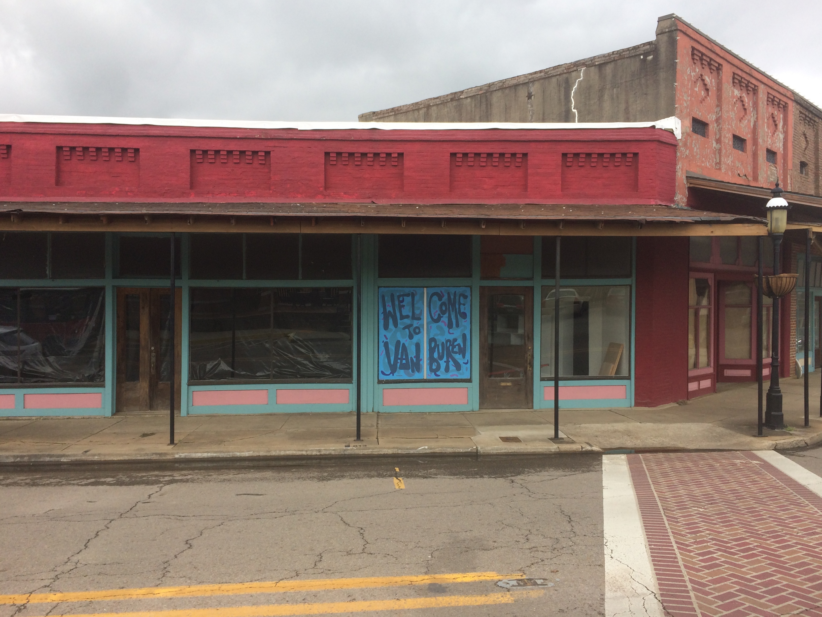
In Texarkana, a place I’d only ever passed through, I decided it was high time to drive down State Line Ave. and visit the Texarkana U.S. Post Office and Courthouse. Here’s a shot of the building I took despite the rain, taken while standing on the border, which is helpfully marked on the pavement. A sign also says the location is at LAT 33 25 29.8 N and LONG 94 02 35.2 W.
US Post Office & Federal Building Texarkana 2016
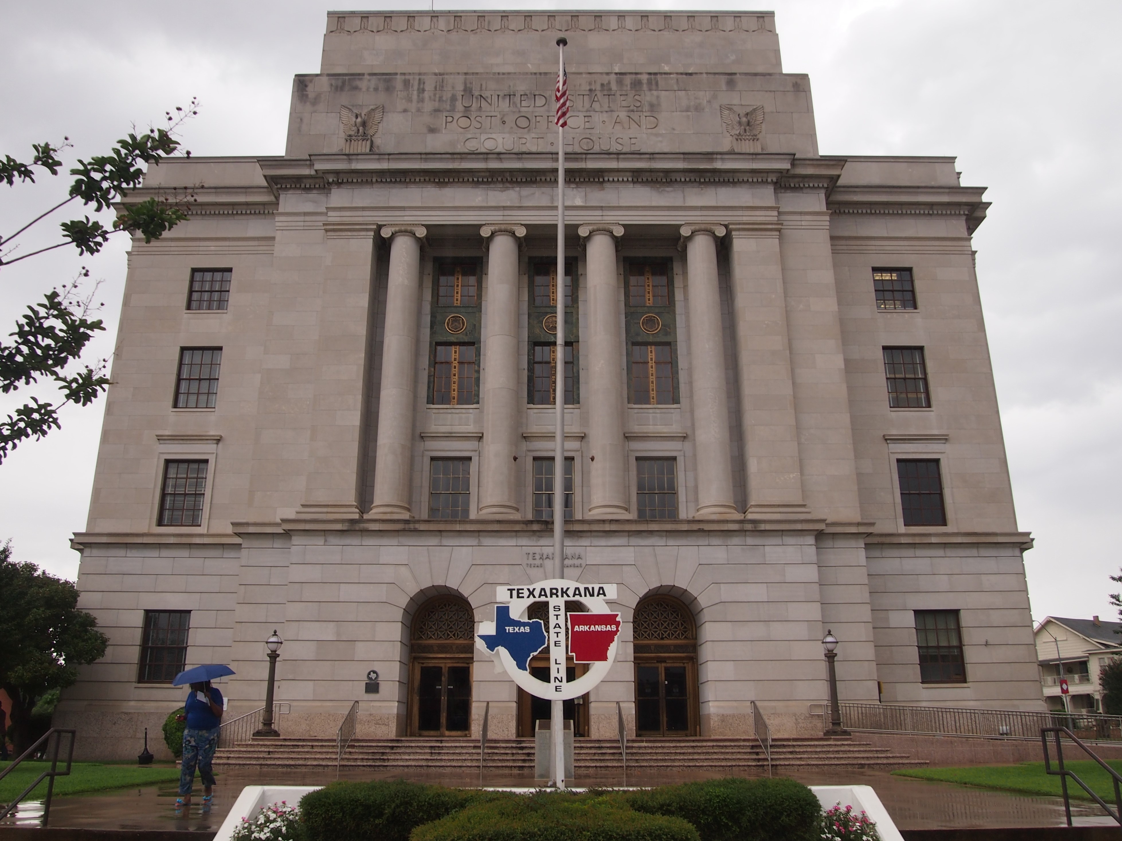
I didn’t need to visit the courthouse, but went through a metal detector on the Texas side and then through a door on the Arkansas side to enter the post office, a wonderful ’30s-style federal facility, complete with brass-plated mail boxes and cages for the tellers. The tellers are on the Arkansas side, the mail slot on the Texas side. I mailed a postcard. Sure, it’s an imaginary line, but I had some fun with it.

One strategy when evaluating online reviews is to toss out the very high and very low ratings, something like in competitive gymnastics. Gushing praise may well be a plant, and shrill invective might be from people who would complain about the seat cushions on a lifeboat. Then read other reviews with some skepticism, but not too much. Pretty much like you’d read anything else.

In this way I decided that the Austin Motel in Austin and the Havana Hotel in San Antonio would be reasonably good places to stay for a few days each. Turned out I was right.

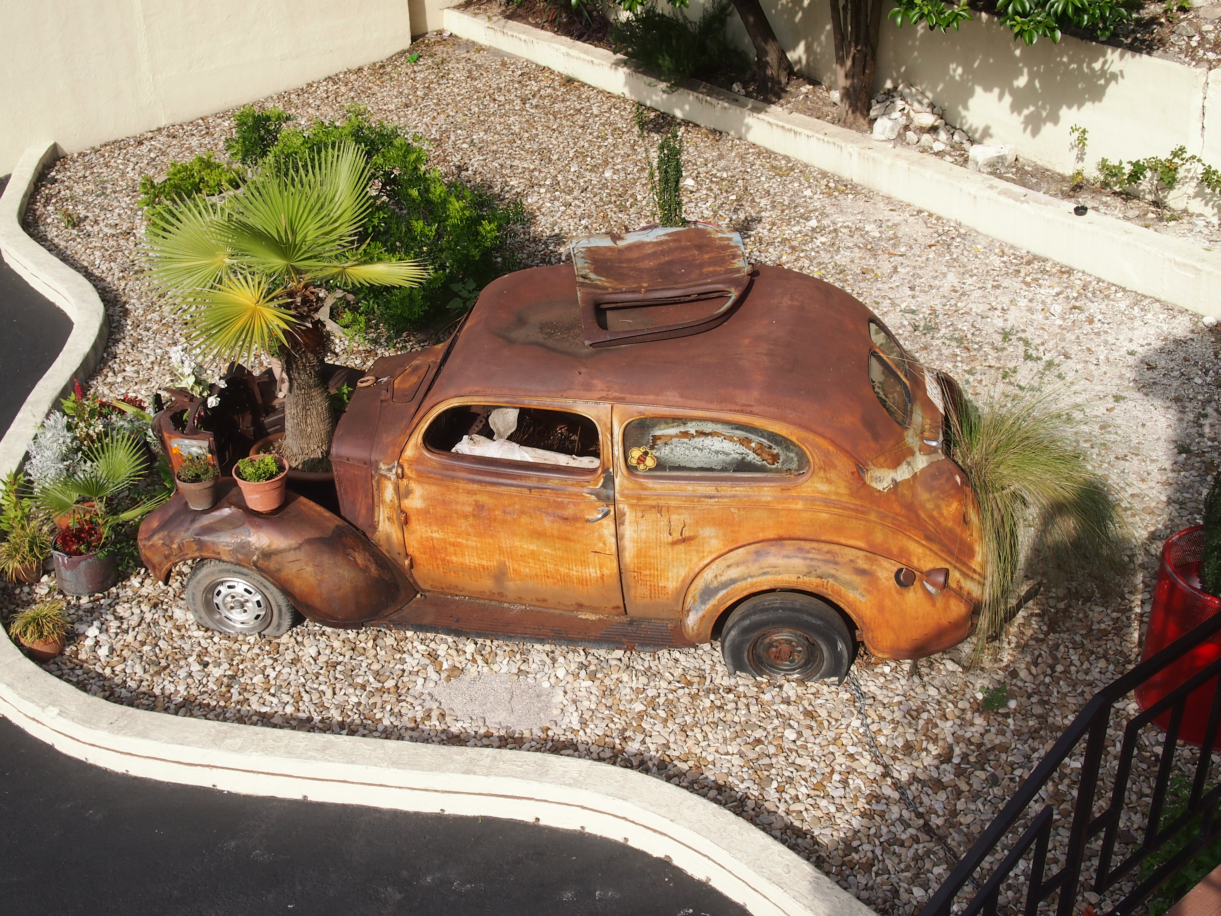
The Austin Motel started off as a tourist court in 1938, and while updated (AC, wifi, that kind of thing), it retains some of the old charm, while not costing the moon despite its popular location in SoCo. Everything was basic, but without some of the petty annoyances motels dish up sometimes, such as a squeaking, rattling, noisy air conditioner. It also had some nice touches: a real key on a brass key ring, for instance, but no bottle opener fixed to one of the room surfaces — it needed that.

The motel also features a rusting shell of a car next to its parking lot, vintage late ’30s, now the centerpiece of what looks to be a xeriscape.
Austin Motel rusty car
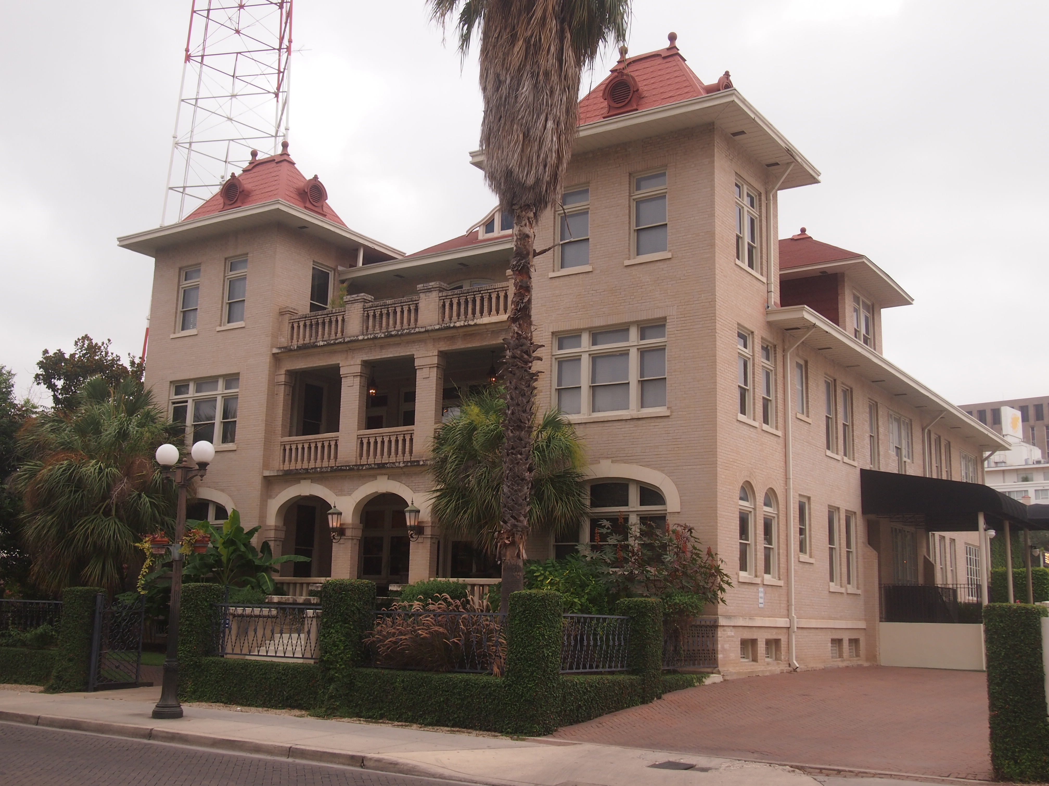
The Havana Hotel has a nice location in downtown San Antonio, near the Riverwalk and the Tobin Center. The property started as a company hotel in 1914 and while modernized (you know, AC, wifi) retains many of the charms of the original design, such as high ceilings and dark woods. Though a little more expensive than the Austin Motel, you got a little more, such as a hip Italian SMEG refrigerator in the room.

Hotel Havana, San Antonio 2016One more thing: the Greetings From Austin mural off funky 1st St. “On the southern exterior wall of Roadhouse Relics, this mural first adorned the neighborhood business in 1998,” writes Cris Mueller in Austinot. “Artist and owner Todd Sanders and his friend Rory Skagen recreated this iconic Austin postcard on the side of the building to add light to a neighborhood that, at the time, was taking a turn for the worst.”

It was renovated in 2013 and looks pretty fresh. Roadhouse Relics, incidentally, sells neon signs. How very Austin.
Welcome to Austin mural 2016
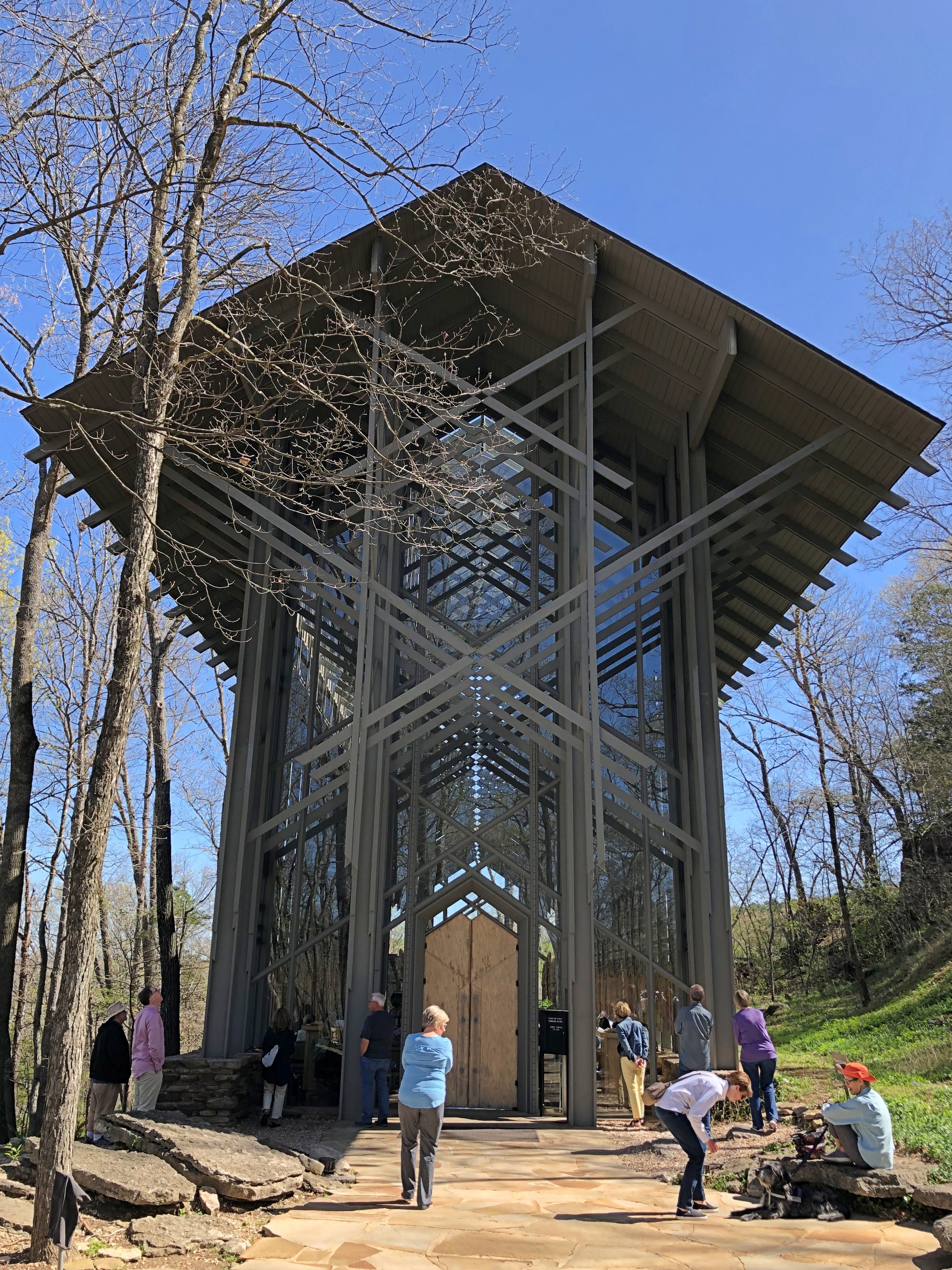
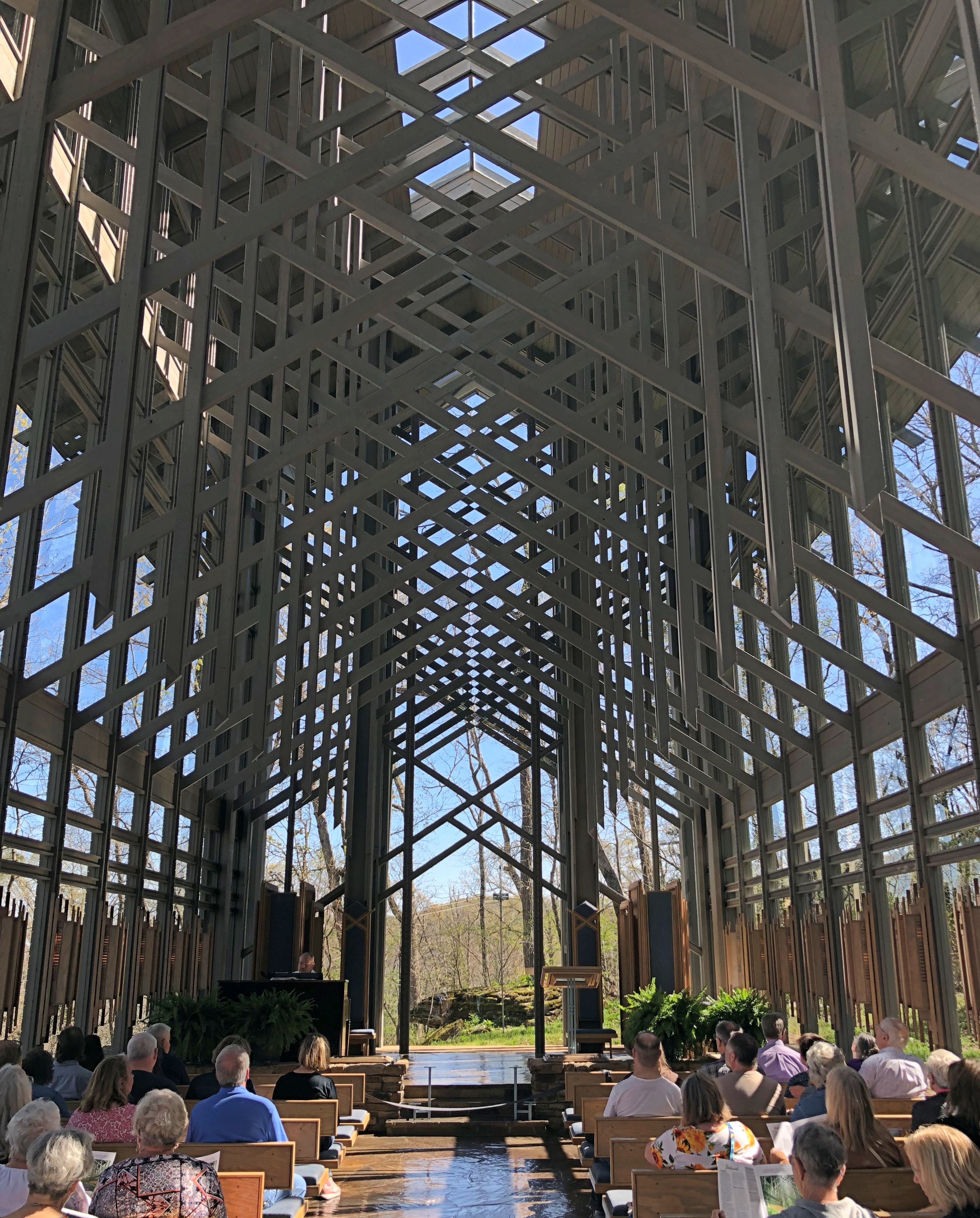
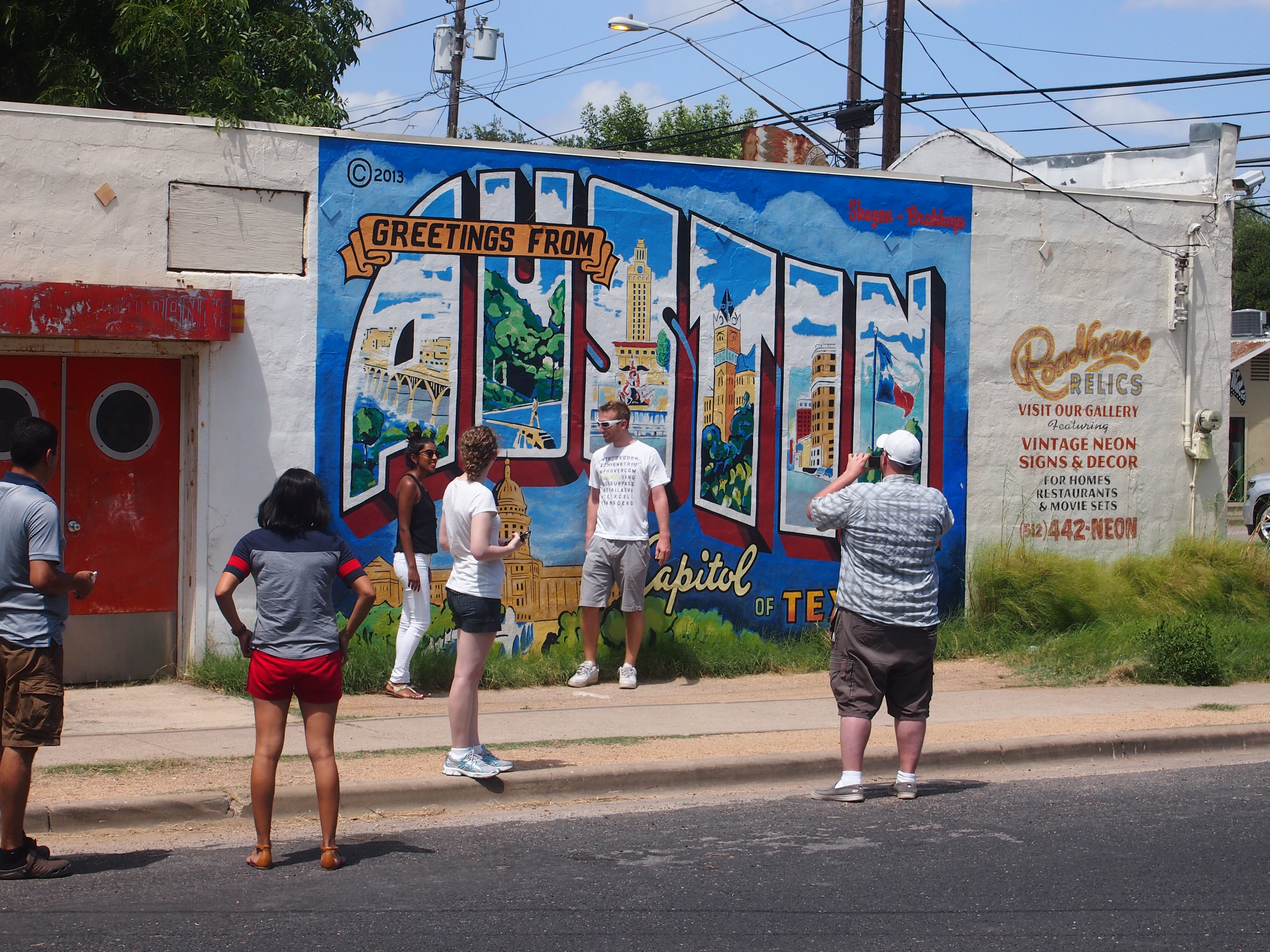
I could have waited until the people had cleared away, but what good would that be? People make the shot more interesting.

The William J. Clinton Presidential Center and Park

The museum building of the William J. Clinton Presidential Center and Park in Little Rock cantilevers over the south bank of the Arkansas River. Hope the structural engineer planned for events like the next major movement of the New Madrid Fault.The William J. Clinton Presidential Center and ParkOn June 27, after seeing the Mount Holly Cemetery, I drove over to the presidential library by myself, not wanting to subject Ann to another museum just then. All I had to do was make it back to the hotel room in time to pack before checkout time. The facility is one of 13 presidential libraries/museums run by the National Archives and Records Administration; now I’ve been to eight of them, nine if you count the Eisenhower Library, which I’ve been told we visited when I was small.

So I know what to expect: a museum that puts the best face on whichever administration it’s about, regardless of party or historic circumstance. Keep that in mind, and no presidential library will drive you to distraction because of your opinion about this or that president. You can have fun with it, though, imagining exhibits that will never happen, such as I AM NOT A CROOK carved over the entrance of the Nixon Library or an animatronic Monica Lewinsky at the Clinton Library.

Polshek Partnership designed the property (these days, Ennead Architects), with the exhibition design by Ralph Appelbaum Associates. According to sources inside and outside the exhibit hall, the space was inspired by the Long Room in the Old Library at Trinity College, Dublin. I haven’t seen the Long Room, but the exhibit hall of the Clinton Library certainly is long, as you’d expect looking at it from the outside.
The William J. Clinton Presidential Center and ParkThe exhibits are a mix of photos, reading and artifacts, mostly in chronological order down the length of the second floor, and on the third floor as well, as well as in 14 alcoves detailing various events during Clinton’s terms of office. As I’ve mentioned before, it’s a little hard to view a period as history when you remember it as an adult. Then again, he’s been out of office 15 years, and the early years of the Clinton administration especially are a little fuzzy, since I was still out of the country.

The blue boxes — 4,536 in all, according to the museum — contain records from the White House Office of Agency Liaison, which deals with requests to the president or first lady from the public. “The records in these blue boxes represent approximately 2-3% of the entire Clinton Library archival collection, which we estimate at approximately 80 million pages.”

Among the artifacts on display: saxophones. Jefferson had his violin, Truman had his piano, and Clinton had his sax (and I’ve read that Chet Arthur played banjo; just picturing that makes me smile).

The William J. Clinton Presidential Center and ParkSomething unexpected on display was a Chihuly, “Crystal Tree of Light,” one of two works the artist did for White House celebrations on December 31, 1999. Always good to happen across a Chihuly.

The William J. Clinton Presidential Center and Park - ChihulyThe museum also sports a replica Oval Office, designed to look like it did in the ’90s. Every presidential museum worth its salt has an oval office. This one has the distinction of being full-sized.
The William J. Clinton Presidential Center and Park - Oval OfficeThe full name of the facility refers to a park as well, and indeed it includes land along the Arkansas River. Best of all: there’s a nearby former railroad bridge, fully renovated and open for pedestrian and bicycle traffic since 2011.
The William J. Clinton Presidential Center and Park - railroad bridgeThe Choctaw, Oklahoma & Gulf RR built the bridge in 1899. That’s a railroad I’d never heard of, and for good reason, since it was swallowed by the Chicago, Rock Island and Pacific RR by 1904. After all, the Rock Island Line is a mighty good road, the Rock Island Line is the road to ride.

It’s a fine 19th-century work of iron, but even so illuminated by large 21st-century LED lights.
The Rock Island Line is a mighty good road The Rock Island Line is the road to rideBy the 1990s, the 1,600-foot structure had long since passed out of service as a railroad bridge, and was going to be dismantled. Instead, the City of Little Rock took possession, to make it part of a system of trails along the Arkansas River.

The bridge offers a nice view of downtown Little Rock.
Little Rock SkylineAnd the river.
Arkansas River - Little RockAll in all, it’s a good location for a presidential library. It isn’t crowded in by urban or suburban surroundings, like most I’ve seen, though Hoover’s is in a distinctly rural setting.