I was looking in a seldom-looked at file of images the other day and found a scan I’d made of a page from a collection of Thomas Jefferson’s writings. I’d forgotten I’d made ir. Here it is.
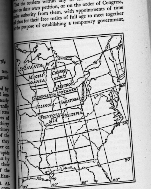
Nearly 15 years ago, I wrote: “Some years ago, I read a curious little document by Thomas Jefferson, who in 1784 made a report to Congress — the Congress under the Articles of Confederation — about how to create states from the Northwest Territory and what to call them.
“Jefferson suggested 10 states for the area that now contains six (Illinois, Indiana, Kentucky, Michigan, Ohio and Wisconsin). It was an exercise in hyper-rationality and hyperliteracy, though if his suggestions had been used, they would be normal and even venerated names — such is the power of custom.
“Hyper-rational because, instead of paying attention to natural features, Jefferson cut the district into rectangles measuring two degrees of latitude north-to-south and roughly four degrees of longitude east-to-west (‘roughly’ because the irregular Mississippi River forms the western boundary of the territory).
“Besides the Mississippi, geographic form did intrude in what we call lower Michigan — even Jefferson wasn’t going to ignore lakes Michigan and Huron in drawing lines — as well as a few other places on his map, but he was doing his best to apply Longitude and Latitude to the new states’ boundaries. It was as if Colorado- and Wyoming-shaped states were to be created in the Midwest.”
Naturally, other sites discuss this odd collection of non-realized states, such as (of course) Strange Maps.