I have in my possession a Handy Map of London. This is supposedly a German version of similar vintage; mine is in English, but it looks just the same. Mine is dated 1986, so I’m certain I picked it up in 1988.
It isn’t my favorite map of London — that would be that marvel of aesthetic mapmaking, the Bensons MapGuide.
Still, the multi-page, folding Handy Map, published by John Bartholomew & Son Ltd. of Edinburgh, was indeed handy. That company, long since a unit of Harper Collins, is one of the storied Scottish mapmakers, as detailed here.
Interesting material in the Wiki description, though without citation: “John Bartholomew Junior was credited with having pioneered the use of hypsometric tints or layer colouring on maps in which low ground is shown in shades of green and higher ground in shades of brown, then eventually purple and finally white.
“It is his son John George who is attributed with being the first to bring the name ‘Antarctica’ into popular use as the name for the Southern Continent, and for the adoption of red or pink as the colour for the British Empire.”
By gar, someone invented those conventions. But they’re such strong conventions that you hardly think of a time when maps didn’t feature them.
The Handy Map folds out to reveal ten separate maps, nine of which are parts of Greater London, and all of which are color- and number-coded. Want to look for a particular place? The map makes that pretty easy. Even more so than Benson, I have to say.
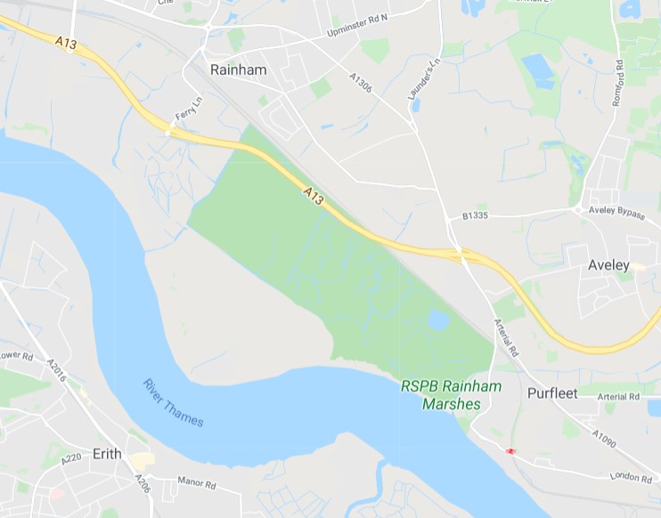
The tenth map is a view of all of Greater London. As you’d imagine, it can’t be overly detailed, but it is good for orientation. I was looking at it the other day (for now the Handy Map is in the downstairs bathroom) and noticed an oddity on the Greater London map.
Toward the eastern edge of the map, just north of the Thames near a place called Purfleet, is a pink, long oval shape (like a race track) simply marked DANGER AREA.
What? It took me a few days to remember to check it out on Google Maps. In 1986, a danger area. In 2020, it’s the RSPB Rainham Marshes, also known as the Rainham Marshes Nature Reserve.
 That would be, according to Google: “Bird-rich former marshland firing range with accessible boardwalks and a modern visitor centre.”
RSPB? The Royal Society for the Protection of Birds. The organization bought the land from the UK Ministry of Defence in 2000, opening it to the public in 2006. So danger area no more, unless you’re attacked by cetti’s warblers, little egrets or peregrine falcons. More about the marshes is here.
More about the organization is here.
“The RSPB was formed to counter the barbarous trade in plumes for women’s hats, a fashion responsible for the destruction of many thousands of egrets, birds of paradise and other species whose plumes had become fashionable in the late Victorian era,” its web site says.
“The organisation started life as the Society for the Protection of Birds (SPB), founded by Emily Williamson at her home in Manchester in 1889. The group quickly gained popularity and in 1891 it merged with the Fur, Fin and Feather Folk, to form a larger and stronger SPB, based in London.
“In its earliest days, the society consisted entirely of women and membership cost twopence. The rules of the society were:
“That members shall discourage the wanton destruction of birds and interest themselves generally in their protection
“That lady-members shall refrain from wearing the feathers of any bird not killed for purposes of food, the ostrich only excepted.”
Interesting that ostrich feathers were OK. If I felt like it, I could investigate why that was, but I have a hunch that ostrich farming was entirely too valuable before WWI to discourage, especially in South Africa. These days, leather is the main thing, with feathers just a sideline.