Milwaukee Doors Open ’17

Temps have cooled down some, but it’s still warmer than usual for this time of year. At about 12:30 this afternoon, I saw an ice cream truck drive down our street. I can’t ever remember seeing one in October.

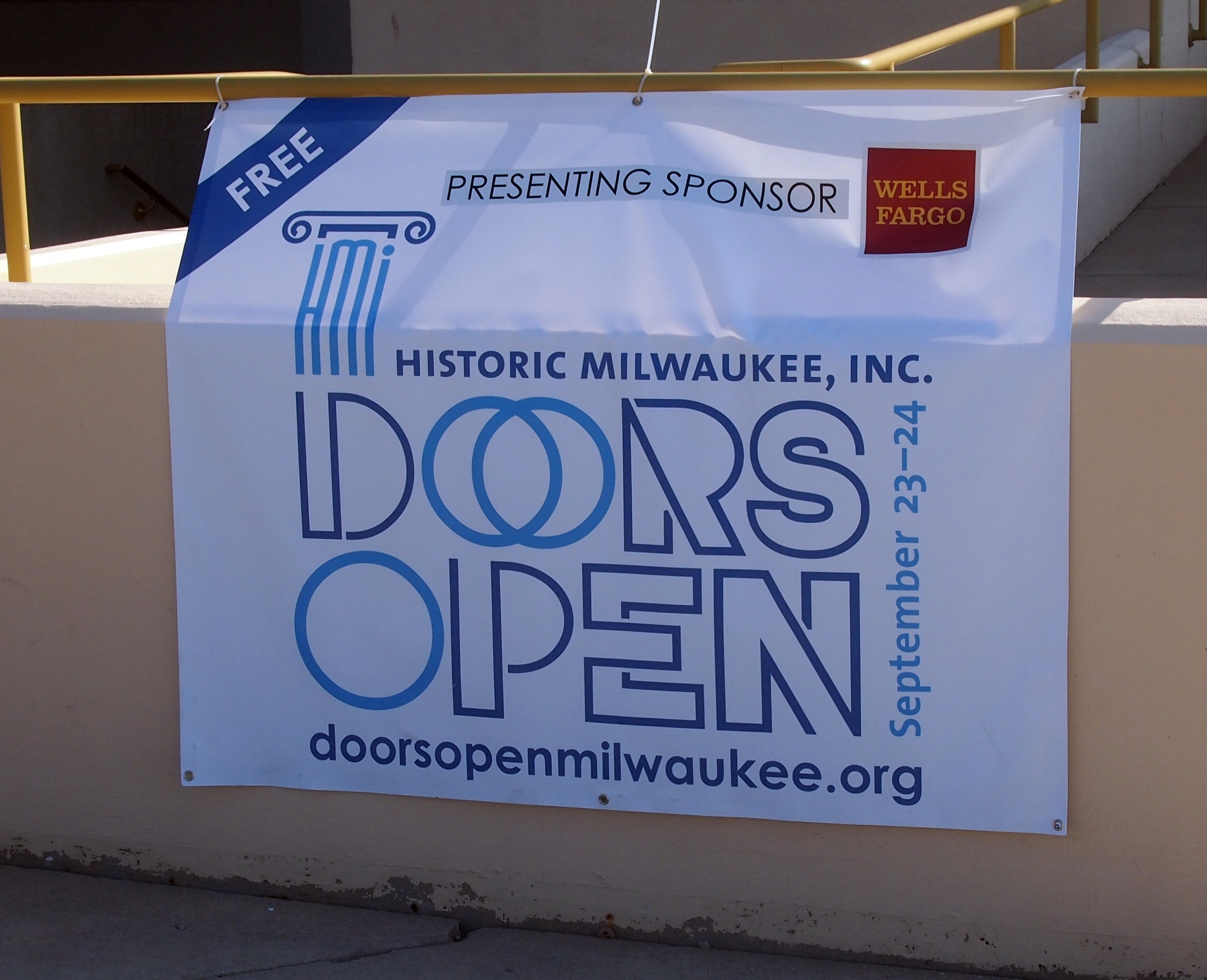
Last weekend, Yuriko and I drove up to Milwaukee to participate in Milwaukee Doors Open. Ann couldn’t make it, even if she’d wanted to, because she was attending her first high school speech tournament.

That’s a good thing. Her joining speech inspired me, while in Texas recently, to open up one of my high school yearbooks, the 1979 edition, to the page devoted to the National Forensic League. I was a member.
NFL AHHS 1979I discovered when Ann signed up for debate that it isn’t the NFL any more, but the National Speech & Debate Association, only since 2014. What kind of name is that? Hopelessly bland. It’s as distinctive as the name of a suburban office park in a mid-sized market.

Note in the picture above: the club’s officers (I was one of those, too) had fun with belonging to the NFL. We lined up like football players for the picture.

Doors Open Milwaukee 2017First we went to Annunciation Greek Orthodox Church, which is in the near suburb of Wauwatosa. It’s best known for being one of Frank Lloyd Wright’s last works, and in fact was completed after he died. As I read, and as I saw, this 1950s church is informed by traditional Byzantine forms. But I also couldn’t help thinking of space age forms.

From there, we went into the city and revisited the Basilica of Saint Josaphat. Last time we were there was Good Friday 2011, and as you’d guess, the church was fairly busy that day. This time, it was open just for a look, so we were able to do that at some length.

East Town, the part of downtown Milwaukee east of the Milwaukee River, was next. A number of churches along or near Juneau St. were open, so they became the focus. Doors Open features a lot more than churches, but with so many clustered together, I figured that would be a good theme for this year.

They included All Saints’ Cathedral (Episcopal), Summerfield United Methodist Church and Immanuel Presbyterian Church. All were worth seeing.

At one of them, a U.S. flag and another flag graced the entrance. The other one, which I’d never seen before, intrigued me. Y held it so I could take a picture, since the wind wasn’t up.
The People's Flag of Milwaukee
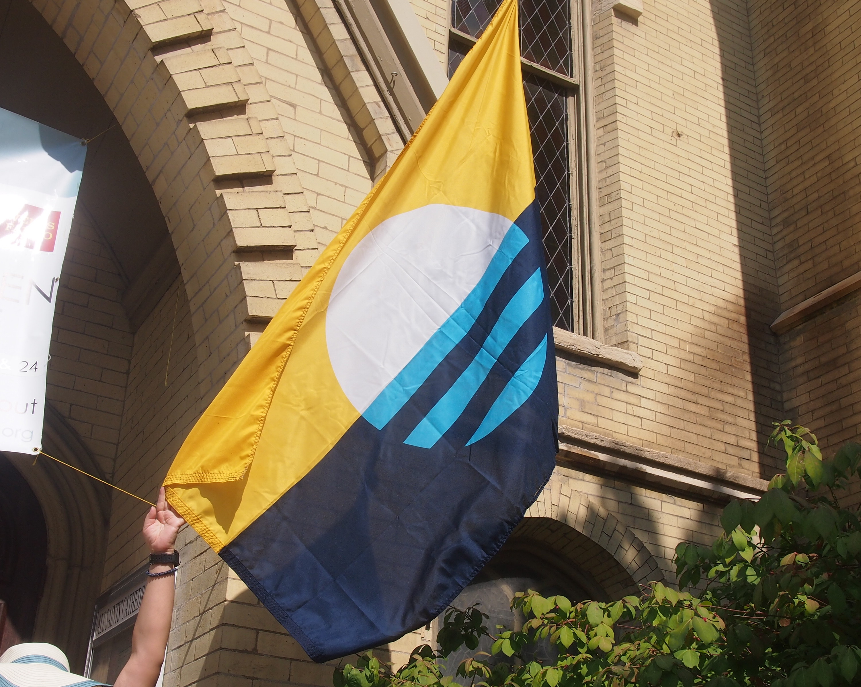
I asked the volunteer inside the door about it, and she told me it was the new flag of Milwaukee. I took that to mean officially, but that’s not so. There’s a movement to make it the official flag, to replace this embarrassment, but it hasn’t happened yet.

Currently it’s the People’s Flag of Milwaukee. Sounds like the banner under which the proletariat would storm City Hall, but I don’t think the organizers of online poll to pick a new design had that in mind. I’ll go along with it, though I don’t live in Milwaukee. It’s a good design. Vexillologists hate the current flag, and I agree with them.

Speaking of Milwaukee City Hall, that was the last place we went for Doors Open Milwaukee after a late lunch at the downtown George Webb, the local diner chain with two clocks. I interviewed the mayor of Milwaukee in his office at City Hall in 2003, but I really didn’t get to look around. It’s a splendid public building, dating from the Progressive Era.

Thursday Odd Lots

“What’s so funny, Dad?”

“That sign across the street.”

We were in Wisconsin during our recent trip, and had stopped at a place where I could access wifi. The sign was visible from there.

“That’s not funny.”

“Maybe it will be for you someday.”

What would happen if you used this granite for landscaping? Would your back yard suddenly cause you dread? Kafkaesque landscaping, now there’s a concept.

Looks like Kafka does some good work, though.

Here’s a sign you don’t see much any more, though I’m pretty sure that they were common once upon a time. I think even my high school cafeteria, which was in a basement, had one in the late ’70s. They’re so rare now that when you do see one in situ, you take note. Something like a working public pay phone.

Fallout Shelter Sign, Calumet, Michigan

This one is on Sixth St. in Calumet, Michigan. It even has a capacity number. What was once an unnerving reminder of the nuclear Sword of Damocles can now “add a cool tone to a man cave or retro game room,” according to Amazon, where you can pick a reproduction up from the Vintage Sign Co. for (currently) $18.99. The note also calls the item a “vintage style WWII metal sign.” What is it about basic chronology that flummoxes so many people?

Something else I saw, a little more recently, in Bucktown.

Bucktown, Chicago Shiva Shack

Shiva Shack? C’mon in for a bit of destruction and then transformation.

Also in Bucktown: a game of beanbag on the sidewalk.

Bucktown 2017

Maybe there to remind us what politics ain’t.

Recently I picked up The Happy Isles of Oceania (1992) by Paul Theroux. It’s been sitting on my shelf for a number of years. So far it’s a good read. I understand that he has a reputation as a snob, and some of that comes through in his writing, but I don’t know the man personally, so I wouldn’t have to put up with him anyway.

He writes well, at least about the places he’s been, and that’s all that counts. His description, early in the book, of hiking on the South Island of New Zealand, is a fine bit of work, and had the unfortunate side effect of making me want to drop everything and go do that. The mood passed.

Theroux’s work did influence me to go one place. In the early ’90s, I read his Sunrise With Seamonsters, a collection of essays and travel bits, and one piece included a mention of the Cameron Highlands on the Malay Peninsula. It’s a former British hill station, more recently a getaway place for Malaysians and the trickle of tourists who’ve heard of it. His mention of it was probably where I first heard of the place.

When I went to Malaysia for the first time, I made a point of going there, and did not regret it. Besides cool temps, you can enjoy jungle walks (unless you’re Jim Thompson), a butterfly garden, a nighttime view that can include the Southern Cross, and eating Chettinad cuisine on a banana leaf, with your hands.

This is what life is, according to the song.

Life's a Bowl of Cherries

Rainier cherries, which are in season now. Very popular around the house, and we buy them in large quantities while we can. I’m glad that there are still some foods, some fruits, that have a season.

I’m not all that keen on Rudy Vallee, but his version of the song is good. And the lip sync from Pennies From Heaven (1981) is amusing. I saw that movie when it was new, probably because Steve Martin was in it, but I don’t remember very much about it. Maybe I should watch it again. I know I was too young then to appreciate its songs.

Roadside Wisconsin, Part 3: Ella’s Deli, Madison

It’s Space Exploration Day. Always a good thing to think about.

Ella’s Deli in Madison, Wisconsin, is on E. Washington Ave. If you’re driving on that street, it’s hard to miss.

Ella's Deli, Madison, WisconsinElla's Deli, Madison, WisconsinWashington Ave. happens to be a good way to get from I-90/I-39, which runs east of Madison, into the city. Right into downtown, in fact: straight to the capitol, the university, the lakes, and so on. Over the years I’ve noticed Ella’s as I passed by, but never stopped. This time, I drove on Washington Ave. specifically to get there.

A bit from Ella’s web site: “In the early 1960s Ella Hirschfeld owned and operated Ella’s on State Street as a small kosher style deli/grocery/restaurant. At that time Ella’s provided an outlet for the Jewish community and others to buy kosher products over the counter, as well as offering restaurant service for about a dozen tables.

“In 1976, Ella’s opened another location, thanks to the support of Madison’s community… In recent years, Ella’s Deli on East Washington Avenue became the only Ella’s Deli.

“Under the same ownership for over 45 years, Ella’s operates with in-house bakers, full-time cooks that prepare our foods from scratch, and animations designed and built on the premises.”

It was a good choice, both as a place to eat, and a place to see odd things. For instance, a robot-like entity meets you inside the door.

Ella's Deli, Madison, Wisconsin

The restaurant doesn’t exactly have a theme, though I’ve seen it referred to elsewhere as “a place to take your children.” Certainly, but like some things supposedly for children, it isn’t just for them.

Mostly, it’s whimsical. Most of the decoration, which is near the ceiling, seems to have been picked to add to the place’s overall whimsy. You can appreciate whimsy at any age. More when you’re older, if you’ve a certain cast of mind.
Ella's Deli, Madison, WisconsinA number of figures attached to small motors whirred back and forth on wires stretched across the ceiling. Such as the Man of Steel.
Ella's Deli, Madison, WisconsinPopeye riding a rocket.
Ella's Deli, Madison, WisconsinNot sure who this sort-of astronaut is supposed to be, but he and the Aladdin Genie were just over our table. Or aquanaut? Note the golden seahorses.

Ella's Deli, Madison, WisconsinElsewhere were tableaux, such as Sgt. Pepper’s Lonely Hearts Club Band.
Ella's Deli, Madison, WisconsinHere’s a Chicago Coin’s Band-Box.

Ella's Deli, Madison, Wisconsin

When I looked at it, I didn’t realize that it’s part of a little world of its own. According to the Chicago Coin’s Band-Box site, these manikins, made only from 1950 to ’52 in Chicago, were really part of a remote wall-mounted speaker for a jukebox. Drop and coin for a song and you get a little show, too.

“The jukebox closes a switch which causes the band box lights to go on and the curtains to open, revealing a seven-piece band with their instruments. They move as if they are playing the music. The figures were made of sponge rubber which decays over time.”

Apparently the company made them and other mechanical contrivances, but went bust by the 1980s. At that time, a fellow named Brad Frank in California bought all the rights and trademarks of the former company, and he still makes the Band-Boxes, along with replacement parts.

Just goes to show you the things you can learn by looking at the stuff on the walls. Followed by short Internet searches.

There’s more. Most of Ella’s tables were glass-topped, with various items displayed inside. Such as yo-yos.

Ella's Deli

Or assorted gewgaws and gimcracks.
Ella's Deli, Madison, WisconsinSo Ella’s was a very interesting place, visually speaking, to sit down for a meal. But all would have been for naught, and I probably wouldn’t write about it, if the food weren’t worth eating. Fortunately, it was.

In fact, “deli” in the name is no idle affectation. I opted for a Reuben sandwich, and it was the best Reuben I’ve had anywhere outside of New York. Everyone else reported satisfaction with their choices. Next time, I’ll try the ice cream.

Roadside Wisconsin, Part 2: Just About 45°N, 90°W

Wausau, Wisconsin, has a pleasant town square, a park surrounded by an assortment of shops and restaurants. No one but me remembered visiting there before, but we did in 2003, taking lunch at the Mint Cafe on the square. This year we went back to the cafe on the way up to the UP, on the last day of June. I think we even sat in the same booth.

The top card is from our ’03 visit. The bottom, from the recent visit. I like the ’03 card better. Less busy.
The Mint Cafe, WausauLunch was just as good this time around. Hamburgers, fish, that kind of thing, in a uncontrived diner atmosphere. No one at the Mint was wearing a tux, as far as I could see.

Afterward we strolled around the square and a nearby street or two. We happened on the office of the Wausau/Central Wisconsin Convention & Visitors Bureau. Mostly we went in to use the restroom, but I also picked up a four-color glossy promo magazine suitably called Wausau, subtitled “Central Wisconsin.” On the off chance that it offered useful information. It did.

The magazine reminded me that not far from Wausau is a sign marking 45°N latitude, 90°W longitude. Or, as the magazine puts it, “Center of the North Half of the Western Hemisphere.” Also included: a nicely detailed map to help you get to that place (and other points of interest).

I learned about the location years ago. I think in high school, or even in junior high, I wondered where those four points on the Earth might be. So I got out the atlas and looked. Two were in remote southern oceans. One was in the absolute middle of nowhere in central Asia. And one was… in Wisconsin.

Years later, a coworker of mine originally from Wisconsin told me about the site — he’d grown up not too far away. And then I read about it, probably on Roadside America. Even so, I would have forgotten to visit on this trip had the magazine not reminded me. I was inspired. If we can stand on the Prime Meridian and Lilly can stand on the Equator, then by gar, we can stand at 45°N, 90°W.

So on July 2, after lunch again in Wausau on the way home — this time at a sandwich shop, part of a small local chain — we headed west on I-29 out of Wausau. The map’s directions are clear. I-29 west to Exit 150, then take Wisconsin H north to Wisconsin U, turn west. Follow U as it curves north and then curves west again. A sign marking 45°N, 90°W will be just past the second curve.

So we followed the directions. Got to the second curve. And then: nothing. No easily visible sign anyway. I’d had a somewhat hard time explaining to the rest of my family what we were doing out in the farm fields of central Wisconsin, when we could have been heading home, so things got a little testy in the car.

We turned around and went for another look, noticing a fellow mowing the grass around his house on a large riding mower (the rest of the nearby area was farmland). We stopped and rolled down our passenger side window, and looked his direction.

At once he took his earphones off, hopped off the mower, and came toward us. He looked the part of a modern farmer: a large man about my age in overalls and a short-sleeved shirt, with a pink face and gray in his hair. He also looked genuinely glad to see us.

“I’ll bet you know what we’re looking for,” I said.

He did. He explained that Marathon County had removed the existing sign just the week before, as part of putting a sign in the correct place. I had read that the sign wasn’t exactly at 45°N, 90°W. It was about 1,000+ feet off. Back whenever the county had first installed the sign, no one had GPS, so that wasn’t an issue. Now it is. (This is an issue for the tourist Equator and Prime Meridian, too.)

“They didn’t seem to think anyone would miss the sign,” he said. “I told them people come looking for it every day.”

The sign might be gone, but the original survey marker was still in embedded in concrete at the site, he said. He told us where to look. Remarkable how the mood in the car changed for the better after our short chat with a friendly farmer.

Before long we were there. This is what we found.

45°N, 90°W Marathon County, Wisconsin45°N, 90°W Marathon County, WisconsinIt might not be exactly 45°N, 90°W, but I wasn’t about to not stand at the point. Yuriko and Ann did too, in their turn. By now everyone was game.
45°N, 90°W Marathon County, WisconsinThe small temporary sign near the marker, to the right of me in the picture, was erected by Marathon County. It says:

45°N-90°W Geographic Marker
Site currently under
construction/relocation
Reopening September 12, 2017

There’s also a helpful map of the planned new site fixed to the temporary sign. The old site will be a small parking lot, with a path, or maybe a paved path, leading to the new and presumably GPS-correct marker.

On July 2, work had already started on the path.
45°N, 90°W Marathon County, WisconsinWe didn’t walk the 1,000 or so feet to the new site. If we’re ever back this way — and this part of central Wisconsin would make a good long weekend someday — we’ll surely take a look at the new marker.

You could think of it as a ridiculous tourist attraction, considering how arbitrary it is. After all, the Prime Meridian would be running through Paris had the French had their way — 2°20′14.03″ to the east, which would put 45°N, 90°W pretty close to, or even in, Green Bay. The body of water, not the town. I’m not going to figure it out exactly, though.

Somehow, I like the arbitrariness. It also reminds me that I’d like to visit Four Corners, too, which is even more arbitrary.

Roadside Wisconsin, Part 1: “The World’s Largest Penny”

Roadside America and I go back a ways, even before it was a web site. I bought an edition of it when it was a book, sometime in the 1990s at some remainder table. Now of course it’s a sprawling web site whose wisdom I occasionally consult.

I’m pretty sure that’s where I first heard about the “World’s Largest Penny.” That object can be found in Woodruff, Wisconsin. Traveling via US 51, we passed through Woodruff, a town in Oneida County, on the way to the UP and on the way home. On the way home, I watched for a sign pointing to the “World’s Largest Penny.” I wasn’t disappointed.

A block off US 51, at 3rd Ave. and Hemlock St., is the “penny.”
World's Largest Penny, Woodruff, WisconsinA sidewalk from the edge of the intersection leads up to the object, and behind it is senior housing. I’ll be nitpicky and insist that it’s a depiction of a penny, of which it might well be the largest anywhere. It’s made of painted concrete, for one thing. And even as a depiction, it’s only half there: expecting a wheat penny reserve, I went to the other side and found it blank. All you get is the Lincoln observe.

Still, the town’s heart is in the right place with its penny-depicting concrete object. The sign next to it (all sic) says:

THE MILLION PENNY PARADE

Dr. Kate NewComb had a dream — a hospital for the Lakeland area. Through contributions and volunteer help, the hospital was started. Because of the lack of funds the building was discontinued. Pennies would now help the compete the hospital.

The pupils of the geometry class of Arbor Vitae – Woodruff School wanted to see a million of something. Their teacher, Otto Burich, suggested that they collect pennies for the new hospital. The Million Penny Parade was launched.

In March of 1954, Dr. Kate went to a Doctors convention in California. She was a surprise guest on the T.V. program, “The is Your Life.” Because of her appearance people all over the country sent money for the hospital. With this money, amounting to $106,000 the hospital was completed and equipped.

As a result of this Penny Parade, the residents of this area had the beginning of the present Lakeland Memorial Hospital. This Penny is dedicated to the work of Dr. Kate and the people of the community who helped make the hospital a realty.

Donated by eighth grade class of 1969.

On a small plaque below the “penny” itself is a mention of the Woodruff-Arbor Vitae High School, as well as a Lions Club emblem. Perhaps the club had something to do with erecting “The World’s Largest Penny.”

A more detailed and somewhat different history of the fundraising efforts to build the hospital is at the web site of the Dr. Kate Museum, which isn’t far from the “penny.” Dr. Kate Newcomb (1886-1956) was apparently beloved in her time as a roving North Woods doctor. Remarkably, a clip of her on This is Your Life is posted on YouTube.

On Hemlock St. leading up to the “World’s Largest Penny,” Dr. Kate is also honored by painted images of snowshoe prints. Her nickname was “Angel on Snowshoes.”

Kate Newcomb Painted Snowshoe Prints, Woodruff, WisconsinThe small museum honoring Dr. Kate is off in that direction, but we didn’t spend any time at it. One more nit to pick: whoever painted the prints made it look like Dr. Kate hopped through the North Woods to see her patients.

UP ’17

For someone who grew up in Texas, I’m unaccountably fond of the Upper Peninsula. A little, probably, since I first saw as a lad its fine ragged outline on a map, and a lot more since my first visit, solo, in 1989. Maybe my appreciation came into full flower on H-13, a two-lane road through Hiawatha National Forest, as I drove north a little faster than strictly necessary, my cassette player playing a little louder than usual, zipping between walls of pines. It was a Be Here Now moment.

Also, I’ve never grown tired of gazing out into the vastness of Lake Superior, as I first did that year and most recently on July 1 at the mouth of Presque Isle River.

Lake Superior, Presque Isle RiverThe shore was rocky at that point, with smooth white driftwood beached on the shore. Not only that, people had built small cairns there, mostly on the wood, something I didn’t notice until I did. Then I started seeing them all around. I built one too, though not this one.
Lake Superior, Presque Isle River
We left the northwest Chicago suburbs late in the afternoon on June 29, spending the first night in Madison. From there, it’s a straight shot north through central Wisconsin, for much of the way on I-39 and then the slower but more interesting US 51. On the last day of June, we made our way north to the western reaches of the UP.

As I wrote 14 years ago: “At the northern end of I-39, which runs like a spine through most of central Wisconsin, US 51 takes over, though for a time it’s a divided highway of four lanes, and thus exactly like the Interstate. Just north of the wee resort town of Tomahawk… the road narrows. By this time, the driving visuals were compelling anyway, and all the narrowing of the road did was bring the scenery that much closer.”

Near Hurley, Wis., US 51 meets US 2. Unlike the 2003 trip, this time we headed east on US 2 into Michigan, into new territory for all of us — me, Yuriko and Ann. Staying at a modest but charming non-chain hotel in Wakefield, Mich., on the nights of the 30th and the 1st, the focus of the 2017 trip was the western UP, especially the Porcupine Mountains Wilderness State Park. We also visited the Keweenaw Peninsula, but time didn’t allow a fuller look at Keweenaw.

Evenings were cool and days in the 70s F. and partly cloudy most of the time. Weather forecasts had spoken of rain, but the closer we got to the trip, such forecasts were revised, downplaying the chance of rain. In the event, only a little fell on us on July 1 as we drove back toward Wakefield in the late afternoon. On the evening before, just before sunset, patches of thick fog clung to the Black River Road near Potawatomi and Gorge waterfalls. Ann commented on its eerieness.

Walking was an important part of the trip. Essential, as far as I’m concerned. On the first day of July, Yuriko thought to check the app on her phone that counts steps. We took over 14,000 steps that day. Many of the steps were on forest paths like this.

Porcupine Mountains Wilderness State Park

Or this.

Porcupine Mountains Wilderness State Park

A lot of the steps looked like this.

Porcupine Mountains Wilderness State Park

I felt my age. I usually brought up the rear, and took more breaks than I might have 10 or 20 years ago, but I got through.

Since time was short and distances, while not great, did involve miles to cover, driving was important, too. Also an essential experience on the trip, in my opinion. Tracing a course around the southern edge of the state park, the utilitarian-named South Boundary Road snaked through the intense summertime UP greenery, made all the more flush by a rainy spring, up and over hills, encountering few other cars. Light traffic on a two-lane road like that is the difference between an enjoyable time and constant white-knuckle dread. It was car-commercial driving. I got a kick out of that road.

Other roads in that part of the UP, routes through Ottawa National Forest and up into Keweenaw, were more developed and traveled, but had their attractions as drives and for their roadside sites. Though I know they represent a backstory of hardship — the UP must be a difficult place to make a living for a fair number of people — the area’s abandoned buildings were strangely fascinating. Such as a derelict store with gas pumps near (in?) Silver City.

Silver City, Michigan 2017

Detroit has no monopoly on abandoned Michigan structures. I suspect no root beer has been served at this former Wakefield drive-in in some time.

Family Root Beer Drive In, Wakefield, Mich 2017

In Wakefield, I made a point of taking a picture of a couple of Lake Superior Circle Tour signs.
Lake Superior Circle Tour signs, Wakefield, MichThe Circle Tours are networks of roads that, as the name implies, go all the way around each Great Lake, and in this case Superior. The idea was obviously hatched to promote tourism, and not that long ago, in the 1980s. To that I say, so what? The signs sit there quietly, but make a grand suggestion to passersby all the same.

I saw Lake Michigan Circle Tour signs in the late ’80s, as far south as Illinois, and on a sunny September day in ’89, on M-28 headed west to Marquette, I first saw a Lake Superior Circle Tour sign, which I hadn’t known existed. To me, the sign said — still says — Drop Everything and Drive Around the Lake. I’ve managed to drive around Lake Michigan, clockwise and counterclockwise. Lake Superior, no.

Jumes, Sheboygan Update

Eight years ago this month, I visited the Sheboygan, Wis., area and had a fine breakfast one morning at a diner in Sheboygan, Jumes.

Jumes, SheboyganI wondered recently if it was still in business. Sorry to say, it isn’t.

I wrote in 2008: “The place had that diner atmosphere: a straight pink neon tube all the way around the walls, a few pictures of ’50s pop icons here and there, tables, booths and a counter, the hiss of frying, the clink of dishes, relaxed Sunday conversation, the smell of bacon, and even the faint aroma of cigarette smoke — which isn’t banned in all restaurants at all times yet in Wisconsin.

“A Greek immigrant named George Jumes got into the restaurant business in Sheboygan in 1929, and the place has been under the current name at the current location on 8th Street since 1951, so the ’50s memorabilia, which wasn’t overdone as some chain restaurants do, is apt.”

Sly’s Midtown Salooon, which is behind Jumes in this image, does still seem to be in business. People gotta drink.

The Impermanence of the Wisconsin Buddha

The Wisconsin Buddha cracked apart sometime this winter. (How many times in the history of English has that exact sentence been written?) A little background is in order. Some years ago — when we lived in the western suburbs of Chicago in the early 2000s — we visited southern Wisconsin one weekend, and chanced across a yard sale, though I forget exactly where. We acquired the Wisconsin Buddha there for a modest sum.

It’s an inexpensive ceramic yard ornament, jade green with flecks of blue. It’s also an Indian-style seated Buddha, in as much as I understand Buddhist iconography. Could be a bodhisattva for all I know. Very likely the operators of the Chinese factory that churned out thousands of them cared little about their representational meaning, though at some point, someone had to design the thing, and perhaps they had something specific in mind. Maybe it’s patterned after a sculpture I don’t know.

That reminds me of the estimable Charles Hambrick, the professor who taught my Eastern Religion class. Professor emeritus these days, but last I heard still with us. The concept of the bodhisattva came up in his class. A friend of mine was sitting next to me, and he said, “That’s what the song is talking about!” Yes, indeed.

Since we acquired it, the Wisconsin Buddha’s been for us, fittingly, a yard ornament. Does that count as doing its dharma? But it’s inanimate so — I don’t know, and will leave it at that. First the statue was in our back yard in the western suburbs, but for the last 13 years or so, it’s been perched here in the northwestern suburbs under some bushes near a fence that divides the back yard from a small bit of land that connects to the front yard. If you didn’t know it was there, it would be hard to spot.

On Sunday I was cleaning debris off our deck and noticed that the figure was face down on the ground. Looking more closely, I saw that it had cracked all the way across horizontally, a few inches from its base, and the top part had fallen over. A cycle of freezing and thawing? Wind? The dog, who sometimes goes near that fence? Something else?

I put the pieces back together again, and I may or may not glue them together. I’ll take this as a lesson in impermanence.

Wisconsin, Home of Funny Hats

Various presidential candidates have been stumping just north of here recently, and when I opened Google News this morning, a Washington Post item, complete with Mars Cheese Castle photo, was prominent. I’ve never seen the junior Senator from Texas in person, but I have seen that cheesehead mouse.

The Senator reportedly declined to wear a cheesehead. Wearegreenbay.com quoted him as saying “there is an ironclad rule of politics which is no funny hats… And any hat is by definition defined as a funny hat.”

This from the man who wants to (ultimately) be in charge of the Bureau of Funny Hats, which is part of the Commerce Department, along with the Silly Walks Administration. I don’t think Ronald Reagan was afraid to wear funny hats.

Map Hero’s Laminated Gitche Gumee

You never know what’s lurking in the fine print. Usually that’s taken to be a bad thing, but yesterday I took a look at a map I’ve owned for years and discovered a fine thing in the fine print.

First, the map. It’s laminated, and so in excellent shape. I got it when we went up to northern Wisconsin in 2003. At 16¾ inches x 10⅝ inches, it’s beyond the capacity of my simple scanner, so here’s a large detail from the midsection of the map: instantly recognizable as the ice-water mansion Lake Superior.
LakeSuperiorLake Superior Port Cities Inc., publisher of Lake Superior Magazine, published the map in 2001. It’s a quietly gorgeous map whose shadings not only indicate elevation above and below the surface of the lake, but are pleasing to the eye. Besides towns and roads, it notes all of the various state forests and parks along the shores of Lake Superior, plus the national lakeshores and the single national monument, Grand Portage in Minnesota.

Here’s a closeup of Keweenaw Peninsula, the UP’s UP, and a place I surely must see.
KeweenawVery small versions of the Lake Superior Circle Tour sign mark a network of roads that circumscribe the lake. If I had the time, that’s a drive I wouldn’t hesitate to do. I remember the first time I visited Lake Superior — Labor Day weekend 1989 — I was driving between Munising and Marquette and I saw one of the signs. I hadn’t realized there was a Lake Superior version of the drive; the Lake Michigan Circle Tour signs can be seen even in the Chicago area and, in fact, I’ve done my own version of circum-driving that lake twice (once was that ’89 weekend).

Instantly I was taken with the notion of driving around Lake Superior. I was by myself and could have done it. I didn’t have my passport, but you didn’t need a passport to visit Canada in those days. I hadn’t planned to take any time off after Labor Day, but I could have called in sick for a few days, something I very rarely did. But no. I was entirely too responsible.

On the lake itself, the map also features lighthouses and the sites of notable shipwrecks. Some of the lighthouses are probably easy enough to see, but others are impossibly remote, such as the Stannard Rock Light, more than 20 nautical miles southeast of Keweenaw Point, slap in the middle of the lake.

As the for the wrecks, few will ever see them in the chilly Superior waters (average temp, 40 degrees F.). The most famed of them, naturally, is the Edmund Fitzgerald, but it has a lot of company, such as the Onoko, Henry Steinbrenner, John Owen, Western Reserve, Gale Staples, Niagara, Superior City and others.

A handful wrecks are marked but also noted “went missing,” such as the Owen and Manistee. To quote Wiki on that ship: “The Manistee was a packet steamship that went missing on Lake Superior on November 10, 1883. It was presumed to have sunk, with no surviving crew or passengers. The cause remains a mystery, and the wreckage was never discovered.” Sometimes Gitche Gumee just eats ships, it seems.

As for the fine print, way at the bottom right corner of the map, in about 3-point print, it says, “Design/Cartography by Matt Kania.” He’s easy enough to find: Map Hero, maker of custom maps. Looks like he’s done a lot of wonderful maps besides Superior. If I had any talent for it, I’d do the same.