Thursday Ends & Odds

And why is the idiom “odds and ends” rather than the other way around? Just idle curiosity.

A huge thunderstorm started here at about 4:15 this afternoon. It was fast-moving. I sat out on the deck starting at around 3:45, when it was partly and cloudy windy and reasonably warm. I noticed a bank of black clouds to the west and northwest, and as the minutes passed, they crept closer. By about 4, the western half of the sky was covered, like a lid being closed.

In about 15 minutes, as soon as all of the sky was covered, enormous amounts of water cut loose, to the sound of some thunder. I was inside by that time. Whatever else you can say about me, I have sense enough to come in out of the rain.

The other day I saw a flying hubcap. Rolling, actually, most of the time. It was loose on the other side of a four-lane street, recently separating from a pickup truck, just as I drove by. I’ve seen enough hubcaps on the side of roads, but never one in motion. Fortunately, it stayed well clear of my position.

The following is strictly vanity. Everyone’s vain about something. About two years ago I found a web site that would generate a color-coded personal travel map. I found it again and updated it.

My North America
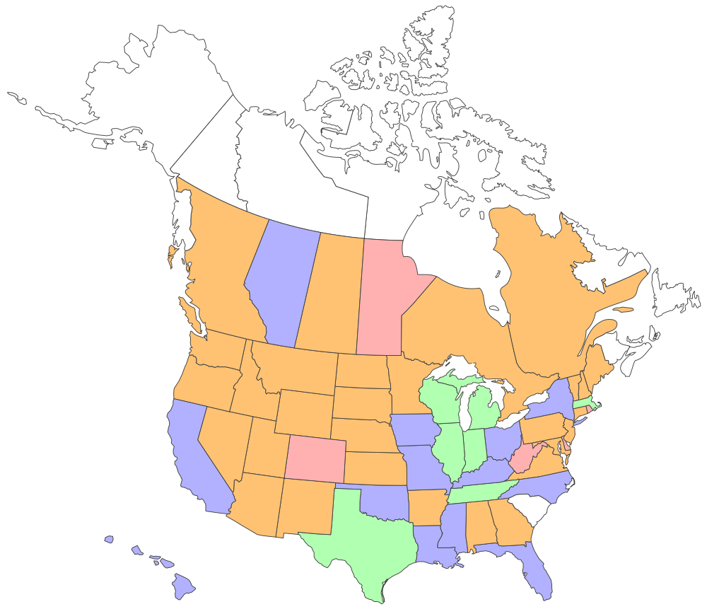
Green: either lived in these places or visited so many times I’ve lost count. Very familiar.

Blue: Numerous visits covering a fair amount of the state or province, or one or two visits of strong intensity and some variety. Fairly familiar. (I changed Iowa to blue.)

Orange: Spent the night at least once, saw a relatively limited number of places. (I added Oregon.)

Pink: Passed through (on the ground) but didn’t spend the night.

White (no color): Never visited.

It’s good to have some ambition in this regard, even though making a list and checking it off is a pointless exercise. What I want to do is get rid of all the white and pink areas, but if not, I won’t fret about it (Nunavut seems particularly unlikely).

Prefecture Osaka

PrefectureOsakaTwenty-five years ago this week, primed by a young man’s sense of adventure, I moved to Japan. Eventually I learned my way around, literally and figuratively, without the assistance of the Internet, since it wasn’t in common use. One of my better investments along those lines — literally getting around, that is — was a paper atlas called Prefecture Osaka.

At least, those were the roman-letter words on the cover. In fact, those were the only roman letters in the entire book. Extracting useful information sometimes took a while but — in that great eventually again — I learned my way around the book, too.

Sometimes I would stare at it, just because I enjoyed looking at it. The lines, the tints, the utterly foreign script — it’s a beautiful group of maps. This is one of the pages. As it happens, the northern part of Sumiyoshi Ward, which is where I lived. My block’s nearly in the fold, so it isn’t displayed here. But a lot of familiar places are.

OsakaMapOldNeighborhoodThe whole-page scan doesn’t really do it justice, though. Even the close-up doesn’t, but imagine a crisp paper version of this image, because digital will never capture the aesthetics of paper.

OsakaMapOldNeighborhood2The bright yellow rectangle is the JR Nagai station (these tracks). The white rectangle is the Nagai subway station on the Midosuji Line. I rarely used JR, but I went to the Nagai subway station just about every day. Urban Japan, as our urban planners say, has high walkability.

The ward was further divided, as marked by different tints on the map. My area was called Nagai-Nishi: West Nagai. That was further subdivided — twice. The smallest divisions are the blocks marked by the small blue numbers. The green space on this map is green space: Nagai Park (Nagai Koen, 長居公園 ). Literally, Long Park.

Arcane Sunday Bits

More snow on Saturday, which probably removes the risk that we might see patches of ground again before sometime in March. More shoveling last night, though this time Lilly helped. That was the price of borrowing the car today.

Tenchi Meisatsu (Samurai Astronomer) was an interesting movie. As I was watching it yesterday, it occurred to me that I knew little about the pre-Meiji Japanese calendar, except that it had been borrowed from the Chinese, and tossed out in favor of the Gregorian calendar. Tenchi Meisatsu (2012) is the story of Yasui Santetsu, the first official astronomer of the Tokugawa shogunate, and his dramatized efforts to reform the Japanese calendar in the 17th century.

As the reviewer at the imbd points out, that’s an unusual subject for a movie, yet it’s effective. As a Japan Times reviewer points out, “it’s probably the best film about calendar making you’ll ever see.” So far, that’s true. I don’t expect to see an action thriller about Pope Gregory any time soon, and poor old Sosigenes didn’t even rate a mention in the HBO series Rome that I recall, though he seems to have been a character in the 1963 movie Cleopatra.

Another arcane matter: It’s never occurred to me to have a favorite map projection, but I know enough to find this funny. I’m fond of most any map, except for grossly inaccurate tourist maps. That is, the sort that have a few vague lines of actual geography, but which mostly sport drawings of famous places or random fun-time activities. They aren’t real maps anyway.

These are some interesting maps. Especially this one.

Tuesday Recommendations

Butter toffee from Guth’s End of the Trail Candy Shoppe in Waupun, Wis., a burg southwest of Fond du Lac. Every year a PR company I’ve long dealt with sends me a box for the holidays. It’s the only time I eat toffee. It’s insanely good. Only a few pieces will make you feel a little queasy, so rich is the confection. But you eat them anyway.

The Man of Bronze. It’s the first Doc Savage novel, and probably the only one I’ll ever read. With genre pulp, that’s usually enough. I have memory fragments of the mid-70s Doc Savage movie I didn’t see – not many people did – so I’m probably remembering the commercials. My friend Kevin recommended Doc Savage as an entertaining read of no consequence, and I’ll go along with that so far. You have to like a yarn that begins with the sentence, “There was death afoot in the darkness.”

Gravity. It’s a really engaging Man Against Nature story, or to be more exact, Woman Against Vacuum. With a one-damn-thing-after-another plot that keeps your attention. Also, worth the extra money to see in 3D, and not too many movies are. In fact, the depiction of space alone is worth the price of admission. A few of the space-science stretchers bothered me a little – I don’t think hopping from spacecraft to spacecraft is quite that straightforward – but not that much. I don’t want exact space science from a movie, just high verisimilitude, and this movie delivers.

Lizard Point Consulting’s geography quizzes. Every now and then, I make Lilly and Ann take some of the easy ones, such as U.S. states or capitals. It’s my opinion that every adult American citizen without cognitive impairment ought to know all of the states.

But I can’t brag about a lot of the other quizzes. It’s clear that my knowledge of, say, French regions is fairly meager, and sad to say I don’t do that well on Japanese prefectures, either – I tend to remember only the ones I’ve been to, plus a scattering of others (like Aomori, where Aomori apples come from, because it’s due south of Hokkaido).

Even quizzes that ought to be easy-ish, such as African nations, have their confusions. Without looking, which one is Swaziland, which one Lesotho? Which is Benin, which one Togo? Which one is Guinea, which one Guinea-Bissau? (That should be easy, Guinea’s bigger.) Similarly, it’s hard to keep track of which –stan is which in Asia, except for Pakistan, Afghanistan, and Kazakstan.

Maps, Maps, Maps

Back again around September 22 — about on the equinox. That’s just a coincidence, since it’s the next Sunday that I want to begin posting again. But those days must mean something. Years ago, I took a flight across the equator on the solstice, and I turned into a Druid for a few minutes.

I have a collection of maps, many of which I’ve picked up as I visited places. Recently I moved them out of the lower level of the house, and as I was leafing through them, it occurred to me that my daughters — if they’re ever so peripatetic — will probably not end up with a clutch of paper maps. They’ll have some electronic box that offers directions wherever they are: New York, London, Paris, Munich.

Paper maps can be cumbersome. Of course I use Google Maps and its ilk sometimes. But my daughters and their cohort don’t know how much they’ll be missing without paper maps.

I’ve posted about that Stadtplan Berlin before, and one of my favorite maps ever (not pictured), Bensons MapGuide London Street Map.

And when am I going to give up my paper maps? When they pry them from my cold, dead fingers.

Mali by Golly

How often is Mali in the news? Here in North America, anyway, since I’d think the French pay more attention to French West Africa than we do.

Not too often. It’s the kind of place, under normal circumstances, gets mentioned in a half a column in a publication like the Economist occasionally because of a change of government, violent or not. Last time it was top of mind for me was when I got a postcard from Timbuktu.

I always thought country had an interesting shape. A compact area along the Niger and below 15 degrees N., plus an enormous lobe reaching out into the Sahara. You can see how a rebellion might get some traction up in the far-flung reaches of that lobe. By vicious Islamist bastards, from the sound of it. (Listen to that lovely first track posted with that article.)

I had to check: Mali’s total area is 478,841 sq. mi., making it the 24th largest country on Earth by that measure. You could put a Texas and a California in there with room to spare, so that’s a sizable chunk of land to quarrel over.