Peace Arch Park

One thing to think about at Peace Arch Historical State Park in extreme northwestern Washington state is the last time the United States invaded Canada, namely the bungled campaigns of 1812 and ’13. Bungled from the U.S. point of view, that is, though of course there were some successes, such the battles of the Thames and Lake Eire (“We have met the enemy and they are ours.”).

The War of 1812 was the last bit of fighting along the U.S.-Canada border, not counting spats over fishing, so it’s reasonable that a bi-national park on the border commemorates the long peace. Peace Arch Park is that place, 22 acres south of the border (Peace Arch Historical State Park) and nine hectares north of the border (Peace Arch Provincial Park).

I arrived around noon on August 25, driving up from Bellingham, Wash. You take the last U.S. exit on I-5 (or maybe it’s the first exit) and park nearby, just south of the border, and then walk to the Peace Arch, which is slap on the border, meaning it’s also exactly 49 degrees North, as well as in the grass median between the northbound and southbound lanes of the highway (the meeting of I-5 and BC 99). Since traffic stops on each side of the border, crossing the road on foot there isn’t very risky.

Peace Arch, August 25, 2015
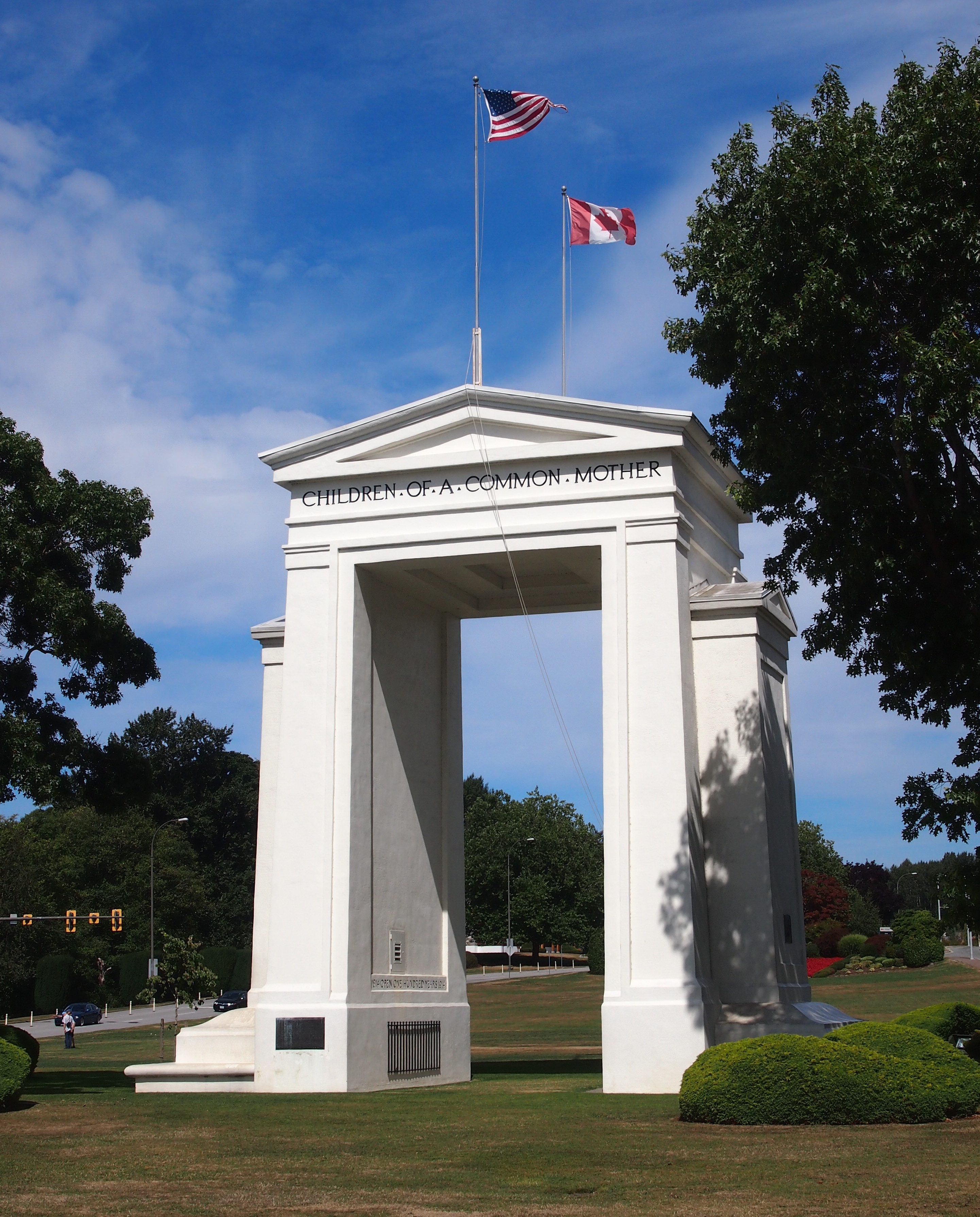
On the U.S. side, the Arch is 67 feet tall; on the Canadian side, 20.5 meters. It’s been standing for there for 94 years, built at the behest of Pacific Northwest business tycoon Sam Hill (1857-1931), who also had a replica of Stonehenge built in another part of Washington state, and who was an avid advocate of road improvement. (“Good roads are more than my hobby; they are my religion.”) Presumably Hill would have been happy that a major road linking the two nations passes around the Arch.

The border’s also marked by a number of concrete posts.
US-Canada border
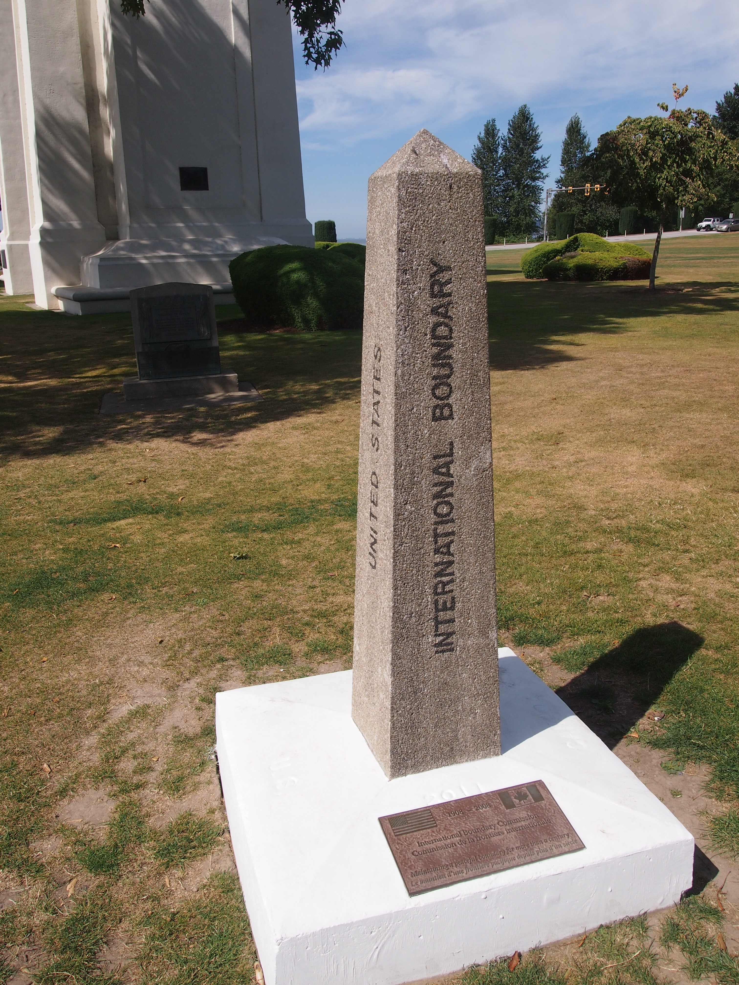
The International Boundary Commission (Commission de la frontiere internationale) put the plaque at the bottom of the post on the occasion of its centennial in 2008. I figure most Americans, and most Canadians, have never heard of the commission. I barely remember reading about it some years ago in the context of the Alaska-Yukon border.

According to the commission’s web site, “Officially, the Commission’s work is described as maintaining the [U.S.-Canada] boundary in an effective state of demarcation. This is done by inspecting it regularly; repairing, relocating or rebuilding damaged monuments or buoys; keeping the vista cleared, and erecting new boundary markers at such locations as new road crossings.”

My italics. This is the body that’s responsible for clear-cutting the border between Alaska and Yukon — a 20-foot (six-meter) swath all the way along the 141st meridian. Since I read about that some years ago, I’ve since pondered the usefulness of doing such a thing. The commission asserts that “the boundary vista must be entirely free of obstruction and plainly marked for the proper enforcement of customs, immigration, fishing and other laws of the two nations.” I’m not quite persuaded, but anyway, more about the line is here.

The border posts have four sides: UNITED STATES on the south face (visible in my picture), CANADA on the north face, and INTERNATIONAL BOUNDARY and TREATY 1925 on the other two. I wondered about that. The commission references it too.

The treaty’s formal name is: “Treaty Between the United States of America and His Britannic Majesty, in Respect of the Dominion of Canada, to Define More Accurately at Certain Points and to Complete the International Boundary Between the United States and Canada and to Maintain the Demarcation of that Boundary, Signed at Washington, February 24, 1925.”

I made a point of crossing and recrossing the border a number of times near the posts. Now I can accurately say I’ve been to Canada more than a dozen times, including the six regular check-your-passport visits, plus the half-dozen (maybe more) crossings at the Peace Arch.

Black Hawk & John Deere 2003

In April 2003, we took a short trip to north-central Illinois. We made a stop at the Black Hawk statue, whose formal name is “The Eternal Indian,” by Lorado Taft in Lowden State Park in Ogle County.

As I wrote then, “the statue, made of concrete, is about 50 feet high and stands on a bluff overlooking the Rock River and some of the town of Oregon. The head and neck represent an Indian, looking pensively off into the distance. His arms are folded in front of his chest, and from there on down the statue is less representational, but is clearly a human form.”

BlackHawkWe also took a look at the John Deere Historic Site in Grand Detour, featuring a blacksmith demonstration.

Deere“The re-created smithy was… the exact size of John Deere’s original Grand Detour shop, not including a latter addition, and presumably the original didn’t devote about a fifth of its space to a railed-in section where tourists stood. Otherwise, it was an evocative re-creation. A lot of iron & steel tools and implements on shelves, hanging on pegs, scattered around on various tables and benches. A bellows and a coal-burning furnace, which was glowing. A real anvil and some mean-looking, anvil-beating tools at hand.”

Two Stops on the Hill Country Bat Trail

Somewhere or other Jay heard about a bat roost near Comfort, Texas, and if that isn’t an incentive to visit that place when you’re already close by, I don’t know what is. So on the afternoon of the 14th, we went looking for it.

Comfort is a small town, pop. 2,300 or so, in Kendall County and, according to the Census Bureau, part of the San Antonio MSA. I’d put it in the Hill Country, though that’s not an official designation. Comfort’s main street (named High Street) is characterized by handsome 19th-century buildings, many made of local stone, put to 21st-century purposes, such as antique stores and restaurants that point out — or should point out — that they offer Comfort food.

To get to Comfort from San Antonio, head northwest on I-10. On Ranch to Market Road 473, a few miles east of town, you’ll find this curious structure.

Bat Roost, near Comfort, TexasAccording to the Texas Historical Commission plaque at the site: “This shingle style structure was built in 1918 to attract and house bats in an effort to eradicate mosquitoes and thereby reduce the spread of malaria. It was designed for Albert Steves, Sr., a former mayor of San Antonio, by Dr. Charles A. R. Campbell, an authority on bats who had served as the health officer in the same city. Named ‘Hygeiostatic’ by Steves, the bat roost is one of 16 constructed in the United States and Italy between 1907 and 1929. Recorded Texas Historic Landmark – 1981.” It’s also on the National Register of Historic Places.

No bats were at home, it being February. I understand that they do live there in the warmer months. Different sources put the number of such towers in this country at two or three. Apparently one of the others is on Lower Sugarloaf Key in the Florida Keys.

North and east of Comfort, not far from Fredericksburg, is Old Tunnel State Park. Formerly a railroad tunnel, it’s now a home for bats. During the warm months, you can sit outside the entrance and watch bats emerge around dusk — a smaller version of the bat flight out of Carlsbad Caverns, memorable enough that I remember it after 40+ years. Again, no bats were around in February. But on hand were a couple of bat enthusiast-volunteers to tell casual visitors about the bat cave, and we talked to them a few minutes.

That’s two stops on the hypothetical Hill Country Bat Trail. Another could be the Congress Street Bridge in Austin, also known for as a bat habitat, or Bracken Cave in Comal County.

James “Pate” Philip and His State Park

The Illinois Department of Natural Resources tells us that “first-time visitors to James ‘Pate’ Philip State Park (formerly Tri-County) may initially wonder what the area’s specific feature is. After all, the land is predominantly farmland that had been tilled and grazed for years. The north branch of Brewster Creek flows through the property, but most of the streambed had been channeled to move water away from former agricultural fields. Along the north boundary of James ‘Pate’ Phillip State Park, starting in the east, a row of houses rises up like a wall against a sea of grasses. Further west along the boundary is an active gravel pit and by the Bartlett Park District sport field. To the west of the park, across Route 25, is a landfill in the process of being closed.”

I wondered something along those lines on Saturday, when we went to take a walk at James “Pate” Philip State Park (Philip is a retired state politico; I’ve never read an explanation for the nickname, but he’s always referred to by it).

I’ve seen the park on maps as a green blotch for some time now. It was created about 10 years ago. I assume it had been farmland until then, though housing development probably came close in the 1990s. Now the idea is to return it to prairie, and dechannelize the creek.

Seems like a good idea to me. The Prairie State doesn’t have quite enough prairie. Since we had cloud cover and only warm temps, it was a good walk. The park is mostly flat and lush in early July, with grasses almost as tall as a grown man and a lot of wildflowers – including clusters of tiny gorgeous orange blossoms that I don’t think I’d ever seen before. My natural history knowledge is meager, so I might not ever know what they’re called.

I was also intrigued by the fact that the park is within three counties: mostly Du Page, but also Cook and Kane. The tri-county border is, in fact, within the park. I don’t know if there’s any kind of marker, and we didn’t feel like walking far enough to see it, but maybe I’ll go look someday.

We also visited Pratt’s Wayne Woods on Saturday, just south of Pate Philip’s State Park, and took a walk around one of its bodies of water. It was to have been part of a state park, but that didn’t happen, and it’s now a part of the Forest Preserve District of Du Page County – at 3,400-plus acres, the largest chunk under its authority, in fact. The district says, “Pratt’s Wayne Woods Forest Preserve in Wayne is located on the outwash plain of the West Chicago Moraine. Made up largely of wetlands, this landscape combines calcium-rich water with wet sandy soil to support plant life more commonly seen near Lake Michigan.

“Today, the forest preserve is home to over 1,000 species of native plants and animals. Below the savanna’s widely spaced oaks grow dogbane, pale-leaved sunflower and smooth yellow violet wildflowers. In the marshy areas, explorers can view great Angelica, marsh marigold, shooting star, nodding ladies’ tresses and spotted joe-pye weed as well as egrets, great blue herons and wood ducks.”

We saw a lot of plants and a few animals, probably including some of those listed above. But the district forgot to mention what a swell habitat the park is for mosquitoes and especially gnats. It’s been a good year for gnats.

Tri-State Leftovers

Cool for July 2, but I know the heat will return. Such are Northern summers. Tomorrow isn’t a holiday, but it ought to be. Back to posting on Sunday.

The bridge that crosses the Mississippi from Savanna, Illinois, to Sabula, Iowa, is exactly wide enough for two vehicles, and no wider. It’s a steel truss bridge, and more than 80 years old. These facts alone make it a thrill to drive across, but a conscientious – make that sane – driver isn’t going to take in the view of the Father of Waters while crossing; he has to leave that to his passengers.

The main steel structure on the Iowa side eventually gives way to a much longer and slightly wider causeway that passes through high waters and lush green islands. At that point it’s Iowa 64, and also US 52. The last time I drove over such watery lushness was in Louisiana bayou country.

North from Sabula to Dubuque is also US 52, and a branch of the Great River Road. At this point, Illinois 84 (and a bit of US 20) is the branch of the Great River Road on the opposite bank, in Illinois. We spent a fair amount of time on both roads the weekend before last, and I can say one thing: bikers are fond of the Great River Road. We saw a lot of them on the roads and parked in various towns along the way. They weren’t usually young men, but mostly wizened fellows, probably out for the weekend.

The Great River Road is actually a chain of state and local roads passing through 10 states from Louisiana to Minnesota, or vice versa if you travel the other way. It’s a National Scenic Byway totaling over 2,000 miles, according to the Federal Highway Administration. Signs along the way look like this (and in fact we drove past this exact place).

We stopped for a moment in Bellevue, Iowa, on US 52 to take a peek at Lock & Dam No. 12. There’s a small roadside park that offers a nice vantage of the structure. Lock & Dam No 12, Mississippi River, June 2014As I got out of the car to look at the dam, I noticed a young family – husband, wife, child of three or four – also standing in the park, seemingly admiring the structure with more intensity than people usually devote to infrastructure. Odd. (My own family members were in the car.) Maybe they were a couple of young engineers. For the record, the dam creates Pool 12, with a total capacity of 92,000 acre ft. The US Army Corps of Engineers completed it in 1939 and still operates it, and the structure’s been on the National Register of Historic Places since 2004.

The campgrounds at Mississippi Palisades State Park are well-designed and expansive. They don’t cost that much, either: $10 per night for a tent site. But the wet spring and early summer, and probably the close proximity to the Mississippi and many smaller pools of water, also meant we were in close proximity to a lot of bugs. This bothered Lilly and Ann in particular – you should have heard the commotion when they discovered a spider hitchhiking a ride in the back of the car. In the vicinity of the campground itself, mosquitoes mostly weren’t the problem, or maybe our DEET kept those away. Gnats were the biggest nuisance.

By night, they’d all calmed down and the fireflies were out. Gnats = nuisance. Fireflies = joy to behold. They don’t get in your face and they put on a show.

Tri-State Summer Solstice Weekend ’14

Late on Friday morning we drove west for a few hours – and enjoyed a remarkably long in-car conversation among ourselves, no radio or other electronics playing – and by mid-afternoon arrived at Mississippi Palisades State Park, which overlooks the Mississippi River just north of Savanna, Ill. The plan included bits of three states in three days. My plan, really, since my family humors me in such matters, and lets me think up the details of little trips like these.

Friday was Illinois. We camped at Mississippi Palisades, which is an Illinois State park and incredibly lush this year, and we spent time in Savanna, a little river town on the Great River Road, mostly to find a late lunch. Toward the end of the day, we made our way to Mount Carroll, Ill., which is the county seat of Carroll County and home to a good many handsome historic structures.

On Saturday, we ventured into Iowa – it really isn’t far – and first saw Crystal Lake Cave, just south of Dubuque. In Dubuque, lunch was our next priority, followed by a visit to the Fenelon Place Elevator. Which is a funicular. When you have a chance to ride a funicular, do it. The last time we were in Dubuque, I remember the Fenelon Place Elevator being closed for the season (uncharacteristically, I don’t remember when that was — the late ’90s?). Anyway, this time I was determined to ride it.

Afterward, we headed west a short distance to the town of Dyersville, Iowa, home to the Basilica of St. Francis Xavier, but better known for The Field of Dreams movie set, which still draws visitors. We saw both.

Today was mostly about getting home at a reasonable hour, but I had to add a slice of Wisconsin by navigating a number of small roads until we came to Dickeyville. It would be just another rural Wisconsin burg but for one thing: the Dickeyville Grotto, which actually includes a main grotto, smaller grottos, shrines, a church and a cemetery (and a gift shop, for that matter). Like funiculars, grottos demand our attention, especially such as striking bit of folk architecture as the Dickeyville Grotto.

NC Early ’81

The demographics of this visual gag is a bell curve based on age. The bulge of peak understanding would be roughly between age 45 and 55. For my part, I laughed right away. It also reminded me of the early ’80s.

My spring break trips during the period weren’t particularly decadent. Downright wholesome, sometimes. I’m glad I wrote this down. I barely remember most of it.

March 4, 1981

Carolina Beach State Park. After dark, we cooked and ate dinner. The campstove was working, compared with the disappointment of the previous night, because we read the directions this time. We were alone in the park, which was a little spooky there under the big pines, but it wasn’t that cold, so on the whole we figured it would be good to sleep outside in our sleeping bags. Unless it rained.

Shortly after crawling into our bags for the night, which were warm and comfortable, we felt a few drops. Then a few more. Then some bigger ones. Then boom! and a flash of lightning. So much for warm and comfortable, or at least dry. We retreated to the car and didn’t come out until morning. Neal had the driver’s side of the front, I had the passenger’s side, with my head up against one of the sleeping bags next to the window, and Stuart had the back seat, which wasn’t much bigger, considering the everything stowed back there.

Naturally, it was hard to sleep. Instead we talked about this and that, including stories about other trips we’d taken, or other times when things hadn’t gone according to plan. I told them about how three years ago exactly, Ellen had shattered Nancy’s glass-top table [or rather, Nancy’s mother’s table] by trying to bound across it during a party we were all attending. Eventually we did sleep, though I can’t call it restful.

The next morning [March 5] the campground was completely soaked. We left in short order. We a found a series of covered tables at Hugh MacRae County Park in Sea Breeze (New Hanover County) and stopped for an hour there to make breakfast. I also put together the kite we’d bought on Bodie Is. The sun was out and temperatures were rising, so we went to Wrightsville Beach for a while.

Neal and Stuart threw a Frisbee around while I flew the kite. It took a while to get it airborne, but the wind was up (and temps in the 60s, so pleasant), and I got it flying very high over the ocean. To keep it stable, though, I kept having to give it more and more line. When I tried to bring the kite in, the thing got unstable and looped until I gave it more line again. Eventually the kite broke in mid-air and I crashed it onto the beach. Should have crashed it into the water, which would have been more dramatic. While it flew I enjoyed its motions against the partly cloudy sky, wind blowing and waves making their back-and-forth sound.

Toward noon, dark clouds returned, and we headed back to Durham mostly on US 421 by way of historic Wilmington and later Spivey’s Corner, which I’d only ever heard of because of Johnny Carson. For lunch we paused at a roadside table in Clinton to eat hot dogs and so forth, and an old farm dog befriended us for our food. We gave him an extra weenie.

Red Bird

And just who was Red Bird? An early 19th-century warrior of the Winnebago, or as they call themselves, the Ho-Chunk. To my ear at least, that double naming works out well, since Winnebago is a fine name for the major lake in Wisconsin, and Ho-Chunk is a fine name for the tribe’s 21st-century casinos, which are in Wisconsin Dells and other places (and which advertise a fair bit in the metro Chicago market).

There’s a large statue of Red Bird facing Lake Winnebago at High Cliff State Park.

Its plaque says the statue was “designed by Adolphe E. Seebach” and “executed by Sculpture House, New York.” Seebach was apparently a Wisconsin sculptor who died in 1969, but a cursory look for him doesn’t uncover much more.

The Banta Company Foundation paid for the work; information on Banta isn’t hard to find. It was a large printing company based in Menasha, one of the Fox Cities, in business for over a century until R.R. Donnelley swallowed it in 2006. Why the company foundation decided to sponsor a statue of Red Bird in 1961—the date on the plaque—I couldn’t say. But there he stands, supposedly depicted as he was in 1827.

The Wisconsin Historical Society says of Red Bird: “Wrongly informed that the U.S. had executed two of their warriors, and thinking other tribes would support them due to widespread white incursions on Indian land, a party of Ho-Chunk from LaCrosse [including Red Bird] attacked settlers near Prairie du Chien in the last week of June, 1827. They killed two men and assaulted a child before returning to their village. On June 30th, a keelboat passing that village was attacked because the Ho-Chunk believed it was the same one whose crew had recently abducted and raped several Indian women.

“In response, the U.S. Army moved troops up from St. Louis, local militia units were hastily formed, and a total of ca. 600 soldiers assembled at Prairie du Chien. Another 100 militia were gathered at Green Bay, where 125 Menominee, Oneida and Stockbridge warriors joined in support of them. In late August these two forces converged from different directions on the assembled Ho-Chunk near Portage. On Sept. 2, 1827, Ho-Chunk tribal leaders surrendered the warrior Red Bird and five others, and further bloodshed was avoided. Red Bird died in prison and the other warriors were tried, sentenced to death, but ultimately pardoned.”

Elsewhere I’ve read that Red Bird dressed in his best finery to surrender – which is how he’s depicted in the statue – and expected to be put to death immediately, as he might have been by another tribe. To his bewilderment, he was chucked in prison, the sort of place in which you might die of dysentery, rather than experience a warrior’s death.

High Cliff Graffiti

On the northeastern shore of Lake Winnebago–the largest inland lake in Wisconsin–is High Cliff State Park, whose name ought to be a clue that it offers vistas of the lake. But it’s more than any old cliff. The Wisconsin DNR says that “the park gets its name from the limestone cliff of the Niagara Escarpment, which parallels the eastern shore of Lake Winnebago.”

It wasn’t the first time on this trip we’d seen the escarpment. County Road B in up the Door Peninsula has views of cliffs. According to Door County Coastal Byway, “Door County’s Green Bay side has the true escarpment, with exposed dolomite rock 200-250 feet high. At the base of these rock faces are remnants of the chunks of stone that fall from the cliffs to form ‘talus.’ ”

I wouldn’t know talus if I stubbed my toe on it, but the cliffs were evident, especially at George K. Pinney County Park, just off County Road B. At High Cliff State Park, the vantage is from on top of the cliffs, though trees block the view in some places. Maybe that’s why a wooden observation tower rises above the trees.

A plaque on the tower says, “THIS TOWER is dedicated to WILLIAM M. WRIGHT, spirited leader and longtime friend of High Cliff State Park. Built in 1984 with private funds from Kimberly-Clark Foundation Inc. and High Cliff State Park Association Inc.”

The plaque doesn’t tell you how many steps it takes to get to the top. An unusually helpful graffito at the bottom tells you that it’s 64 all together.

And it is. Eight flights of eight steps each. As you ascend, the helpful graffiti continues all of the way up.

Until you reach the top. You’re rewarded for climbing 64 steps with a broad view of northern Lake Winnebago, which isn’t so large than you can’t see the opposite shore, where Appleton, Neenah, and the other Fox Cities are located.