Lilly in Ecuador

I don’t have any comments to offer here on the jurisprudence of Justice Scalia, but I do crack a smile at his florid prose, as pointed out again recently by endless commentators (and wags who have fun with him). Such writing comes from having no editor to answer to, and a taste for it. I’ve run across most of his terms before — everyone ought to know “argle-bargle” and “applesauce” (in the way he meant it) for instance — but “jiggery-pokery” was a new one on me.

Or rather, an old-sounding new one. It’s a term of abuse that sounds like it might have come up in a London coffee shop argument about the Bangorian Controversy. I was glad to learn it.

Earlier this month, Lilly went to Ecuador and Panama on a Spanish Club trip. It was a big wheel, little wheel trip — one major destination (Ecuador for a week), one lesser one (Panama for three days).

That’s further than I ever got to go on any school trips, though taking a bus to Stevens Point, Wis., from San Antonio for the Mu Alpha Theta National Convention was its own kind of epic, and Amarillo seemed almost as far (Latin Club trip). It was the luck of the draw for her; some years the club goes to Spain, others Costa Rica. All those sound good to me, but Ecuador especially. South America. I’ve never even been close.

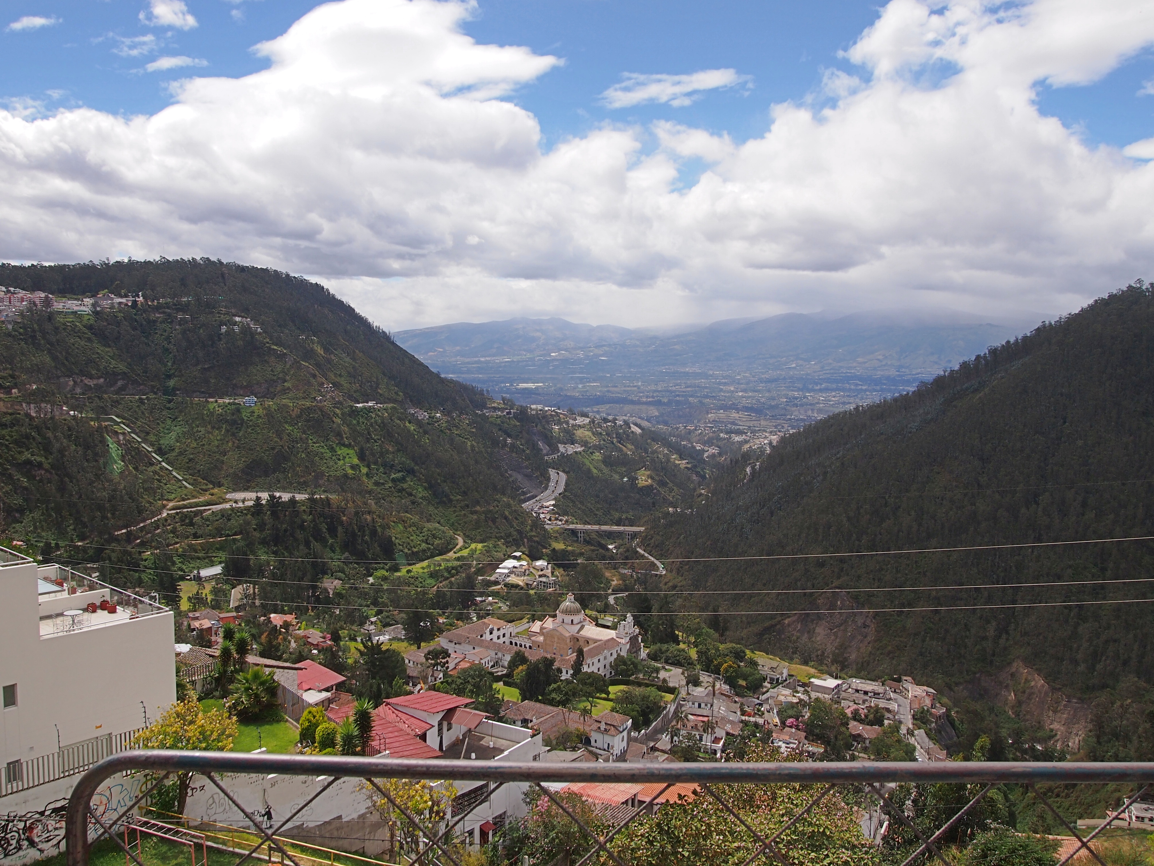
Most of her pictures weren’t selfies. She’s outgrowing a need for excessive self-images, I think. Here’s a view overlooking Quito.

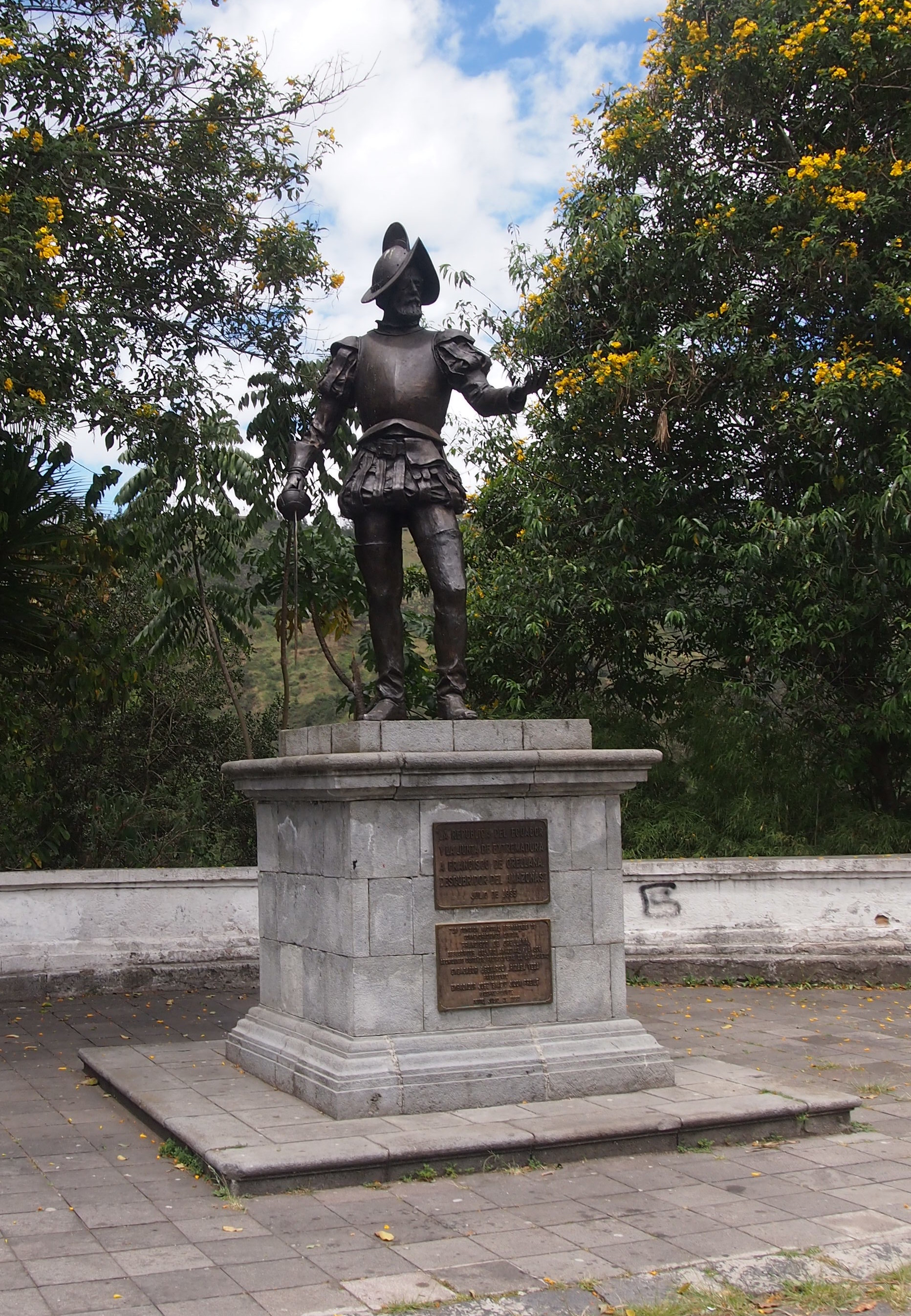
The next pics illustrate her taking after her father, unconsciously I bet, in taking pictures of statues and public art. This particular figure is Francisco de Orellana, explorer of the Amazon. As Wiki puts it, “in one of the most improbably successful voyages in known history, Orellana managed to sail the length of the Amazon, arriving at the river’s mouth on 24 August 1542.”
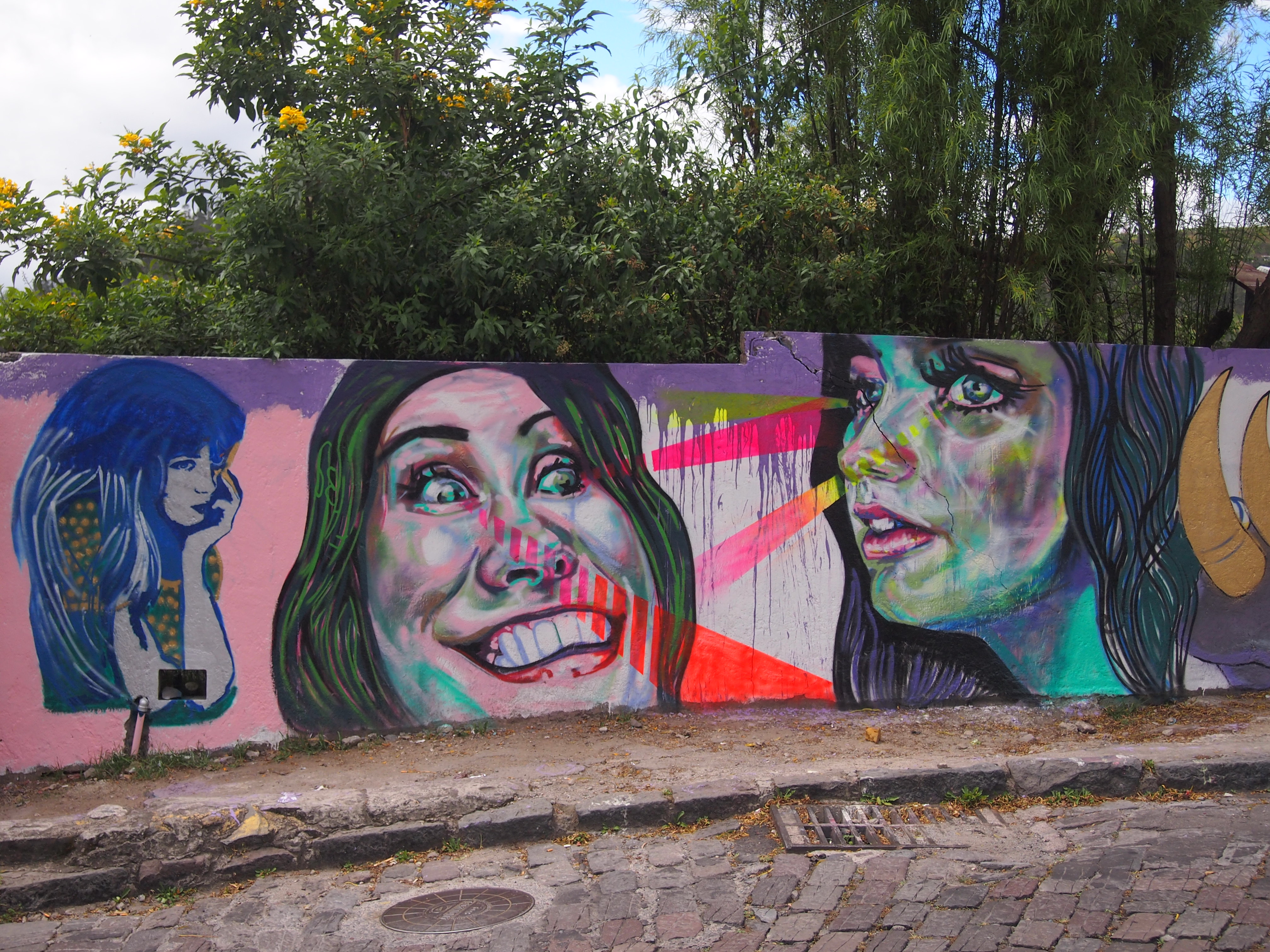
Quito June 2015Some roadside art.
Quito June 2015
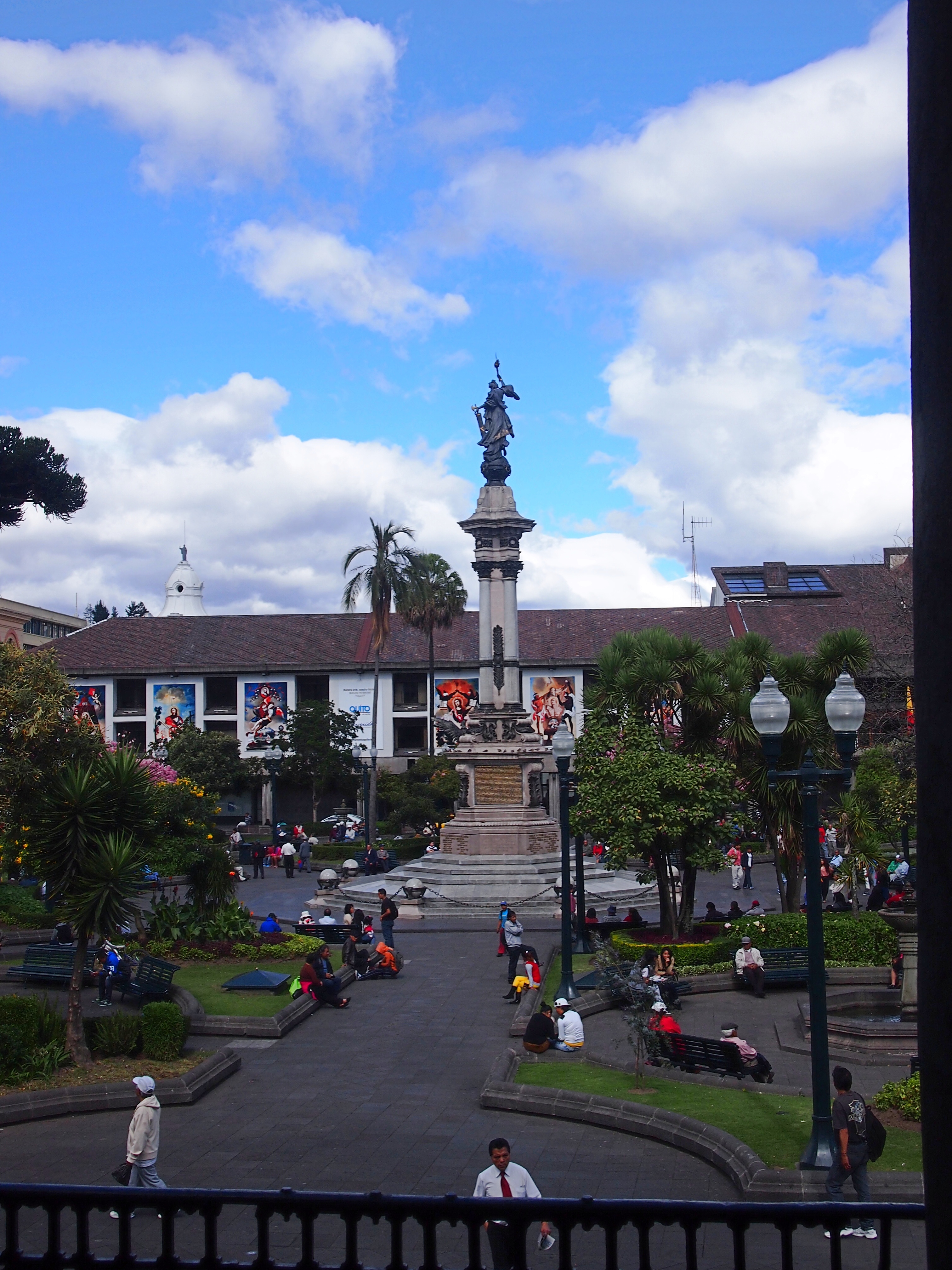
Plaza de la Independencia.

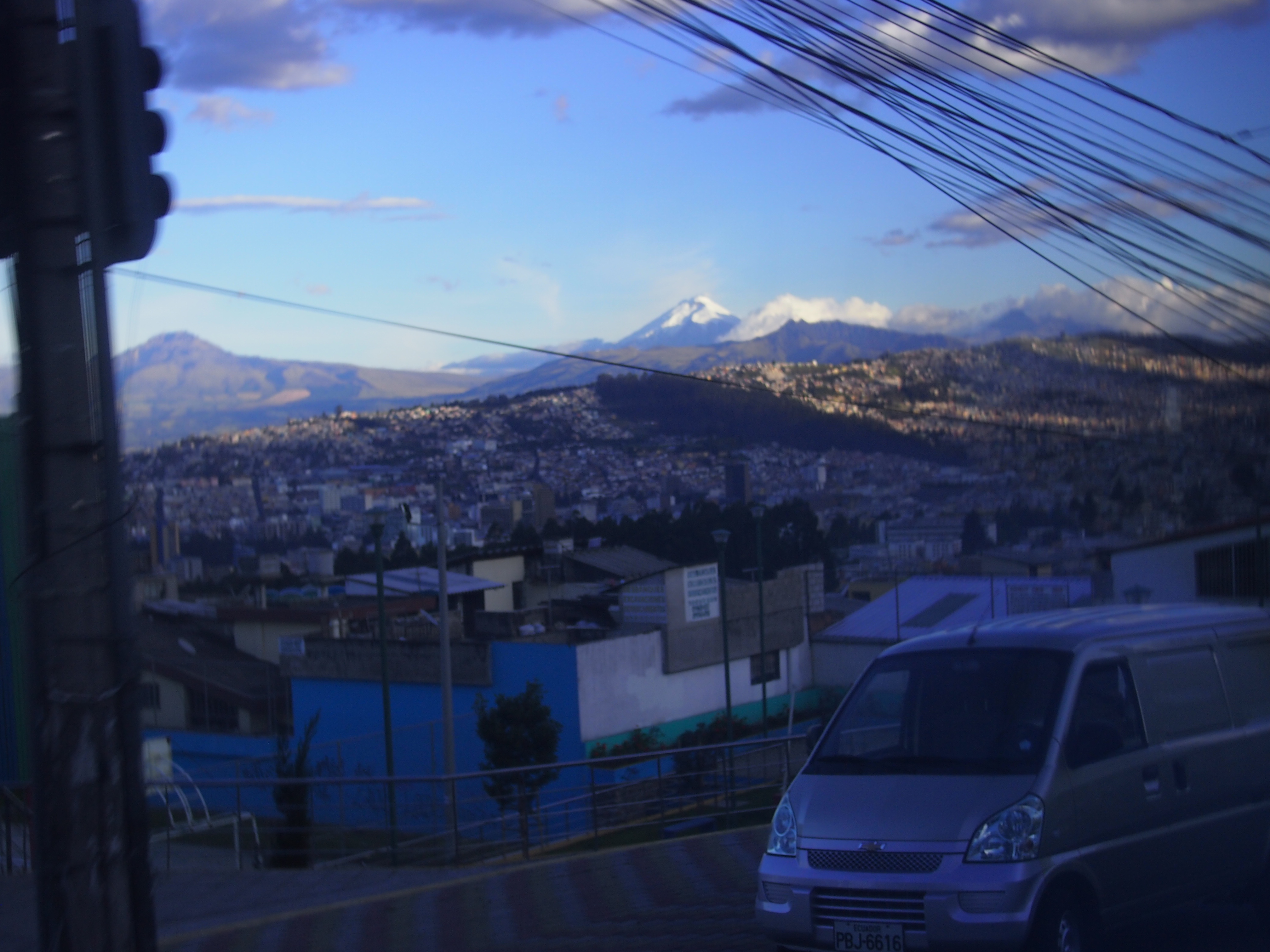
She was also impressed by the fact that she could see a volcano from Quito, which I believe is Pichincha. Alexander von Humboldt was the first European to climb it. I hear tell it’s still active.
Quito 2015Of course there were many more places. She visited the tourist Equator — how could you not? — Plaza Santa Domingo, a couple of art museums, open markets, grocery stores, churches, a school (technically they took a few Spanish lessons), the neighborhood in which she stayed with an Ecuadorean family, even the outside of the Ecuadorean presidential palace. All in all, it sounded like a fine trip. I’d need no persuasion to go myself.

Sprite & Jackfruit in Thailand

The rooms were small at our guesthouse near Kanchanaburi, Thailand, in June 1994, but the price was good: 100 baht, or about $4 a night for the two of us. The rooms were for sleeping. Otherwise, when you were at the guesthouse, you hung out at the patio overlooking the river. Here I am there, staying hydrated.

ThailandJune94.1I don’t remember exactly, but I think I was reading a loose Australian magazine someone had left behind on the patio.

Later in the month, we made our way to Chang Mai, in the north of the country. One of the things to do there is visit Wat Phra That Doi Suthep, which involves climbing 309 steps to the temple grounds. Somewhere along the way, we spotted jackfruit.

ThailandJune94.2Over the years, I’ve found that almost no one in North America’s ever heard of it. (But it’s not as if I ask someone every day.) I’d never heard of it before visiting Southeast Asia either. It’s a tasty fruit, one of the tropical fruits you grow fond of in the tropics. It also disproves the notion that you shouldn’t eat anything bigger than your head. More about it here.

Too bad my face is overexposed. Even so, Lilly saw the picture after I’d scanned it and remarked on my youthful visage, though that wasn’t the word she used. As in, I can’t believe you were ever that young. It’s a hard thing to imagine one’s parents, even if I wasn’t that young at 33.

Palatine Prairie Nature Preserve

I’ve driven by the edge of the Palatine Prairie Nature Preserve and the adjoining Riemer Reservoir Park many times, traveling on N. Quentin Rd. in Palatine, Ill. Last Thursday, I decided it was time to stop and take a look at the place on foot. It happened not be raining, but the evidence of frequent rain was all around in the lush greens of this particular patch of Illinois greenspace.
Palatine Prairie, June 2015That makes it look like the middle of nowhere. It’s no such thing. At the northern edge of the Palatine Prairie is the Union Pacific Northwest line of the Metra commuter rail system (not the line I usually take). Here’s a train bound for Crystal Lake at least, and maybe further northwest, and making the prairie a little less quiet.

Palatine Prairie, June 2015Not that the place is quiet. The roads aren’t far away. Palatine Prairie is the northern section of the greenspace; the somewhat larger Riemer Reservoir is to the south, and they’re separated by the small W. Wood St. A trail winds through both, and it’s a pleasant walk when it isn’t raining or too hot. The weather was just right for us last week.

The greenspace that isn’t completely given over to prairie also includes a disc golf course. Guys were out playing disc golf. They seemed pretty serious about it, too.
Palatine Prairie, June 2015I’ve never played the game myself, though in the connected basements of Branscomb Quad at VU, we tossed frisbees at some kind of goals. Maybe the corridor doors, but I don’t think the rules were very well refined.

The 300 S. Wacker Map

Last week in downtown Chicago, I also got a look at the 300 S. Wacker map, which was unveiled late last year and is easily visible from the west side of the Chicago River near Union Station. That’s because it’s a map as tall as a skyscraper, and who couldn’t like that?
300 S. Wacker 2015A close up.
300 S. Wacker 2015The giant map depicts the Chicago River and nearby streets, from Cermak to Chicago and LaSalle to Jefferson. The 300 S. Wacker building itself appears on the map as a three-dimensional red block.

Previously, 300 S. Wacker had little to distinguish it as a building, and little to catch the eye. Beacon Capital bought it last year and commissioned Elmhurst, Ill.-based South Water Signs to do the work. I’ve read that there are more art maps in the building’s lobby, backlit by LED lights; I’ll have to take a look sometime.

Two Chicago River Bridgehouses

More rain over the weekend and again today. Are we turning into Seattle? Except that Seattle really isn’t the rainiest place in the nation, according to various sources. It turns out most cities in the Southeast U.S. get more rain every year.

But who would understand you if you said, it sure has been rainy lately. Are we turning into Mobile? Information age, my foot. Even easily available data has a hard time killing received notions.

That reminds me of something else I encountered in the Pacific Northwest all those years ago: Slug Death. Or, to be more exactly, Corry’s Slug & Snail Death in the bright yellow box. (It seems to be Corry’s Slug & Snail Killer these days, as if that matters to dying gastropods.) I think we were visiting people on Bainbridge Is., and that’s what they had in their garden. I’d never heard of such a thing. It was one of those ordinary details of a new place that stick with you.

En route to Union Station to catch my train to the suburbs last week, I spent a few minutes looking at some of the bridgehouses on the South Branch of the Chicago River. There’s a museum in one of the bridgehouses of the Michigan Ave. bridge that opened only last month — the McCormick Bridgehouse & Chicago River Museum — but I didn’t have time for that.

Here’s the Monroe St. bridgehouse on the east side of the structure. The bridge dates from 1919 and was built by the Ketler Elliott Co., a name I’ve encountered before.
Monroe St. bridge 2015Looks like it’s been cleaned lately, maybe even since the bridge’s 2000s rehabilitation. The site HistoricBridges.org tells me that “the bridge’s operating and control panels inside the bridgetender buildings were reportedly the first in the United States to have completely enclosed circuitry so that no exposed copper connections were available for bridgetenders to mistakenly electrocute themselves on.”

This is the bridgehouse on the west side of the Adams St. bridge, which was built a little later, 1927, but still during a time when aesthetics was a consideration in a public building project (it might be again, but for quite a spell in the last century, the idea seems to have been on hold).
Adams St. bridge house, 2015The bridge was rehabbed in the mid-1990s. The bridgehouse is dingy, so I guess that’s 20 years of urban air at work. More about the Adams St. bridge is here.

Pre-Victory Parade Chicago

Business took me downtown today. The Blackhawks victory parade is tomorrow, I hear, and I’m glad I’m going to miss that mess. Braving a crowd like that might be worth it to see the first astronauts to return from Mars, but other than that, no.

According to a parking lot sign on W. Madison St., today was very hot.

Chicago, June 17, 2015Or maybe that’s reporting a cold snap on Venus, as long as we’re talking about other planets.

No parade today, but Metra — the commuter rail I took into town — is getting ready.

Chicago, June 17, 2015A wise precaution, even if it’s going to be ignored by some riders. Or technically honored by riders who’re loaded when they get on board. I always disliked riding trains the night of a Cubs or Sox game; the later the train, the louder the drunks.

Also, just outside Union Station, I spied one of those post-championship souvenir vendors that pop up like toadstools after a rain. They were doing a brisk business in t-shirts, hats and maybe other gewgaws and gimcracks. It was too crowded to get a close look.

Chicago, June 17, 2015I didn’t see any Hawks banners hanging from lampposts — maybe I wasn’t looking on the right streets — but I did see other team totems. It seemed like more people than usual were wearing team shirts, for one thing, and then there was this:

Chicago, June 17, 2015The good tourist ship Lila plying the Chicago River, flying a Hawks flag.

Pacific Northwest ’85 Ephemera

Thirty years ago this month, I took a trip to Seattle and other parts of the Pacific Northwest. I hadn’t been there before and I haven’t been back, though I want to go. That was where I saw an enormous fallen tree in Mount Rainier NP and the excellent-in-every-way Butchart Gardens in Victoria, BC.

WAferries85I took no camera. It was that kind of trip. I did return with a lot of ephemera, though. Such as a Washington State Ferries schedule. I was staying with a college friend of mine the first weekend I was there, and took the ferry with him and friends of his. From Seattle to Winslow, I think, but in any case across Puget Sound.

We were the last car in, shoehorned into the back of the ferry, and during the crossing mostly sat in the car listening to a tape of United States Live by Laurie Anderson, which was fairly new at the time. I distinctly remember her relating a story about an obscure Chinese dialect in which the word for “Heaven” and “Moon” are the same, and how it was reported in this part of China that American astronauts had traveled to Heaven. If I were feeling that kind of ambition, I’d listen to the five disks of United States Live to find out where this bit occurs. I don’t feel like it — I’d rather retain this odd amalgam of a memory, made up of her strange story and the trip across Puget Sound, unimpaired by hearing the story again.

That weekend we also spent some time under gray skies on one of the beaches on the sound, playing volleyball and hunting geoduck. Or at least one or two members of the party were looking for geoduck, which I’d never heard of before. From a hole in the sand, they managed to pull up the neck of one of those clams, which was long and gross, but not the body. “That’s one hurting geoduck,” said one of the fellows who pulled it up.

It’s pronounced “gooey duck,” incidentally, and later at the Seattle Aquarium, I saw an entire geoduck. They might be good eating (I didn’t eat one), but they’re also remarkably ugly.

It was also on that beach that I found a shell partly covered in barnacles. It’s a little hard to get an image of it, but here it is anyway, top and bottom.

shell1shell2I’ve had the shell ever since, though some years ago a child managed to break it. I glued it back together. There’s something about it.

BCferries85There was nothing much as memorable about crossing from Tsawwassen to Swartz Bay in British Columbia. That time I was in my own rental car, and drove to Victoria, a fine little city.

On this trip I covered a lot of ground in my car, admiring the forests, except where they’d been clear-cut, and fond of the fields of blooming Scotch broom, which I later learned is an invasive species in the Pacific Northwest. Maybe not quite in a league with kudzu, but bad enough.

One more item, which I kept because you don’t see this kind of thing inland so much: a tide table. It was a lagniappe from the handsome Kalaloch Lodge, which is on the Pacific coast, and actually within the boundaries of Olympic National Park. Kalaloch85I spent the night there. Lovely place, though most of the scenery was obscured by drizzly clouds. Still glad I went. If only to go to a place that gives out tide tables to its guests.

Parade on the 606

On our way back to Humboldt Ave., where we got on the spanking-new 606 linear park on the Northwest Side of Chicago, and where we planned to get off, we encountered a little parade. Looked like an impromptu to-do.

Parade on the 606, 06-06 Parade on the 606, 06-06Whatever uniforms and instruments you got, bring ’em!

Parade on the 606, 06-06Cheerleaders are OK, but flag girls are where it’s at. That’s how I felt in high school, anyway, and some opinions never quite go away. Incidentally, the flag the woman in red is carrying said “FLAG” (as seen in the previous picture). Her shirt said “I ♥ a Scientist.” And note the Chicago flag wristband; nice touch.

And speaking of flags, this is a variation of the Chicago flag I hadn’t seen before.

Chicago flag variationJust happy chance that we got to see the little parade go by. That, and we showed up at the 606 on opening day.

Eastbound on the 606

The 606 is east-west trail with a few kinks and smooth curves here and there, but mostly conforming to the direction of Bloomingdale Ave. below, which itself is part of the Chicago grid. So when we arrived at the Humboldt Blvd. entrance on Saturday, we had the choice of east or west. Humboldt Blvd. is roughly two-thirds of the way toward the west terminus. We decided to go east. Lots of other people were doing the same.

606As you can see, the landscaping still isn’t up to bourgeois standards, but I figure as the years go by, planting will be done, and the trailside will be greener in future Junes. In some places, small trees will become larger trees. Various sources tell me there are 200 species of plant along the trail.

Where the trail passes over Washtenaw St., there’s an “environmental sentinel.”

The 606It’s also apparently the mid-point of the trail, 1.35 miles in either direction. Nice to know. Also nice that the planners resisted Lincoln Chafee’s call for metrification of the trail. (Well, I made that up.) But why “2015 2115”? Is there a time capsule we don’t know about planted here, waiting for the 22nd century?

Volunteers in yellow shirts stood near the entrance ramps, ready to give out information. I got a map from one of them.

606 on 6-06The trail passes under the El — the line that goes to O’Hare from downtown — near Milwaukee Ave.

OLYMPUS DIGITAL CAMERAMighty steel holds up the El. Just what you want if you’re on a train flying overhead. Or underneath the train, for that matter.
Blue LineJust east of that point is the trail’s bridge over Milwaukee Ave., which a major northwesterly spoke road, as opposed to the grid roads. Spoke roads in Chicago were often Indian traces in earlier times.

Milwaukee Ave Bridge“At Milwaukee Avenue, where an arched bridge has served as the public centerpiece to the park during its construction, that story is told horizontally instead of vertically,” Chicago magazine says. “Dolomitic limestone boulders — from the formation that underlies Chicago, the limestone that architects Walter Netsch and Bruce Graham used as an anchor for their Inland Steel Building in one of the city’s herculean efforts to rise above the swamp — lead up towards the trail.”

The majority of the $95 million cost to build the 606 came from a $50 million Federal Congestion Air Mitigation Quality grant. Another $20 million was raised through private fundraising and $5 million came from local government, with ongoing fundraising for further improvements.

I’ve seen people grousing about the cost, especially the fact that the federal government paid so much of it (and I get what I deserve for reading comments sections). Sure, it’s an outrage that the government devoted roughly (very roughly) 0.00016 percent of its annual budget on an investment that’s going to generate large amounts of new value, in a measurable way for private property owners in the area, and in a less tangible but still important way for anyone who uses the trail. You know, spending for the common good.

New residential properties have already been developed in anticipation of the trail, and more are coming. Some examples are in the background here, east of Milwaukee Ave.

606 pix OLYMPUS DIGITAL CAMERAIf the High Line’s any indication, existing retailers will also benefit, and there will be new ones sprouting near the trail.

We made it as far east as Damen Ave., within sight of the dome of St. Mary of the Angels, which I want to see the inside of sometime, then we went back the way we came. So we walked about half of the trail. That leaves the rest for another time.

The 606 on 6-06

What a weekend in the wider world: the first Triple Crown winner since the Carter Administration, a daring prison break by dangerous inmates, and a solar sail unfurls in space. I didn’t know Bill Nye was CEO of the Planetary Society, but I suppose it helps fundraising to have a Science Guy at the top spot.

Here in metro Chicago on June 6, 2015, the 606 opened to the public, and we were there. Usually I don’t bother with opening nights or premieres or the like, but somehow I wanted to be on the 606 on the very first day. Call me a sucker for quality-of-life urban infrastructure.

606The 606, also known at the Bloomingdale Trail, is a new linear park fashioned from 2.7 miles of an abandoned elevated rail line on the near Northwest Side of Chicago, linking the easterly neighborhoods of Wicker Park and Bucktown with Humboldt Park and Logan Square to the west. The line handled freight for decades, serving the factories that used to be in these parts of town. Even before most of the factories closed, trucks had usurped the role the freight line used to play.

As Edward Keegan writes in Crain’s Chicago Business, “Completed in 1913, the 606’s underlying structure elevated the Chicago, Milwaukee and St. Paul Railway freight trains above Bloomingdale Avenue to prevent the frightfully frequent pedestrian deaths of the time. Railroad use dwindled through the 1980s and 1990s, and these four neighborhoods were left with a daunting bit of early-20th-century infrastructure that defied easy demolition. Massive, parallel concrete walls, 7 to 10 feet thick at their base — held earth between them to lift double railroad tracks a full story above surrounding streets. It was a great engineering feat, but the east-west wall separated neighborhoods.”

The thing to do in the early 21st century, then, was to give it the High Line treatment, that is, redevelop it into a linear park, though the end result isn’t exactly the same. “The overall design is remarkably matter of fact,” Keegan notes, and I agree. “A concrete path — 10 feet wide with 2-foot-wide, soft-edged borders on each side for runners — winds the 2.7-mile length of the park. While the bounding walls of the old superstructure are mostly parallel, the designers deftly move the path from side to side and up and down to the extent possible to provide as interesting a path as possible for its users.

“Brooklyn-based landscape architect Michael van Valkenburgh chose more than 200 species of plantings that appear within the park. Due to its east-west configuration and length, Chicago’s lake effect will be evident each spring as certain species, including serviceberries [what?], will take as much as five days to bloom progressively from west to east. But don’t head out to the 606… and expect too much from the landscaping. Plantings are generally quite young, spare and even scraggly in places.”

Some of the benches weren’t finished either. In short, there’s still work to be done on the trail, but even so the warm, sunny day on Saturday make for a good walk, despite the intense crowd of other walkers and bicyclists. The crowd seemed to be in a good mood, which always helps.

In the early afternoon, we drove into town and parked near Humboldt Blvd., which passes under the 606. At the time there was a street festival on Humboldt Blvd. on either side of the 606 featuring music, food, booths of various sorts, and free 606 souvenir buttons.

Ann & Lilly on the 606, June 6, 2015Soon we made our way to the long ramp just east of the boulevard and walked up it to the trail. Then we headed east, occasionally posing for pictures along the way.