The Kansas Cosmosphere and Space Center

Why Kansas? Even the Kansas Cosmosphere and Space Center web site asks that question in its FAQ page. Why is a first-rate spacecraft museum – absolutely the best I’ve ever seen, except for the Smithsonian Air & Space Museum – in Hutchinson, Kansas, a town of about 42,000 northwest of Wichita? The answer: that’s the way the cookie crumbled. Right place, right time.

“The Cosmosphere began in 1962 as nothing more than a tiny planetarium on the Kansas State Fairgrounds,” the page says. When the planetarium outgrew its original facility and moved to its current location, Patricia Brooks Carey and the Hutchinson Planetarium’s board of directors sought business advice from Max Ary, then director of Ft. Worth’s Noble Planetarium. “Interestingly, Ary was also part of a Smithsonian Institution committee in charge of relocating thousands of space hardware artifacts to museums throughout the U.S. The Cosmosphere was granted many of the artifacts.”

These days the museum measures over 105,000 square feet and includes a large exhibit space for rockets and spacecraft, plus a planetarium, dome theater, and more. We arrived in the mid-afternoon of July 13, too late to catch a planetarium show, but in plenty of time to look at a lot of space stuff, expertly and chronically organized for display.

“Most everything you see in the museum was either flown in space, built as a back up for what was flown in space, built as a testing unit for what was flown in space, or was the real deal, but was never meant for space,” the museum continues. “Only a few artifacts are replicas, and those that are replicas, are for good reason. For example, the lunar module and lunar rover in the Apollo Gallery are replicas (though built by the same company that produced the flown modules), because those that went in space, stayed in space. No museum in the world carries a flown lunar module or rover. In fact, they’re all still on the Moon.”

The displays begin at the beginning of modern rocketry – Konstantin Tsiolkovsky and Robert Goddard and on to Nazi rockets, including a restored V-1 and V-2.

V-2 rocket
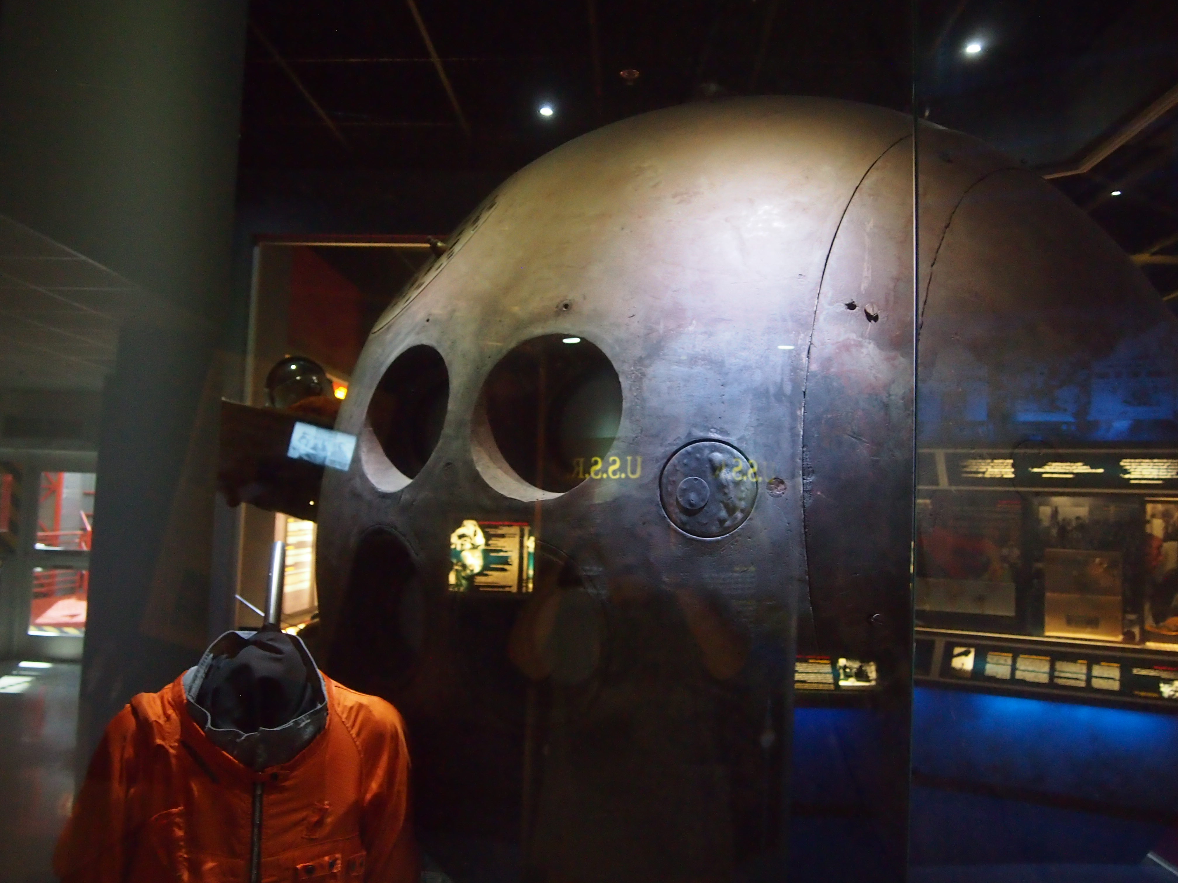
Then on to Soviet and U.S. rockets and capsules that ventured into space, plus a lot of ancillary items. It’s an astonishing collection, including a replica of the X-1, a flight-ready backup for Sputnik 1, a backup version of the Vanguard 1, a Russian Vostok capsule – the only one outside Russia – Liberty Bell 7 (pulled from the ocean floor and restored), a Redstone rocket and a Titan, too, the Gemini 10 capsule, a Voskhod capsule, the Apollo 13 Command Module, a Soyuz capsule, various Soviet and American rocket engines, an Apollo 11 Moon rock, and a lot of smaller artifacts.

I took a particular interest in the Russian equipment because I’ve seen so little of it. In fact, I’d never seen a Vostok, and there it was. Looking like a large bowling ball behind glass. “Hop in, Comrade, and we’ll shoot you into space.”

Vostok
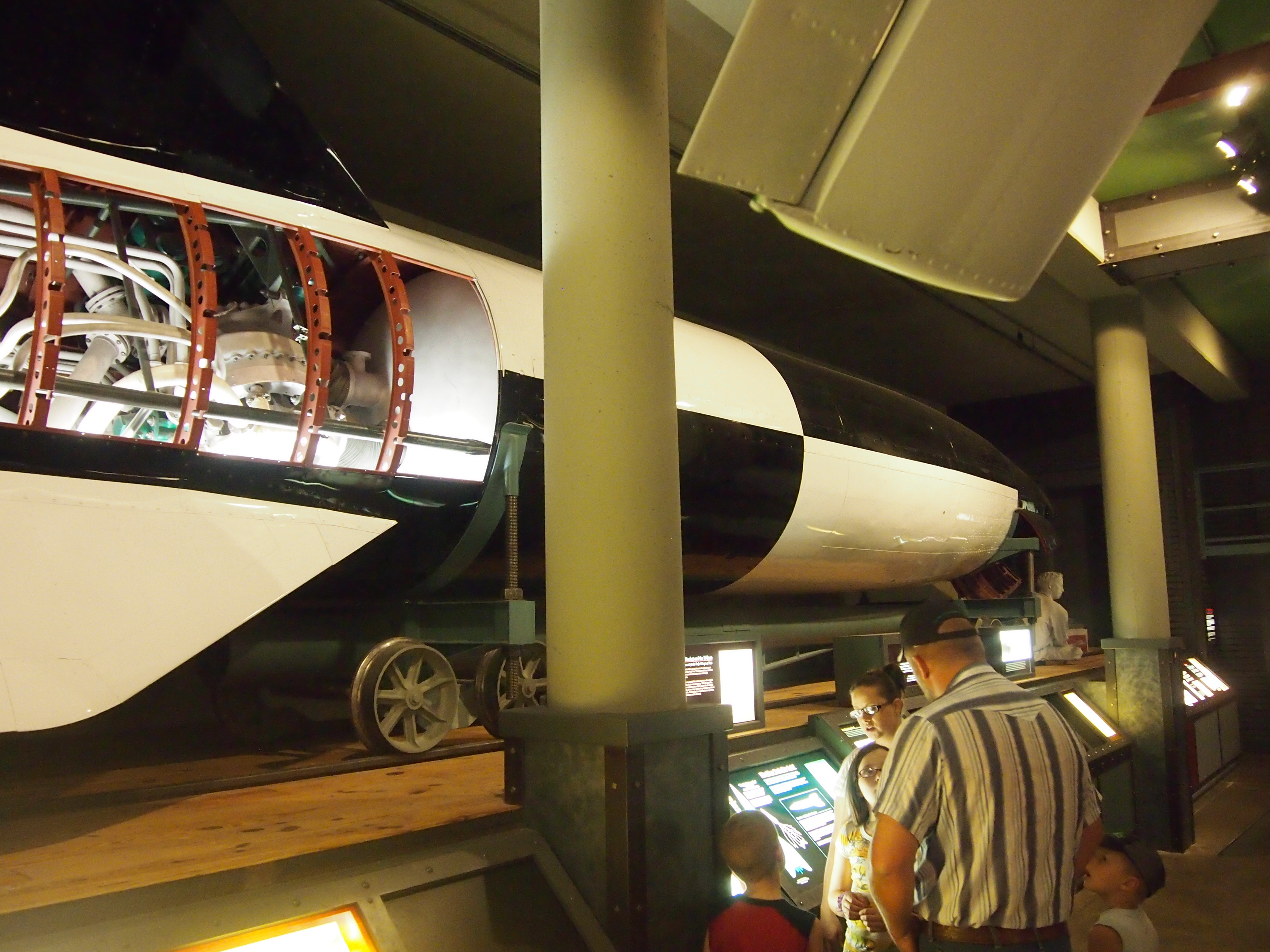
The American equipment was impressive, too, though more familiar. It’s always an impressive thing to stand under a rocket like a Titan, which used to deliver Gemini into orbit. Titan

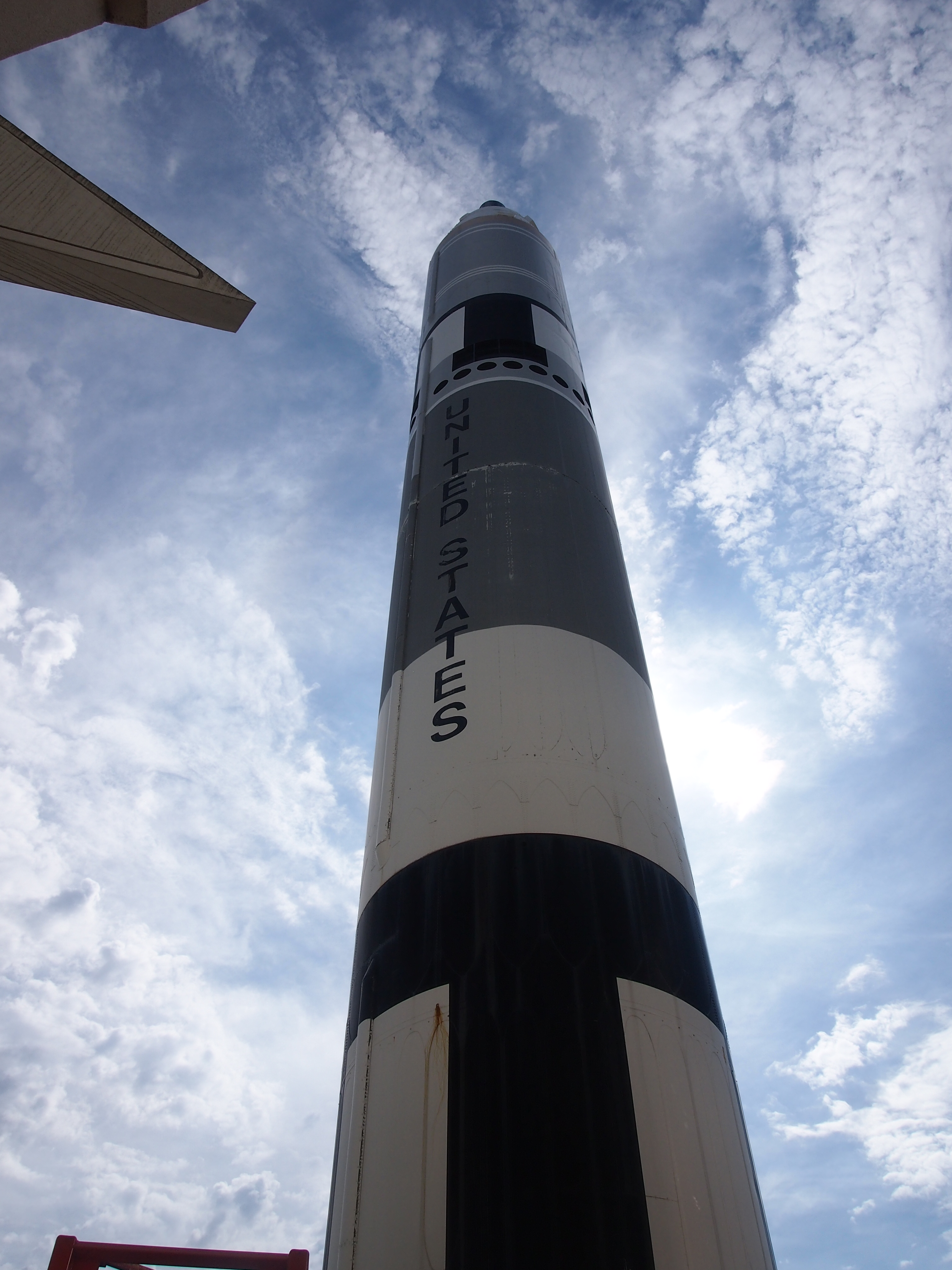
Ann seemed to enjoy herself, and probably learned something. But to really appreciate this museum, it helps to have been an eight-year-old boy in 1969. You find yourself turning the corner and saying, “Wow, look at that!” a lot.

Fifteen Days, Seven States, Nearly 3,000 Miles, and the Blue Hole

Our drive to San Antonio and back started on the morning of July 12 and ended a few hours ago. I actually remembered to set to trip meter as we were leaving, so I know that between backing out of the driveway and returning to it, the car had been driven 2,952 miles and change. Except for when my brother Jay used the car in San Antonio, I drove all those miles. Ann was in the back seat almost all of the time.

Our route southward wasn’t as direct as it could have been, passing from metro Chicago to Des Moines to St. Joseph, Mo., the first day; to Hutchinson, Kan., by way of Topeka the second; and Dallas by way of Wichita and Oklahoma City on the third. After some days in Dallas, travel resumed: to San Antonio via the most direct route, which turned out to be a mistake (more about which later).

Our return northward was more straightforward: San Antonio to Dallas to Lebanon, Mo., and then home, three days’ driving spread out over four days, with a jag into extreme northwestern Arkansas. More about that later as well.

We were caught in two storms so intense that we waited them out beside the road. I saw two suitcases broken open, and their contents spread on the road, on two different Interstates. I’m pretty sure I saw a guy pulled over on the shoulder of yet another Interstate, changing his pants outside his car. We listened to a lot of radio. As hard as corporate interests try, terrestrial radio isn’t quite homogenized.

When I wasn’t driving, I was working (that’s the self-employed life). Or visiting with family members and friends: my mother, two brothers, two nephews and one’s wife, my aunt, first cousin and his family, two friends from high school. Or eating. Some chains, of course, but I did my best to support independent eateries in places like Wichita, Dallas, Austin, San Antonio, and Mt. Olive, Ill.

Besides all that, we squeezed in visits to three museums, the outside of two capitols (closed, unfortunately), a mall, an enormous bookstore, a couple of wooden bridges, and a cemetery with an historic figure buried in it. I also watched a number of early episodes of Treme, an addictively good show.

And I saw the Blue Hole.

Blue Hole, SA, July 2014

I lived within 10 minutes’ drive of the Blue Hole for more than a decade, and every time I visited San Antonio after that for 35 years, I was equally close. Yet I never saw it before this visit. All I can say is, it was about time.

James “Pate” Philip and His State Park

The Illinois Department of Natural Resources tells us that “first-time visitors to James ‘Pate’ Philip State Park (formerly Tri-County) may initially wonder what the area’s specific feature is. After all, the land is predominantly farmland that had been tilled and grazed for years. The north branch of Brewster Creek flows through the property, but most of the streambed had been channeled to move water away from former agricultural fields. Along the north boundary of James ‘Pate’ Phillip State Park, starting in the east, a row of houses rises up like a wall against a sea of grasses. Further west along the boundary is an active gravel pit and by the Bartlett Park District sport field. To the west of the park, across Route 25, is a landfill in the process of being closed.”

I wondered something along those lines on Saturday, when we went to take a walk at James “Pate” Philip State Park (Philip is a retired state politico; I’ve never read an explanation for the nickname, but he’s always referred to by it).

I’ve seen the park on maps as a green blotch for some time now. It was created about 10 years ago. I assume it had been farmland until then, though housing development probably came close in the 1990s. Now the idea is to return it to prairie, and dechannelize the creek.

Seems like a good idea to me. The Prairie State doesn’t have quite enough prairie. Since we had cloud cover and only warm temps, it was a good walk. The park is mostly flat and lush in early July, with grasses almost as tall as a grown man and a lot of wildflowers – including clusters of tiny gorgeous orange blossoms that I don’t think I’d ever seen before. My natural history knowledge is meager, so I might not ever know what they’re called.

I was also intrigued by the fact that the park is within three counties: mostly Du Page, but also Cook and Kane. The tri-county border is, in fact, within the park. I don’t know if there’s any kind of marker, and we didn’t feel like walking far enough to see it, but maybe I’ll go look someday.

We also visited Pratt’s Wayne Woods on Saturday, just south of Pate Philip’s State Park, and took a walk around one of its bodies of water. It was to have been part of a state park, but that didn’t happen, and it’s now a part of the Forest Preserve District of Du Page County – at 3,400-plus acres, the largest chunk under its authority, in fact. The district says, “Pratt’s Wayne Woods Forest Preserve in Wayne is located on the outwash plain of the West Chicago Moraine. Made up largely of wetlands, this landscape combines calcium-rich water with wet sandy soil to support plant life more commonly seen near Lake Michigan.

“Today, the forest preserve is home to over 1,000 species of native plants and animals. Below the savanna’s widely spaced oaks grow dogbane, pale-leaved sunflower and smooth yellow violet wildflowers. In the marshy areas, explorers can view great Angelica, marsh marigold, shooting star, nodding ladies’ tresses and spotted joe-pye weed as well as egrets, great blue herons and wood ducks.”

We saw a lot of plants and a few animals, probably including some of those listed above. But the district forgot to mention what a swell habitat the park is for mosquitoes and especially gnats. It’s been a good year for gnats.

Cape Ashizuri, 1993

Wiki’s helpful when it comes to putting Shikoku in a little geographic context. Hope it’s accurate: “The 50th largest island by area in the world, Shikoku is smaller than Sardinia and Bananal (a river island in the Araguaia River in Brazil), but larger than Halmahera (near New Guinea) and Seram (likewise). By population, it ranks 23rd, having fewer inhabitants than Sicily or Singapore, but more than Puerto Rico or Negros.”

July 2, 1993

Yuriko and I took a train south from Kochi to Nakamura, and then a bus to Cape Ashizuri, the extreme southern tip of Shikoku. The coast reminded me of the coast of Washington state near Kolaloch: rough, rocky, rainy.

Ashizuri1993-1Despite intermittent rain, we took a walk on a path hugging the shore. It was a concrete path, which often evolved into staircases. We went down to the rocky beach and looked at the larger rock formations under gray skies and wind and some rain.

Ashizuri1993-2

Back up the hill, we visited one of Kōbō Daishi’s 88 pilgrimage temples, number 39 I think [sic. It’s 38, which is Kongōfukuji (a little more about it here)].

The proprietor of our minshuku came in his minibus and took us up, up, up a high hill, where the establishment is perched. The minshuku is our accommodation for the night, and completely fogged in. The evening meal made up for it by being excellent, especially the bonito sashimi, which I’m told is a specialty of the region.

July 3

Clear morning. Up early and took a walk. The minshuku’s got a fine vista of the sea. Too bad the stars were hiding last night – that would have been an unusually clear place in Japan for looking at stars. But the ocean view’s worth the trouble of getting up the hill.

Tri-State Leftovers

Cool for July 2, but I know the heat will return. Such are Northern summers. Tomorrow isn’t a holiday, but it ought to be. Back to posting on Sunday.

The bridge that crosses the Mississippi from Savanna, Illinois, to Sabula, Iowa, is exactly wide enough for two vehicles, and no wider. It’s a steel truss bridge, and more than 80 years old. These facts alone make it a thrill to drive across, but a conscientious – make that sane – driver isn’t going to take in the view of the Father of Waters while crossing; he has to leave that to his passengers.

The main steel structure on the Iowa side eventually gives way to a much longer and slightly wider causeway that passes through high waters and lush green islands. At that point it’s Iowa 64, and also US 52. The last time I drove over such watery lushness was in Louisiana bayou country.

North from Sabula to Dubuque is also US 52, and a branch of the Great River Road. At this point, Illinois 84 (and a bit of US 20) is the branch of the Great River Road on the opposite bank, in Illinois. We spent a fair amount of time on both roads the weekend before last, and I can say one thing: bikers are fond of the Great River Road. We saw a lot of them on the roads and parked in various towns along the way. They weren’t usually young men, but mostly wizened fellows, probably out for the weekend.

The Great River Road is actually a chain of state and local roads passing through 10 states from Louisiana to Minnesota, or vice versa if you travel the other way. It’s a National Scenic Byway totaling over 2,000 miles, according to the Federal Highway Administration. Signs along the way look like this (and in fact we drove past this exact place).

We stopped for a moment in Bellevue, Iowa, on US 52 to take a peek at Lock & Dam No. 12. There’s a small roadside park that offers a nice vantage of the structure. Lock & Dam No 12, Mississippi River, June 2014As I got out of the car to look at the dam, I noticed a young family – husband, wife, child of three or four – also standing in the park, seemingly admiring the structure with more intensity than people usually devote to infrastructure. Odd. (My own family members were in the car.) Maybe they were a couple of young engineers. For the record, the dam creates Pool 12, with a total capacity of 92,000 acre ft. The US Army Corps of Engineers completed it in 1939 and still operates it, and the structure’s been on the National Register of Historic Places since 2004.

The campgrounds at Mississippi Palisades State Park are well-designed and expansive. They don’t cost that much, either: $10 per night for a tent site. But the wet spring and early summer, and probably the close proximity to the Mississippi and many smaller pools of water, also meant we were in close proximity to a lot of bugs. This bothered Lilly and Ann in particular – you should have heard the commotion when they discovered a spider hitchhiking a ride in the back of the car. In the vicinity of the campground itself, mosquitoes mostly weren’t the problem, or maybe our DEET kept those away. Gnats were the biggest nuisance.

By night, they’d all calmed down and the fireflies were out. Gnats = nuisance. Fireflies = joy to behold. They don’t get in your face and they put on a show.

Crystal Lake Cave

Three storms passed through northeast Illinois on the last day of June 2014, one in the wee hours, two others in the evening. All of them featured hearty electric displays and vigorous rain. We were warned about possible bursts of high wind, but didn’t see much of it. Not like the wind blasts of late summer ’07 (was it that long ago?) or the howling afternoon of June 18, 2010, but enough to worry property owners hereabouts, such as me. But the condition quite literally blew over.

Today, on this Canada Day 2014, it’s sunny and warm here somewhat south of Canada. (Actually, I could drive east and reach a small part of that nation.) Chamber of Commerce weather, as a former colleague of mine used to call it. Similar conditions are predicted for the run up to the Fourth of July.

Speaking of the last day of June, yesterday was the 80th anniversary of the Night of Long Knives. Who but Al Stewart would write a song about that? But as far as I know, he’s never done one about the assassination of Archduke Franz Ferdinand, the centennial of which was of course over the weekend. Not long now till Der Tag.

Crystal Lake Cave, a few miles south of Dubuque, has some nice features, but it was one of the tightest commercial caves I’ve ever been through. Often the ceiling was low, and the walls were close in as well, just wide enough for an adult to pass through in many places. Our guide pointed out that in its natural state, the floor was a lot higher. So the original cavers – men who were looking for lead deposits – would have had to crawl through. No thanks.

Crystal Lake Cave, June 2014The Chandelier.

OLYMPUS DIGITAL CAMERAThe Pipe Organ.

Crystal Lake Cave, June 2014

The Chapel.

Apparently Crystal Lake Cave enthusiasts have been married in the small room called the Chapel, though as far as I could tell, there would barely be enough space for two people, much less an officiator.

There’s also an underground body of water in the cave, hence “lake.” What I saw looked more like a pond, but it might extend much further. And anyway, “Crystal Pond Cave” doesn’t quite have the same ring to it.

Things You See in Mount Carroll

Somewhere or other at some time, I read that Mount Carroll, Illinois, had enough things to see to recommend a short visit (how’s that for source amnesia?). Wherever I got it, I can pass along that recommendation. It’s a small place, with only about 1,800 people, but it has a sizable concentration of historic structures. We took a look at a few of them on the afternoon of June 20.

That includes a fine courthouse, the Greek Revival part of which dates back to before the Civil War. Elsewhere on the courthouse grounds are a few monuments – but not quite as many as some courthouses I’ve seen – including a tall one dedicated to Union veterans. Turns out that Lorado Taft sculpted the cavalryman at the top of the monument, which is formally called the Carroll County Civil War Soldiers And Sailors Monument.

Mount Carroll, June 20, 2014

Writing in the short-lived blog Larado Taft: The Prairie State Sculptor, Carl Volkmann says, “Lorado Taft was a member of a team of artists who was commissioned to create the Carroll County Civil War Soldiers And Sailors Monument. George H. Mitchell designed the monument, and Josiah Schamel constructed the foundation. John C. Hall designed the annex that was added later when county officials determined that there were many names missing from the original honor roll list.

Mount Carroll, June 20, 2014“The monument consists of a fifty-foot vertical shaft with a Lorado Taft-sculpted soldier holding a flag at the top. Lewis H. Sprecher of Lanark posed for the statue and made several trips to Taft’s Chicago studio to model for it. Two additional statues are attached to the base of the monument, one an infantryman and the other a cavalryman.”

Not far from the town square is a genuine, honest-to-God Carnegie Library that is, in fact, still a library. We went in for a look around. It seemed like a nice facility for a town the size of Mount Carroll. We were the only ones in the library except the librarian – it was about 30 minutes ahead of closing time on a Friday afternoon – and I spoke briefly to her, telling her that I wanted to show my daughters what a Carnegie Library was. I also wanted to come in because they aren’t exactly common sites.

Later, I checked, and my feeling wasn’t quite right. At least according to this Wiki list, some 60-odd Carnegies are still functioning libraries in Illinois alone, out of more than 100 originally built. Seems like most of them are in small towns away from metro Chicago, so unless you frequent that kind of small town, you won’t see them much.

Just before we left town, we came across something that’s presumably not always near the courthouse in Mount Carroll: this unusual car.

Mount Carroll, June 20, 2014Unusual for American roads, that is. I don’t think I’ve ever seen a Morris Minor in this country. It’s so unusual that besides it being a Morris, I didn’t know anything else about it.

Naturally, I had to look it up. Through the marvel of Google images, I was able to pin it down to a Morris Minor 1000 Traveller. In its pages on Morris Minor history, Charles Ware’s Morris Minor Centre Ltd. in Brislington, Bristol, says “there is only one other car on British roads today which is as familiar as the Morris Minor, and that’s the Mini. That both were designed by the same man is no coincidence, and indeed Sir Alec Issigonis is one of the very few car designers whose name is recognised by the man or woman in the street and not just by enthusiasts or fellow engineers. [This might be true in the UK, but I have no way to judge that.]

“The products of Sir Alec’s genius have had a profound and highly beneficial influence on the British motor industry, so it is hardly surprising that it is his first car, the Morris Minor of 1948, which has become the subject of this proposal for a long-life car.” Morris Minor 1000 Traveller, Mount Carroll, Illinois, June 2014

More about Sir Alec here. I’m not sure I’d want to own a Morris Minor myself, but it’s a distinctive design. Good to see one loose on the roads of North America. I’m glad there are enthusiasts in this country. Any fool with money can buy a snazzy new sports car or a Lexis or the like, but it takes some imagination to invest in a Morris Minor.

Marzipan Day

Lübeck, June 28, 1983

Breakfast with Karen and Cindy, then boarded a bus for Lübeck. Nice ride up, lots of greenery, and as we approached, a view of the seven spires of Lübeck. Before we entered the city center (Zentrum) we stopped at a wide place in the road and disembarked. Three busloads of tourists, crowding around to take a look — from a distance, behind a large sign warning us to proceed no further — at a mean-looking fence and a grim guard tower, looking just like one you’d see over a prison wall. InterGerman Border, June 1983We’d come to the border with the DDR. We were told that there are guard towers like the one we saw every 500 meters along the intra-German border. [I forget who took this picture of Steve, me, and Rich.]

The first place we went to in the Zentrum was Marienkirche, St. Mary’s, an enormous, ornate, brickwork Lutheran church. It burned down during the war, but has been restored to what I assume was former glory. In one corner of the church, the bells that used to hang above lie broken on the floor, left as a memorial to the destruction. The story is that as the church burned, the bells rang and rang, moved by the rising heat, until they crashed to the floor. It’s a very effective memorial.

The church’s astronomical clock is an ornate marvel too, also rebuilt after the original was destroyed. It shows the hour and minute, of course, but also shows planetary positions, phases of the sun and moon, and signs of the zodiac. The town hall (Rathaus) was also well worth seeing.

Later we visited a large store specializing in marzipan. I’d never had marzipan before, never heard of it until I read about it in a guidebook. [I don’t know the name of the shop, but I suspect it was the renowned Café Niederegger in the Zentrum, which has a shop for the confections.] The variety of marzipan shapes you can buy is astonishing: large and small items, bricks and loafs, figurines and abstractions.

At 2:15 the bus took us to Travemünde, on the mouth of the River Trave and looking out onto the Baltic Sea. I sat with Bob, who lives in the Philippines, and Crystal from North Dakota, in a café as we drank coffee, tea, and chocolate, a watched the weather change with astonishing speed, from sunny to cloudy to rainy to sunny again, with the clouds always driven across the sky by strong winds we couldn’t feel closer to the ground.

The Field & the Basilica

As of June 21, 2014, there was no new development that I could see at the Field of Dreams movie site, which is near Dyersville, Iowa, about 20 miles west of Dubuque. Apparently there’s been a hubbub – or maybe a brouhaha (not sure which is greater dustup) – about plans for further development at the site.

I won’t dwell on that. Enough to say that the new owners of the property, who have a mortgage to feed, want it to be more than a baseball field amid the corn, while some residents of greater Dyersville and others very vocally do not want that to happen. More about the fracas here.

This is the kind of tourist that I am: although I’ve never actually seen Field of Dreams, I wanted to see the accidental tourist attraction created in haste in the summer of 1988 to serve as one of the main sets for the film. Why? Because it’s there. Or more exactly, because I was going to be near there anyway.

Besides, Yuriko had seen the film. As we drove in the vicinity of the Field, her eyes widened a bit. “This is what it looked like in the movie,” she said. She saw it a long time ago, and couldn’t really remember the story. I’d never seen it, but knew that the movie involved ghost baseball players, including Shoeless Joe Jackson. (Maybe Shoeless Joe got a raw deal from Baseball in his lifetime, but in terms of posthumous fame, he’s one of the better-remembered ball players of the early 1900s.)

The site is appealingly simple. You drive down a small road to get to it, park nearby, and walk a short distance over to the baseball field. It looks pretty much like any other non-pro baseball field, except in a wet late June, the backfield is bordered by lush rows of corn.

Field of Dreams, June 2014The immaculate white house stands nearby, along with a red barn. I understand that the movie producers added the white picket fence around the house to make it look more like our collective notion of rural Iowa (and they had to paint some of the surrounding vegetation green in that drought summer of ’88). Odd, it didn’t even occur to me to go see if the house was accessible. It looks like someone’s house, which it was until recently, so approaching too close would have seemed like trespassing.

A fair number of people were visiting on that Saturday in June. No one was playing a game, exactly, but people were tossing and hitting balls, including a man taking swings at a ball pitched by a kid who probably was his son.

Field of Dreams, June 2014Naturally, there’s a gift stand. It’s a modest operation, not generating enough revenue to feed a large mortgage, I bet. In any case I bought a few postcards and a souvenir spoon for Yuriko.

Field of Dreams, June 2014The Field of Dreams isn’t the only thing to take a look at in Dyersville. The town is home to the National Farm Toy Museum, and while in theory that might have been interesting to visit, we bypassed it to take a look at the Basilica of St. Francis Xavier, an enormous and very ornate Gothic church right in town.

The interior was restored in 2000 and ’01, so it must have some of the brilliance of the original 1880s design. How many small-town basilicas are there in this country? Not many, I think.

The Dickeyville Grotto

Writing for PBS, cultural anthropologist Anne Pryor says that, “In Dickeyville [Wis.], one of the area’s small towns, is Holy Ghost parish, the home of a remarkable piece of folk architecture. Situated between the rectory, church, and cemetery is the Dickeyville Grotto, a structure so amazing that I have seen unsuspecting drivers come to a full halt in the middle of the road to gape. What stops them short is a 15-foot-tall false cave, decoratively covered with colored stone and glass, dedicated to Mary the mother of Jesus, to God and country.

“Although the name implies a singular structure, the Dickeyville Grotto is actually a series of grottos and shrines. It includes the grotto dedicated to the Blessed Mother, the structure seen from Highway 61; a shrine dedicated to Christ the King; a shrine to the Sacred Heart of Jesus; and a Eucharistic Altar in the parish cemetery, formerly used for annual outdoor Corpus Christi processions. The large Patriotic Shrine depicts the history and love of country represented by Columbus, Washington, and Lincoln.

“All of these creations display decorative embellished cement ornamentation achieved by placing patterns of colorful materials in the concrete when it is still damp: shells, stones, tiles, glass, petrified moss or wood, geodes and gems. Iron railings with the same distinctive decorations border the walkways between the different shrines and grottos, unifying these separate structures.”

We arrived at the Dickeyville Grotto late in the morning on Sunday, when it was already sunny and very warm. The Blessed Mother grotto is striking indeed, and in case there’s any doubt, the site proclaims itself to be about RELIGION and PATRIOTISM. (And another sign mentions the gift shop.)Dickeyville Grotto, June 2014Dickeyville Grotto, June 22, 2014Here’s the back of the Marian grotto. Virtues are literally written in stone.

OLYMPUS DIGITAL CAMERAMost of the surfaces are as colorful as can be. Under strong sunlight’s a good way to see it.

Dickeyville Grotto, June 2014Father Mathius Wernerus, priest at Dickeyville’s Holy Ghost Parish, and his parishioners built the grotto during the late 1920s. It was renovated in the late 1990s. The timing of its origin must account for the aforementioned and odd (to us) Patriotism Shrine, with Columbus, Washington, and Lincoln. The patriotism of U.S. Catholics was widely and openly questioned at the time, so it makes sense.

Dickeyville Grotto, June 2014Dickeyville Grotto, June 2014Also worth seeing at Holy Ghost Parish is the cemetery, which fulfilled my informal requirement of at least one cemetery visit per trip. While my family poked around the gift shop, I strolled through the cemetery. Not a lot of fancy funerary art, but still a handsome array of gravestones in a bright Midwestern setting. The most interesting stone I saw was a large one depicting a large farm, which presumably the deceased had owned and operated.Holy Ghost Parish, Dickeyville, Wisc., June 2014Also worth seeing, and not just for the air conditioning, was the church building. Its stained glass is nice, and tucked away in the landing of the stairway that connects the basement and the nave are a couple of statues with themes you don’t see that often (at least I don’t), such as St. Sebastian, whom I’ve seen depicted more often in paintings.

Holy Ghost Parish, Dickeyville, Wisc., June 2014 And this pietà. Maybe I’m not up on my Christian symbolism, though I have heard of broken vessels standing in for us sinners. But I’ve never seen a statue quite like this.

Holy Ghost Parish, Dickeyville, Wisc., June 2014I didn’t see anything to identify the work or the artist, so I’ll have to leave it at that. Enough to say that Holy Ghost Parish and its vernacular grotto were well worth detouring a few miles into extreme southwestern Wisconsin to see.